Trail Walking Clara-Villerach - RP66 VILLERACH - col del Forn - la terme - roc dels Moros - roc de la Collada - chapelle ST étienne - le 03.08.2017 - Photo

RP66 VILLERACH - col del Forn - la terme - roc dels Moros - roc de la Collada - chapelle ST étienne - le 03.08.2017

 jeff66
jeff66

User

© OpenStreetMap contributors
Length
Length
4.5 km
Max alt
Max alt
988 m
Uphill gradient
Uphill gradient
301 m
Km-Effort
Km-Effort  
8.7 km
Min alt
Min alt
689 m
Downhill gradient
Downhill gradient
345 m
Boucle
Boucle
Yes
Creation date :
2017-08-03 00:00:00.0
Updated on :
2017-08-03 00:00:00.0

(1 Reviews)

Walking
Walking
1h35
Difficulty : Medium

Scan this QR Code to open this trail in the SityTrail application

FREE GPS app for hiking

Logo SityTrail SityTrail

IGN / Geographical institutes

Download SityTrail from the App Store Download SityTrail from Google Play

Logo SityTrail SityTrail World

The world is yours!

Download SityTrail from the App Store Download SityTrail from Google Play Download SityTrail on Huawei AppGallery

About

Trail Walking of 4.5 km to be discovered at Occitania, Pyrénées-Orientales, Clara-Villerach. This trail is proposed by jeff66.

Description

RP66 VILLERACH - col del Forn - la terme - roc dels Moros - roc de la Collada - chapelle ST étienne - le 03.08.2017

Elevation profile

Positioning

Country:
France
Region :
Occitania
Department/Province :
Pyrénées-Orientales
Municipality :
Clara-Villerach
Location:
Unknown
Start:(UTM)
455946 ; 4714711 (31T) N.

Comments

Please log in to post a review or rate the element


Trails nearby

Trail Walking Ria-Sirach - Sirach-Taurinya-Saint Michel de Cuxa - Photo
Walking
ThonyM

Walking

Easy
(2)
Ria-Sirach, Occitania, Pyrénées-Orientales, France
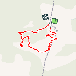
13.5 km | 17.2 km-effort
2h 31min
Yes
Trail Motor Codalet - Prades - Villefranche de Conflent - Evol  - Photo
Motor
crijack

Motor

Easy
(1)
Codalet, Occitania, Pyrénées-Orientales, France
36 km | 48 km-effort
3h 47min
No
Trail Mountain bike Ria-Sirach - cami del pi - Photo
Mountain bike
fine66

Mountain bike

Very easy
(1)
Ria-Sirach, Occitania, Pyrénées-Orientales, France
11.2 km | 18.4 km-effort
1h 52min
Yes
Trail Walking Taurinya - le Canigou depuis le col de Millères - Photo
Walking
Machaon6

Walking

Difficult
(1)
Taurinya, Occitania, Pyrénées-Orientales, France
22 km | 48 km-effort
8h 30min
Yes
Trail Walking Taurinya - b - Photo
Walking
66Gribouille83

Walking

Very difficult
Taurinya, Occitania, Pyrénées-Orientales, France
14.7 km | 23 km-effort
6h 7min
Yes
Trail sport Finestret - 20250109 petite boucle depuis Finestret - Photo
sport
ThonyM

sport

Very easy
Finestret, Occitania, Pyrénées-Orientales, France
10.1 km | 16.5 km-effort
Unknown
Yes
Trail Walking Codalet - le tour de saint Michel de cuxià - Photo
Walking
michelle.ceres@wanadoo.fr

Walking

Medium
Codalet, Occitania, Pyrénées-Orientales, France
8.1 km | 11.1 km-effort
2h 37min
Yes
Trail Walking Codalet - Codalet /Taurinya / St Michel de cuca - Photo
Walking
robertperello

Walking

Medium
Codalet, Occitania, Pyrénées-Orientales, France
14.4 km | 21 km-effort
3h 49min
No
Trail Walking Prades - codalet . coll de Clara . abbaye St Michel de Cuxa . canal bohère - Photo
Walking
GUIDE
stef789

Walking

Medium
Prades, Occitania, Pyrénées-Orientales, France
9.8 km | 14.7 km-effort
4h 21min
Yes


Close
My subscriptions