![](/images/other/stat-length.png)
![Trail Mountain bike Méré - _Sur les chemins de traverse - Photo](https://media.geolcdn.com/t/1900/400/ext.pjpeg?maxdim=2&url=https%3A%2F%2Fstatic1.geolcdn.com%2Fsiteimages%2Fupload%2Ffiles%2F1524743154velo.jpg)
_Sur les chemins de traverse
Parc naturel régional de la Haute Vallée de Chevreuse
Randonnées du Parc naturel régional de la Haute Vallée de Chevreuse GUIDE+
![Length](/images/other/stat-length.png)
![Max alt](https://static1.geolcdn.com/siteimages/upload/files/1508320355ic_sort_altitude_max_24dp.png)
![Uphill gradient](https://static1.geolcdn.com/siteimages/upload/files/1508320355ic_sort_den_pos_24dp.png)
![Km-Effort](/images/other/stat-length.png)
![Min alt](https://static1.geolcdn.com/siteimages/upload/files/1508320355ic_sort_altitude_min_24dp.png)
![Downhill gradient](https://static1.geolcdn.com/siteimages/upload/files/1508320355ic_sort_den_neg_24dp.png)
![Boucle](https://static1.geolcdn.com/siteimages/upload/files/16400158638029165_repeat_loop_refresh_sync_direction_icon.png)
![Mountain bike](https://static1.geolcdn.com/sitytour/trail-icons/202.png)
2h15
Difficulty : Medium
![Scan this QR Code to open this trail in the SityTrail application](https://capi.geolives.com/qq0zvz2zws4bq2lad0pu/sitytour/trails/801102/qr.png?size=200)
FREE GPS app for hiking
About
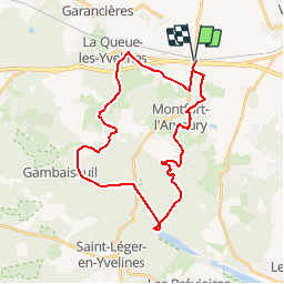
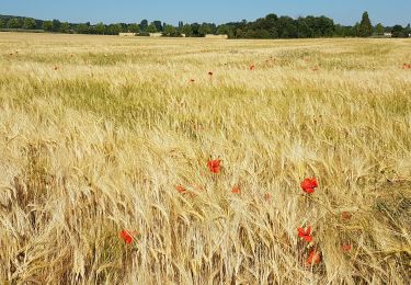
Trail Mountain bike of 30 km to be discovered at Ile-de-France, Yvelines, Méré. This trail is proposed by Parc naturel régional de la Haute Vallée de Chevreuse.
Description
Empruntez les chemins de traverse du pays de Montfort jalonnés
d'anciennes demeures, de maisons d'écrivains et d'artistes... Environné
de paysages bucoliques, vous découvrirez des lieux secrets (ou presque)
qui vous enchanteront.
Positioning
Comments
Trails nearby
![Trail Walking Bazoches-sur-Guyonne - _Les chaumières de Bazoches - Photo](https://media.geolcdn.com/t/375/260/ext.jpg?maxdim=2&url=https%3A%2F%2Fservices.sitytrail.com%2FGeolivesWS%2FDownloadMedia.ashx%3FTrailID%3D784205%26Media%3D50afe0be-7e96-47da-a0b5-41d8dcd474a4.JPG)
![Walking Walking](https://static1.geolcdn.com/sitytour/trail-icons/101.png)
Walking
![](/images/other/stat-length.png)
![](https://static1.geolcdn.com/siteimages/upload/files/16400158638029165_repeat_loop_refresh_sync_direction_icon.png)
![Trail Walking Le Tremblay-sur-Mauldre - rando du 12/03/2015 - Photo](https://media.geolcdn.com/t/375/260/ext.jpg?maxdim=2&url=https%3A%2F%2Fservices.sitytrail.com%2FGeolivesWS%2FDownloadMedia.ashx%3FTrailID%3D394961%26Media%3Dfix__20150312095010.jpg)
![Walking Walking](https://static1.geolcdn.com/sitytour/trail-icons/101.png)
Walking
![](/images/other/stat-length.png)
![](https://static1.geolcdn.com/siteimages/upload/files/16400158638029165_repeat_loop_refresh_sync_direction_icon.png)
![Trail Walking Auteuil - Auteuil Villiers le Mahieu - Photo](https://media.geolcdn.com/t/375/260/ext.jpg?maxdim=2&url=https%3A%2F%2Fstatic1.geolcdn.com%2Fsiteimages%2Fupload%2Ffiles%2F1553511878bg_sport_marche.png)
![Walking Walking](https://static1.geolcdn.com/sitytour/trail-icons/101.png)
Walking
![](/images/other/stat-length.png)
![](https://static1.geolcdn.com/siteimages/upload/files/16400158638029165_repeat_loop_refresh_sync_direction_icon.png)
![Trail Walking Montfort-l'Amaury - Yvelines_[Rando_Journée]_Montfort=>Les Mesnuls=>Autour_de_Montfort - Tronçon 1 - Photo](https://media.geolcdn.com/t/375/260/9a77b4d0-afa4-42cb-beea-4a17fa8cb8c3.jpg&format=jpg&maxdim=2)
![Walking Walking](https://static1.geolcdn.com/sitytour/trail-icons/101.png)
Walking
![](/images/other/stat-length.png)
![](https://static1.geolcdn.com/siteimages/upload/files/16400158638029165_repeat_loop_refresh_sync_direction_icon.png)
![Trail Walking Montfort-l'Amaury - Yvelines_[Rando_Journée]_Montfort=>Les Mesnuls=>Autour_de_Montfort - Tronçon 2 - Photo](https://media.geolcdn.com/t/375/260/3a031c20-1fc4-4232-b97e-93470db48f02.jpg&format=jpg&maxdim=2)
![Walking Walking](https://static1.geolcdn.com/sitytour/trail-icons/101.png)
Walking
![](/images/other/stat-length.png)
![](https://static1.geolcdn.com/siteimages/upload/files/16400158638029165_repeat_loop_refresh_sync_direction_icon.png)
![Trail Walking Montfort-l'Amaury - SityTrail - Montfort - Les Mesnils - Photo](https://media.geolcdn.com/t/375/260/87104e12-16e9-47e9-9422-03ff8e98753c.jpg&format=jpg&maxdim=2)
![Walking Walking](https://static1.geolcdn.com/sitytour/trail-icons/101.png)
Walking
![](/images/other/stat-length.png)
![](https://static1.geolcdn.com/siteimages/upload/files/16400158638029165_repeat_loop_refresh_sync_direction_icon.png)
![Trail Walking Bazoches-sur-Guyonne - Bazoches - Photo](https://media.geolcdn.com/t/375/260/87864db8-2755-4cea-9ed1-b64f1c4148b4.jpg&format=jpg&maxdim=2)
![Walking Walking](https://static1.geolcdn.com/sitytour/trail-icons/101.png)
Walking
![](/images/other/stat-length.png)
![](https://static1.geolcdn.com/siteimages/upload/files/16400158638029165_repeat_loop_refresh_sync_direction_icon.png)
![Trail Plane Neauphle-le-Vieux - Chavenay Etretat - Photo](https://media.geolcdn.com/t/375/260/65d156d0-9e35-4d1c-b0c6-dae3b8d81c13.jpg&format=jpg&maxdim=2)
![Plane Plane](https://static1.geolcdn.com/sitytour/trail-icons/601.png)
Plane
![](/images/other/stat-length.png)
![](https://static1.geolcdn.com/siteimages/upload/files/16400158638029165_repeat_loop_refresh_sync_direction_icon.png)
![Trail Walking Méré - Méré Montfort l'Amaury-St. Léger en Yvelines - Photo](https://media.geolcdn.com/t/375/260/478ea850-a94f-4955-bea2-88d9ef4601c2.jpg&format=jpg&maxdim=2)
![Walking Walking](https://static1.geolcdn.com/sitytour/trail-icons/101.png)
Walking
![](/images/other/stat-length.png)
![](https://static1.geolcdn.com/siteimages/upload/files/16400158638029165_repeat_loop_refresh_sync_direction_icon.png)