


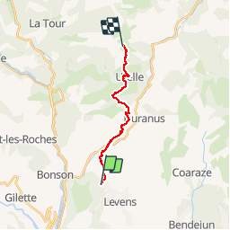

17 km | 30 km-effort


User


FREE GPS app for hiking
 SityTrail
IGN / Geographical institutes
SityTrail World
The world is yours!
Trail Walking of 14.7 km to be discovered at Provence-Alpes-Côte d'Azur, Maritime Alps, Levens. This trail is proposed by albert318.
Hike Mercantour: De Levens au col du Castel Gineste. Attention, plus de magasin à Utelle et pas de point d'eau dans la montagne

Walking

Walking

On foot

On foot

Walking
Walking
Walking

Walking
Walking