Trail Mountain bike Sainte-Geneviève-des-Bois - 2017-07-29 rando sgdb notre dame paris - Photo

2017-07-29 rando sgdb notre dame paris

© OpenStreetMap contributors
Length
Length
93 km
Max alt
Max alt
107 m
Uphill gradient
Uphill gradient
884 m
Km-Effort
Km-Effort  
105 km
Min alt
Min alt
23 m
Downhill gradient
Downhill gradient
887 m
Boucle
Boucle
No
Creation date :
2018-09-15 15:03:28.312
Updated on :
2018-09-15 15:03:28.821

(0 Reviews)

Mountain bike
Mountain bike
6h31
Difficulty : Easy

Scan this QR Code to open this trail in the SityTrail application

FREE GPS app for hiking

Logo SityTrail SityTrail

IGN / Geographical institutes

Download SityTrail from the App Store Download SityTrail from Google Play

Logo SityTrail SityTrail World

The world is yours!

Download SityTrail from the App Store Download SityTrail from Google Play Download SityTrail on Huawei AppGallery

About

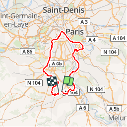
Trail Mountain bike of 93 km to be discovered at Ile-de-France, Essonne, Sainte-Geneviève-des-Bois. This trail is proposed by Lucquiaud.

Description

je dois traverser le bois de St Eutrope,descendre à la Seine; je longe la Seine en passant par les ponts qui ont été refaits (avant le Port aux Cerises); (la passerelle d'Ablon sur la Seine toujours fermée); à Créteil, je passe par la gare pour rejoindre les bords de Marne, arriver au confluent, et suivre la Seine jusqu'à Notre Dame de Paris; je dois descendre jusqu'à la porte de Vanves pour attraper la coulée verte; à Palaiseau, je décide d'aller suivre l'Yvette, de traverser Longjumeau pour aller chercher la vallée de l'Orge jusqu'à Sainte Genviève

Elevation profile

Positioning

Country:
France
Region :
Ile-de-France
Department/Province :
Essonne
Municipality :
Sainte-Geneviève-des-Bois
Location:
Unknown
Start:(UTM)
452125 ; 5387108 (31U) N.

Trails nearby

Trail Walking Ballainvilliers - GRP CV-IDF 2023 - Photo
Walking
clalaur

Walking

Very difficult
(1)
Ballainvilliers, Ile-de-France, Essonne, France
15.5 km | 19.1 km-effort
4h 20min
No
Trail Walking Brétigny-sur-Orge - Boucle Bretigny - Arpajon - Photo
Walking
GUIDE
chessyca

Walking

Difficult
Brétigny-sur-Orge, Ile-de-France, Essonne, France
30 km | 36 km-effort
6h 19min
Yes
Trail On foot Morsang-sur-Orge - Boucle 20 km Morsang sur Orge - Photo
On foot
GUIDE
chessyca

On foot

Easy
Morsang-sur-Orge, Ile-de-France, Essonne, France
20 km | 22 km-effort
5h 6min
Yes
Trail Walking Longpont-sur-Orge - SityTrail - Bassins du Carouge-Longpont sur Orge - Photo
Walking
albg

Walking

Medium
(1)
Longpont-sur-Orge, Ile-de-France, Essonne, France
9.3 km | 10.4 km-effort
2h 22min
Yes
Trail Mountain bike Bondoufle - rando
Mountain bike
marsupio

Mountain bike

Easy
(1)
Bondoufle, Ile-de-France, Essonne, France
56 km | 63 km-effort
8min
Yes
Trail Mountain bike Bondoufle - Senart - Photo
Mountain bike
godmer

Mountain bike

Very difficult
(1)
Bondoufle, Ile-de-France, Essonne, France
46 km | 52 km-effort
3h 30min
Yes
Trail Mountain bike Bondoufle - Sortie club du 29/09/2019 - Photo
Mountain bike
godmer

Mountain bike

Difficult
(1)
Bondoufle, Ile-de-France, Essonne, France
32 km | 36 km-effort
2h 25min
Yes
Trail Walking Fleury-Mérogis - Fleury-Méfrogis - Forêt Régionale de Saint-Eutrope - Photo
Walking
guydu41

Walking

Easy
Fleury-Mérogis, Ile-de-France, Essonne, France
6.3 km | 7 km-effort
1h 35min
Yes
Trail Walking Saint-Michel-sur-Orge - Le long de l'Orge et de la Boëlle - Photo
Walking
c.chehere

Walking

Easy
Saint-Michel-sur-Orge, Ile-de-France, Essonne, France
14.9 km | 17.1 km-effort
3h 38min
Yes


Close
My subscriptions