![](/images/other/stat-length.png)
![Trail Walking Neuvéglise-sur-Truyère - Tour pédestre du Cantal 2017 Lavastrie - Photo](https://media.geolcdn.com/t/1900/400/ext.pjpeg?maxdim=2&url=https%3A%2F%2Fstatic1.geolcdn.com%2Fsiteimages%2Fupload%2Ffiles%2F1553511878bg_sport_marche.png)
Tour pédestre du Cantal 2017 Lavastrie
planets
User
![Length](/images/other/stat-length.png)
![Max alt](https://static1.geolcdn.com/siteimages/upload/files/1508320355ic_sort_altitude_max_24dp.png)
![Uphill gradient](https://static1.geolcdn.com/siteimages/upload/files/1508320355ic_sort_den_pos_24dp.png)
![Km-Effort](/images/other/stat-length.png)
![Min alt](https://static1.geolcdn.com/siteimages/upload/files/1508320355ic_sort_altitude_min_24dp.png)
![Downhill gradient](https://static1.geolcdn.com/siteimages/upload/files/1508320355ic_sort_den_neg_24dp.png)
![Boucle](https://static1.geolcdn.com/siteimages/upload/files/16400158638029165_repeat_loop_refresh_sync_direction_icon.png)
![Walking](https://static1.geolcdn.com/sitytour/trail-icons/101.png)
4h57
Difficulty : Easy
![Scan this QR Code to open this trail in the SityTrail application](https://capi.geolives.com/qq0zvz2zws4bq2lad0pu/sitytour/trails/798473/qr.png?size=200)
FREE GPS app for hiking
About
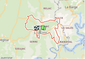
Trail Walking of 17.6 km to be discovered at Auvergne-Rhône-Alpes, Cantal, Neuvéglise-sur-Truyère. This trail is proposed by planets.
Description
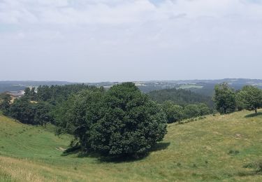
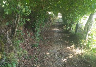
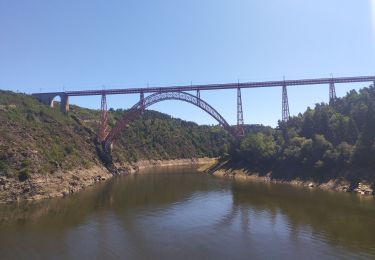
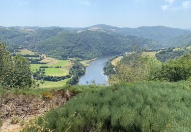
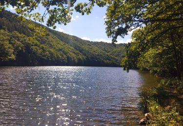
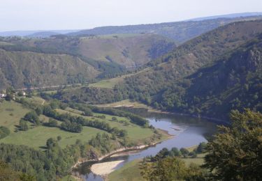
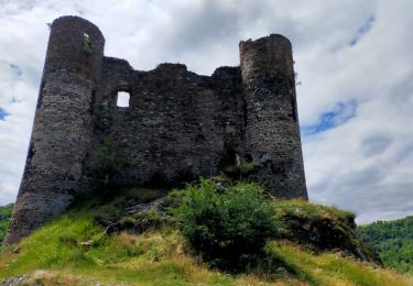
Descente du bourg jusqu'à une belle vue sur le barrage et le lac. Le vieux four de Fauges mérite un petit arrêt. Retour sur le plateau. Petite Chapelle à Fontbonne dédiée à Saint Roch. Architecture remarquable à Tarrieux. Point de vue sur le lac et la Margeride depuis le puy de Montbrun (on voie le viaduc de Garabit). Belle église et jolies maisons au bourg à Lavastrie.
Positioning
Comments
Trails nearby
![Trail Walking Fridefont - Magnac - Photo](https://media.geolcdn.com/t/375/260/bd259a51-4b76-408c-92e2-ca82a9517d42.jpg&format=jpg&maxdim=2)
![Walking Walking](https://static1.geolcdn.com/sitytour/trail-icons/101.png)
Walking
![](/images/other/stat-length.png)
![](https://static1.geolcdn.com/siteimages/upload/files/16400158638029165_repeat_loop_refresh_sync_direction_icon.png)
![Trail Walking Fridefont - Les gorges de Bès - Photo](https://media.geolcdn.com/t/375/260/355a8234-906c-48fe-a1fa-b94a4304f223.jpg&format=jpg&maxdim=2)
![Walking Walking](https://static1.geolcdn.com/sitytour/trail-icons/101.png)
Walking
![](/images/other/stat-length.png)
![](https://static1.geolcdn.com/siteimages/upload/files/16400158638029165_repeat_loop_refresh_sync_direction_icon.png)
![Trail Road bike Fridefont - La vallée de Truyère - Photo](https://media.geolcdn.com/t/375/260/7b822ba6-e872-4da7-b587-53102ee447a8.jpg&format=jpg&maxdim=2)
![Road bike Road bike](https://static1.geolcdn.com/sitytour/trail-icons/201.png)
Road bike
![](/images/other/stat-length.png)
![](https://static1.geolcdn.com/siteimages/upload/files/16400158638029165_repeat_loop_refresh_sync_direction_icon.png)
![Trail Walking Fridefont - Magnan - Photo](https://media.geolcdn.com/t/375/260/3a9b6554-8053-4aed-ad8a-158ccb895998.jpg&format=jpg&maxdim=2)
![Walking Walking](https://static1.geolcdn.com/sitytour/trail-icons/101.png)
Walking
![](/images/other/stat-length.png)
![](https://static1.geolcdn.com/siteimages/upload/files/16400158638029165_repeat_loop_refresh_sync_direction_icon.png)
![Trail Running Fridefont - La Mourache - Photo](https://media.geolcdn.com/t/375/260/a1a0bff6-c2ab-4782-9c75-2642aa8c3415.jpg&format=jpg&maxdim=2)
![Running Running](https://static1.geolcdn.com/sitytour/trail-icons/103.png)
Running
![](/images/other/stat-length.png)
![](https://static1.geolcdn.com/siteimages/upload/files/16400158638029165_repeat_loop_refresh_sync_direction_icon.png)
![Trail Walking Alleuze - Château d'Alleuze - Barrage Grandval - Photo](https://media.geolcdn.com/t/375/260/ext.jpg?maxdim=2&url=https%3A%2F%2Fservices.sitytrail.com%2FGeolivesWS%2FDownloadMedia.ashx%3FTrailID%3D103757%26Media%3D6498_6.jpg)
![Walking Walking](https://static1.geolcdn.com/sitytour/trail-icons/101.png)
Walking
![](/images/other/stat-length.png)
![](https://static1.geolcdn.com/siteimages/upload/files/16400158638029165_repeat_loop_refresh_sync_direction_icon.png)
![Trail Walking Neuvéglise-sur-Truyère - près du camping Le Belvédère - Photo](https://media.geolcdn.com/t/375/260/d5d9a9f4-c90f-48f5-8e43-c66d87dc728c.jpg&format=jpg&maxdim=2)
![Walking Walking](https://static1.geolcdn.com/sitytour/trail-icons/101.png)
Walking
![](/images/other/stat-length.png)
![](https://static1.geolcdn.com/siteimages/upload/files/16400158638029165_repeat_loop_refresh_sync_direction_icon.png)
![Trail Walking Alleuze - Alleuze - Photo](https://media.geolcdn.com/t/375/260/3c7f5b1f-6c46-455a-8c8b-16b802134439.jpg&format=jpg&maxdim=2)
![Walking Walking](https://static1.geolcdn.com/sitytour/trail-icons/101.png)
Walking
![](/images/other/stat-length.png)
![](https://static1.geolcdn.com/siteimages/upload/files/16400158638029165_repeat_loop_refresh_sync_direction_icon.png)
![Trail Electric bike Neuvéglise-sur-Truyère - boucle Montbrun confinement - Photo](https://media.geolcdn.com/t/375/260/6e40c1c8-454c-4f0e-80c8-06c04188a558.jpg&format=jpg&maxdim=2)
![Electric bike Electric bike](https://static1.geolcdn.com/sitytour/trail-icons/205.png)
Electric bike
![](/images/other/stat-length.png)
![](https://static1.geolcdn.com/siteimages/upload/files/16400158638029165_repeat_loop_refresh_sync_direction_icon.png)