![](/images/other/stat-length.png)
![Trail Walking Teyssières - Cougoir( départ Teyssières vieux village) - Photo](https://media.geolcdn.com/t/1900/400/ext.pjpeg?maxdim=2&url=https%3A%2F%2Fstatic1.geolcdn.com%2Fsiteimages%2Fupload%2Ffiles%2F1553511878bg_sport_marche.png)
Cougoir( départ Teyssières vieux village)
YVESBRULARD
User
![Length](/images/other/stat-length.png)
Length
12.6 km
![Max alt](https://static1.geolcdn.com/siteimages/upload/files/1508320355ic_sort_altitude_max_24dp.png)
Max alt
1205 m
![Uphill gradient](https://static1.geolcdn.com/siteimages/upload/files/1508320355ic_sort_den_pos_24dp.png)
Uphill gradient
733 m
![Km-Effort](/images/other/stat-length.png)
Km-Effort
22 km
![Min alt](https://static1.geolcdn.com/siteimages/upload/files/1508320355ic_sort_altitude_min_24dp.png)
Min alt
644 m
![Downhill gradient](https://static1.geolcdn.com/siteimages/upload/files/1508320355ic_sort_den_neg_24dp.png)
Downhill gradient
714 m
![Boucle](https://static1.geolcdn.com/siteimages/upload/files/16400158638029165_repeat_loop_refresh_sync_direction_icon.png)
Boucle
No
Creation date :
2017-07-29 00:00:00.0
Updated on :
2017-07-29 00:00:00.0
![Walking](https://static1.geolcdn.com/sitytour/trail-icons/101.png)
5h00
Difficulty : Difficult
![Scan this QR Code to open this trail in the SityTrail application](https://capi.geolives.com/qq0zvz2zws4bq2lad0pu/sitytour/trails/798285/qr.png?size=200)
FREE GPS app for hiking
About
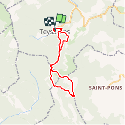
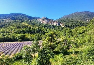
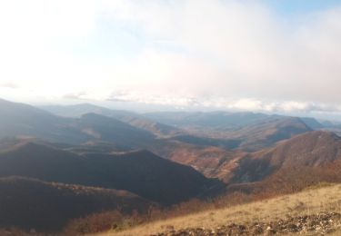
Trail Walking of 12.6 km to be discovered at Auvergne-Rhône-Alpes, Drôme, Teyssières. This trail is proposed by YVESBRULARD.
Description
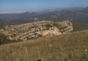
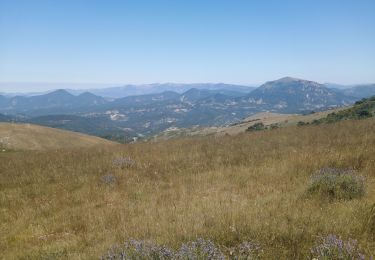
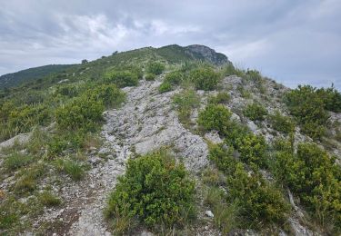
Près de la montagne Angèle, Cougoir est un promontoire rocheux bien détaché, offrant une vue remarquable sur la Drôme provençale et le Nyonsais, ses montagnes, vallons et villages.
Positioning
Country:
France
Region :
Auvergne-Rhône-Alpes
Department/Province :
Drôme
Municipality :
Teyssières
Location:
Unknown
Start:(Dec)
Start:(UTM)
669625 ; 4924131 (31T) N.
Comments
Trails nearby
![Trail Walking Rousset-les-Vignes - Rousset- La Lance - Photo](https://media.geolcdn.com/t/375/260/84d3931f-2eee-4f55-959d-db8a6d419ca0.jpg&format=jpg&maxdim=2)
![Walking Walking](https://static1.geolcdn.com/sitytour/trail-icons/101.png)
Rousset- La Lance
Walking
Difficult
(1)
Rousset-les-Vignes,
Auvergne-Rhône-Alpes,
Drôme,
France
![](/images/other/stat-length.png)
14 km | 26 km-effort
2h 55min
![](https://static1.geolcdn.com/siteimages/upload/files/16400158638029165_repeat_loop_refresh_sync_direction_icon.png)
Yes
![Trail Walking Teyssières - 26 cougoir zel - Photo](https://media.geolcdn.com/t/375/260/73f2a032-a019-4e88-aecb-d5d32d3ee0aa.jpg&format=jpg&maxdim=2)
![Walking Walking](https://static1.geolcdn.com/sitytour/trail-icons/101.png)
26 cougoir zel
Walking
Medium
Teyssières,
Auvergne-Rhône-Alpes,
Drôme,
France
![](/images/other/stat-length.png)
13 km | 23 km-effort
6h 24min
![](https://static1.geolcdn.com/siteimages/upload/files/16400158638029165_repeat_loop_refresh_sync_direction_icon.png)
No
![Trail Walking Venterol - le cougoir - Photo](https://media.geolcdn.com/t/375/260/37fd75d5-0091-4964-9bad-4ec775b5e571.jpg&format=jpg&maxdim=2)
![Walking Walking](https://static1.geolcdn.com/sitytour/trail-icons/101.png)
le cougoir
Walking
Medium
Venterol,
Auvergne-Rhône-Alpes,
Drôme,
France
![](/images/other/stat-length.png)
11.4 km | 19.7 km-effort
3h 46min
![](https://static1.geolcdn.com/siteimages/upload/files/16400158638029165_repeat_loop_refresh_sync_direction_icon.png)
No
![Trail Walking Teyssières - Randonnée au départ de Teyssières (Le Cougoir, La Lance) - Photo](https://media.geolcdn.com/t/375/260/94a27539-2910-4367-af66-73c1555d2126.jpg&format=jpg&maxdim=2)
![Walking Walking](https://static1.geolcdn.com/sitytour/trail-icons/101.png)
Randonnée au départ de Teyssières (Le Cougoir, La Lance)
Walking
Very difficult
Teyssières,
Auvergne-Rhône-Alpes,
Drôme,
France
![](/images/other/stat-length.png)
22 km | 40 km-effort
9h 2min
![](https://static1.geolcdn.com/siteimages/upload/files/16400158638029165_repeat_loop_refresh_sync_direction_icon.png)
Yes
![Trail Walking Teyssières - 2022-09-27_10h31m20_Teyssieres Cougoir 12km - Photo](https://media.geolcdn.com/t/375/260/c1b90102-3f17-42c6-9eaa-274a207a9df3.jpg&format=jpg&maxdim=2)
![Walking Walking](https://static1.geolcdn.com/sitytour/trail-icons/101.png)
2022-09-27_10h31m20_Teyssieres Cougoir 12km
Walking
Very difficult
Teyssières,
Auvergne-Rhône-Alpes,
Drôme,
France
![](/images/other/stat-length.png)
11.9 km | 21 km-effort
4h 50min
![](https://static1.geolcdn.com/siteimages/upload/files/16400158638029165_repeat_loop_refresh_sync_direction_icon.png)
Yes
![Trail Walking Valouse - mielandre - Photo](https://media.geolcdn.com/t/375/260/f5718be0-7b70-47ac-8b04-32aa7a492791.jpg&format=jpg&maxdim=2)
![Walking Walking](https://static1.geolcdn.com/sitytour/trail-icons/101.png)
mielandre
Walking
Very difficult
Valouse,
Auvergne-Rhône-Alpes,
Drôme,
France
![](/images/other/stat-length.png)
11.3 km | 23 km-effort
6h 34min
![](https://static1.geolcdn.com/siteimages/upload/files/16400158638029165_repeat_loop_refresh_sync_direction_icon.png)
Yes
![Trail Walking Valouse - 2021_11_14 - Photo](https://media.geolcdn.com/t/375/260/82af798d-3a29-4075-90aa-5e2c8e883cf5.jpg&format=jpg&maxdim=2)
![Walking Walking](https://static1.geolcdn.com/sitytour/trail-icons/101.png)
2021_11_14
Walking
Easy
Valouse,
Auvergne-Rhône-Alpes,
Drôme,
France
![](/images/other/stat-length.png)
10.5 km | 22 km-effort
3h 33min
![](https://static1.geolcdn.com/siteimages/upload/files/16400158638029165_repeat_loop_refresh_sync_direction_icon.png)
Yes
![Trail Walking Valouse - 2021_11_14 Miélandre - Photo](https://media.geolcdn.com/t/375/260/32d9fd14-76e6-4731-8210-b2cb388c409f.jpg&format=jpg&maxdim=2)
![Walking Walking](https://static1.geolcdn.com/sitytour/trail-icons/101.png)
2021_11_14 Miélandre
Walking
Very difficult
Valouse,
Auvergne-Rhône-Alpes,
Drôme,
France
![](/images/other/stat-length.png)
10.5 km | 22 km-effort
3h 50min
![](https://static1.geolcdn.com/siteimages/upload/files/16400158638029165_repeat_loop_refresh_sync_direction_icon.png)
Yes
![Trail Walking Venterol - Col de la Sausse par la Combe de Sauve - Photo](https://media.geolcdn.com/t/375/260/ext.jpg?maxdim=2&url=https%3A%2F%2Fstatic1.geolcdn.com%2Fsiteimages%2Fupload%2Ffiles%2F1553511878bg_sport_marche.png)
![Walking Walking](https://static1.geolcdn.com/sitytour/trail-icons/101.png)
Col de la Sausse par la Combe de Sauve
Walking
Very easy
(1)
Venterol,
Auvergne-Rhône-Alpes,
Drôme,
France
![](/images/other/stat-length.png)
5.3 km | 8.7 km-effort
1h 46min
![](https://static1.geolcdn.com/siteimages/upload/files/16400158638029165_repeat_loop_refresh_sync_direction_icon.png)
Yes