![](/images/other/stat-length.png)
![Trail Walking Balazuc - Rando BALAZUC - le vieil Audon - Photo](https://media.geolcdn.com/t/1900/400/ext.pjpeg?maxdim=2&url=https%3A%2F%2Fstatic1.geolcdn.com%2Fsiteimages%2Fupload%2Ffiles%2F1553511878bg_sport_marche.png)
Rando BALAZUC - le vieil Audon
namoureux
User
![Length](/images/other/stat-length.png)
![Max alt](https://static1.geolcdn.com/siteimages/upload/files/1508320355ic_sort_altitude_max_24dp.png)
![Uphill gradient](https://static1.geolcdn.com/siteimages/upload/files/1508320355ic_sort_den_pos_24dp.png)
![Km-Effort](/images/other/stat-length.png)
![Min alt](https://static1.geolcdn.com/siteimages/upload/files/1508320355ic_sort_altitude_min_24dp.png)
![Downhill gradient](https://static1.geolcdn.com/siteimages/upload/files/1508320355ic_sort_den_neg_24dp.png)
![Boucle](https://static1.geolcdn.com/siteimages/upload/files/16400158638029165_repeat_loop_refresh_sync_direction_icon.png)
![Walking](https://static1.geolcdn.com/sitytour/trail-icons/101.png)
2h00
Difficulty : Difficult
![Scan this QR Code to open this trail in the SityTrail application](https://capi.geolives.com/qq0zvz2zws4bq2lad0pu/sitytour/trails/796249/qr.png?size=200)
FREE GPS app for hiking
About
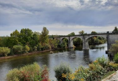
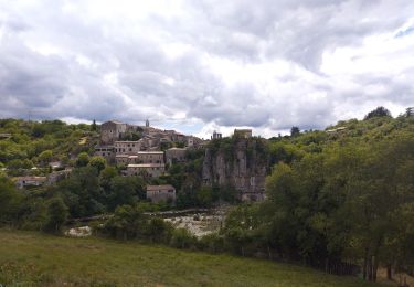
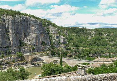
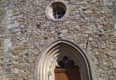
Trail Walking of 4.8 km to be discovered at Auvergne-Rhône-Alpes, Ardèche, Balazuc. This trail is proposed by namoureux.
Description
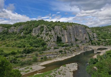
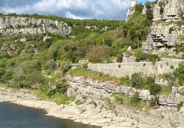
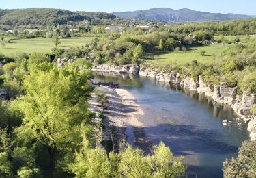
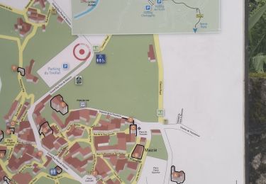
Rando sportive au départ du charmant village de Balazuc,
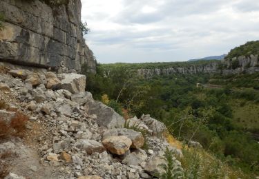
on descend via un chemin de terre jusqu'au bord de l'ardèche, ensuite on traverse via le pont et on se dirige jusqu'au village du Vieil Audon, et si vous aimez les glaces aux saveurs originales et délicieuses, un arrêt s'impose ! Ensuite on remonte le sentier jusqu'au sommet pour redescendre une petite partie de route avant de prendre un petit chemin sur la droite qui vous ménera jusqu'à un ancien torrent ! Là vous avez 2 possibilités, soit remonter sur la route et redescendre via celle-ci, ou alors descendre l'ancien torrent, mais attention car cette descente est sportive et un peu dangereuse car on arrive au dessus d'un apic de 10-15 mètres qu'il faut descendre par palier, tout d'abord via un petit chemin sur la droite et ensuite en faisant un peu d'escalade via les escaliers natuellement créés ! Terminer ensuite la descente jusqu'à la clôture amovible et retour vers Balazuc via le même chemin qu'à l'aller. Dans Balazuc, différentes petites ruelles sont à découvrir. Bon amusement et soyez prudent. ;-)
Positioning
Comments
Trails nearby
![Trail Walking Vogüé - Vogue Gare Lanas 7km5 - Photo](https://media.geolcdn.com/t/375/260/9aa975b1-7a6b-4ed1-96ac-4f4c9e1e47b3.jpg&format=jpg&maxdim=2)
![Walking Walking](https://static1.geolcdn.com/sitytour/trail-icons/101.png)
Walking
![](/images/other/stat-length.png)
![](https://static1.geolcdn.com/siteimages/upload/files/16400158638029165_repeat_loop_refresh_sync_direction_icon.png)
![Trail Walking Chauzon - camping le coin charmant Chauzon à Balazuc - Photo](https://media.geolcdn.com/t/375/260/9e3472da-95e6-4ca9-9834-4874ef8e1852.jpg&format=jpg&maxdim=2)
![Walking Walking](https://static1.geolcdn.com/sitytour/trail-icons/101.png)
Walking
![](/images/other/stat-length.png)
![](https://static1.geolcdn.com/siteimages/upload/files/16400158638029165_repeat_loop_refresh_sync_direction_icon.png)
![Trail Walking Pradons - Pradons Gens Abeille 18km - Photo](https://media.geolcdn.com/t/375/260/c0a42803-b9d9-46b0-bff8-8a8a9dfe0f63.jpg&format=jpg&maxdim=2)
![Walking Walking](https://static1.geolcdn.com/sitytour/trail-icons/101.png)
Walking
![](/images/other/stat-length.png)
![](https://static1.geolcdn.com/siteimages/upload/files/16400158638029165_repeat_loop_refresh_sync_direction_icon.png)
![Trail Walking Balazuc - 2024-07-01_17h54m21_Balazuc Cirque de Gens 19km - Photo](https://media.geolcdn.com/t/375/260/6d01c6fd-5949-41a2-b340-daa374c534bc.jpg&format=jpg&maxdim=2)
![Walking Walking](https://static1.geolcdn.com/sitytour/trail-icons/101.png)
Walking
![](/images/other/stat-length.png)
![](https://static1.geolcdn.com/siteimages/upload/files/16400158638029165_repeat_loop_refresh_sync_direction_icon.png)
![Trail Walking Balazuc - Balazuc Servieres Viel-Audon 9km. - Photo](https://media.geolcdn.com/t/375/260/c62c36d0-f3c1-47de-a635-486a1871b8d7.jpg&format=jpg&maxdim=2)
![Walking Walking](https://static1.geolcdn.com/sitytour/trail-icons/101.png)
Walking
![](/images/other/stat-length.png)
![](https://static1.geolcdn.com/siteimages/upload/files/16400158638029165_repeat_loop_refresh_sync_direction_icon.png)
![Trail sport Balazuc - Balazuc la tour de Jeanne le Viel Audon - Photo](https://media.geolcdn.com/t/375/260/d8c1c8fe-95e6-4adc-b1ae-0d66c200e42e.jpg&format=jpg&maxdim=2)
sport
![](/images/other/stat-length.png)
![](https://static1.geolcdn.com/siteimages/upload/files/16400158638029165_repeat_loop_refresh_sync_direction_icon.png)
![Trail Walking Pradons - 07_pradons_9km260m - Photo](https://media.geolcdn.com/t/375/260/ab387dcb-02e5-4a9b-b847-a6218926558f.jpg&format=jpg&maxdim=2)
![Walking Walking](https://static1.geolcdn.com/sitytour/trail-icons/101.png)
Walking
![](/images/other/stat-length.png)
![](https://static1.geolcdn.com/siteimages/upload/files/16400158638029165_repeat_loop_refresh_sync_direction_icon.png)
![Trail Walking Balazuc - 07_balazuc_5km210m - Photo](https://media.geolcdn.com/t/375/260/e481b746-68c2-4909-8202-14f51609cdb9.jpg&format=jpg&maxdim=2)
![Walking Walking](https://static1.geolcdn.com/sitytour/trail-icons/101.png)
Walking
![](/images/other/stat-length.png)
![](https://static1.geolcdn.com/siteimages/upload/files/16400158638029165_repeat_loop_refresh_sync_direction_icon.png)
![Trail Road bike Vogüé - 07 j3 vogue - Photo](https://media.geolcdn.com/t/375/260/ac9eef10-04ef-4ebf-b837-e792d84c769a.jpg&format=jpg&maxdim=2)
![Road bike Road bike](https://static1.geolcdn.com/sitytour/trail-icons/201.png)
Road bike
![](/images/other/stat-length.png)
![](https://static1.geolcdn.com/siteimages/upload/files/16400158638029165_repeat_loop_refresh_sync_direction_icon.png)