![](/images/other/stat-length.png)
![Trail Mountain bike Moustiers-Sainte-Marie - Plateau de Valensole - Photo](https://media.geolcdn.com/t/1900/400/ext.pjpeg?maxdim=2&url=https%3A%2F%2Fstatic1.geolcdn.com%2Fsiteimages%2Fupload%2Ffiles%2F1524743154velo.jpg)
Plateau de Valensole
doume82
User
![Length](/images/other/stat-length.png)
![Max alt](https://static1.geolcdn.com/siteimages/upload/files/1508320355ic_sort_altitude_max_24dp.png)
![Uphill gradient](https://static1.geolcdn.com/siteimages/upload/files/1508320355ic_sort_den_pos_24dp.png)
![Km-Effort](/images/other/stat-length.png)
![Min alt](https://static1.geolcdn.com/siteimages/upload/files/1508320355ic_sort_altitude_min_24dp.png)
![Downhill gradient](https://static1.geolcdn.com/siteimages/upload/files/1508320355ic_sort_den_neg_24dp.png)
![Boucle](https://static1.geolcdn.com/siteimages/upload/files/16400158638029165_repeat_loop_refresh_sync_direction_icon.png)
![Mountain bike](https://static1.geolcdn.com/sitytour/trail-icons/202.png)
1h51
Difficulty : Easy
![Scan this QR Code to open this trail in the SityTrail application](https://capi.geolives.com/qq0zvz2zws4bq2lad0pu/sitytour/trails/791961/qr.png?size=200)
FREE GPS app for hiking
About
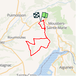
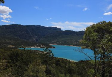
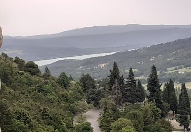
Trail Mountain bike of 24 km to be discovered at Provence-Alpes-Côte d'Azur, Alpes-de-Haute-Provence, Moustiers-Sainte-Marie. This trail is proposed by doume82.
Description
Les champs de lavandes en famille. Attention chemin étroit et sinueux dans la foret proche du départ/fin. Pour les enfants en bas âges mieux vaut partir de la route de Sainte Croix qui monte de Moustiers Ste Marie pour faire vraiment que le plateaux.
Positioning
Comments
Trails nearby
![Trail Walking Moustiers-Sainte-Marie - Tour des Gorges du Verdon - Photo](https://media.geolcdn.com/t/375/260/ext.jpg?maxdim=2&url=https%3A%2F%2Fstatic1.geolcdn.com%2Fsiteimages%2Fupload%2Ffiles%2F1553511878bg_sport_marche.png)
![Walking Walking](https://static1.geolcdn.com/sitytour/trail-icons/101.png)
Walking
![](/images/other/stat-length.png)
![](https://static1.geolcdn.com/siteimages/upload/files/16400158638029165_repeat_loop_refresh_sync_direction_icon.png)
![Trail Walking Moustiers-Sainte-Marie - Moustier Ravin Notre Dame crête de l’Ourbes 14,5 km - Photo](https://media.geolcdn.com/t/375/260/a74da90b-306e-4ee3-bd53-9babe310e6e2.jpg&format=jpg&maxdim=2)
![Walking Walking](https://static1.geolcdn.com/sitytour/trail-icons/101.png)
Walking
![](/images/other/stat-length.png)
![](https://static1.geolcdn.com/siteimages/upload/files/16400158638029165_repeat_loop_refresh_sync_direction_icon.png)
![Trail Walking Moustiers-Sainte-Marie - 2023-02-14 Les grottes de Saint Maurin - Photo](https://media.geolcdn.com/t/375/260/ff240215-b004-40c4-b632-ab00d837cb62.jpg&format=jpg&maxdim=2)
![Walking Walking](https://static1.geolcdn.com/sitytour/trail-icons/101.png)
Walking
![](/images/other/stat-length.png)
![](https://static1.geolcdn.com/siteimages/upload/files/16400158638029165_repeat_loop_refresh_sync_direction_icon.png)
![Trail Walking Moustiers-Sainte-Marie - Moustier saine Marie 11,4 km - Photo](https://media.geolcdn.com/t/375/260/325a0dcc-1ff8-4d2c-a406-91140305788f.jpeg&format=jpg&maxdim=2)
![Walking Walking](https://static1.geolcdn.com/sitytour/trail-icons/101.png)
Walking
![](/images/other/stat-length.png)
![](https://static1.geolcdn.com/siteimages/upload/files/16400158638029165_repeat_loop_refresh_sync_direction_icon.png)
![Trail Walking Moustiers-Sainte-Marie - Moutiers Sainte Marie - Voie Romaine vers Vénascle - Photo](https://media.geolcdn.com/t/375/260/f43e62cf-b80e-49c9-83f1-1f2cdcff5d1b.jpg&format=jpg&maxdim=2)
![Walking Walking](https://static1.geolcdn.com/sitytour/trail-icons/101.png)
Walking
![](/images/other/stat-length.png)
![](https://static1.geolcdn.com/siteimages/upload/files/16400158638029165_repeat_loop_refresh_sync_direction_icon.png)
![Trail Walking Moustiers-Sainte-Marie - Autour de Moustiers st Marie - Photo](https://media.geolcdn.com/t/375/260/ext.jpg?maxdim=2&url=https%3A%2F%2Fservices.sitytrail.com%2FGeolivesWS%2FDownloadMedia.ashx%3FTrailID%3D820131%26Media%3D24900497-3777-4a34-815d-aa485e7dbccc.JPG)
![Walking Walking](https://static1.geolcdn.com/sitytour/trail-icons/101.png)
Walking
![](/images/other/stat-length.png)
![](https://static1.geolcdn.com/siteimages/upload/files/16400158638029165_repeat_loop_refresh_sync_direction_icon.png)
![Trail Walking Moustiers-Sainte-Marie - moustiers ste Marie - Photo](https://media.geolcdn.com/t/375/260/91116718-bfd8-4bd6-8abb-af72a3de0c85.jpg&format=jpg&maxdim=2)
![Walking Walking](https://static1.geolcdn.com/sitytour/trail-icons/101.png)
Walking
![](/images/other/stat-length.png)
![](https://static1.geolcdn.com/siteimages/upload/files/16400158638029165_repeat_loop_refresh_sync_direction_icon.png)
![Trail Walking Puimoisson - 2024-03-12 Puimoisson Aventure - Photo](https://media.geolcdn.com/t/375/260/f144eb6a-0f73-4c6d-9440-c27eff387270.jpg&format=jpg&maxdim=2)
![Walking Walking](https://static1.geolcdn.com/sitytour/trail-icons/101.png)
Walking
![](/images/other/stat-length.png)
![](https://static1.geolcdn.com/siteimages/upload/files/16400158638029165_repeat_loop_refresh_sync_direction_icon.png)
![Trail Walking Moustiers-Sainte-Marie - moustier mont deniers 18k 100m - Photo](https://media.geolcdn.com/t/375/260/8ddff121-5caf-44e2-ae18-5659b34b6078.jpg&format=jpg&maxdim=2)
![Walking Walking](https://static1.geolcdn.com/sitytour/trail-icons/101.png)
Walking
![](/images/other/stat-length.png)
![](https://static1.geolcdn.com/siteimages/upload/files/16400158638029165_repeat_loop_refresh_sync_direction_icon.png)