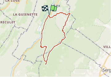
![](/images/other/stat-length.png)
![Trail Walking Lélex - le Crêt de la neige ... le Reculet - Photo](https://media.geolcdn.com/t/1900/400/ext.pjpeg?maxdim=2&url=https%3A%2F%2Fservices.sitytrail.com%2FGeolivesWS%2FDownloadMedia.ashx%3FTrailID%3D791812%26Media%3Dfix__20170715095839.jpg)
le Crêt de la neige ... le Reculet
margotte
User
![Length](/images/other/stat-length.png)
![Max alt](https://static1.geolcdn.com/siteimages/upload/files/1508320355ic_sort_altitude_max_24dp.png)
![Uphill gradient](https://static1.geolcdn.com/siteimages/upload/files/1508320355ic_sort_den_pos_24dp.png)
![Km-Effort](/images/other/stat-length.png)
![Min alt](https://static1.geolcdn.com/siteimages/upload/files/1508320355ic_sort_altitude_min_24dp.png)
![Downhill gradient](https://static1.geolcdn.com/siteimages/upload/files/1508320355ic_sort_den_neg_24dp.png)
![Boucle](https://static1.geolcdn.com/siteimages/upload/files/16400158638029165_repeat_loop_refresh_sync_direction_icon.png)
![Walking](https://static1.geolcdn.com/sitytour/trail-icons/101.png)
5h23
Difficulty : Medium
![Scan this QR Code to open this trail in the SityTrail application](https://capi.geolives.com/qq0zvz2zws4bq2lad0pu/sitytour/trails/791812/qr.png?size=200)
FREE GPS app for hiking
About
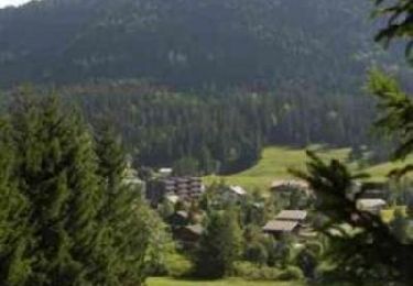
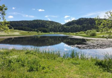
Trail Walking of 14.5 km to be discovered at Auvergne-Rhône-Alpes, Ain, Lélex. This trail is proposed by margotte.
Description
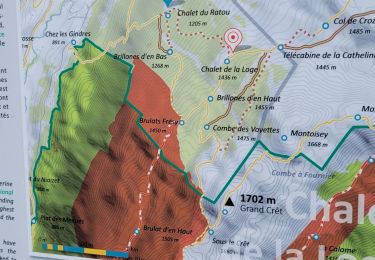
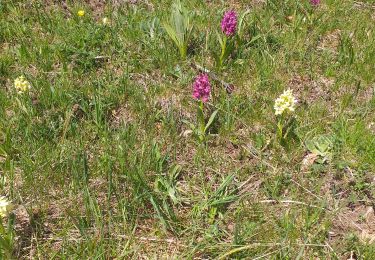
départ au parking côté 891m. Montée raide au départ surtout en suivant le parcours de descente Vtt!! Refuge du ratou et de la loge ouvert mais trop prés du départ pour se désaltérer ou casser la croûte.Balisage important(GR) sur la crête(bien encas de brouillard),. Le sommet du Crêt de la neige est décevant(pour le plus haut sommet du Massif du Jura) juste un rocher sans beaucoup de vue avec des morceaux de croix sur le sommet!!!La vue est plus ouverte en se dirigeant vers le Reculet où là tous les randonneurs se sont donnés RDV au pied d'une mini"tour eiffel" pour casser la croute. En contre bas, sur le chemin du retour, un petit abris permet de sortir son pique nique plus au calme.Le début de la descente est parsemée de fleurs dans un pâturage d'altitude(grande gentiane, digitale jaune... mais par contre tout le reste de la descente (par le sentier des 32 contours)est dans une pente assez raide où les racines des arbres ne permettent pas de relâcher sa vigilance. Arriver au parking du "bas" plus de sentier pour rejoindre la voiture donc on est sur la route en plein soleil(ce jour là)sur 2.7km !!! parcours à faire dans l'autre sens si l'on veut profiter des refuges et faire la route en descente (mieux:faire une dépose de voiture pour éviter la route).
Positioning
Comments
Trails nearby
![Trail Snowshoes Les Moussières - Les poussières raquettes - Photo](https://media.geolcdn.com/t/375/260/5eb23bb8-0279-4d52-b26a-aa4320cff6f9.jpg&format=jpg&maxdim=2)
![Snowshoes Snowshoes](https://static1.geolcdn.com/sitytour/trail-icons/504.png)
Snowshoes
![](/images/other/stat-length.png)
![](https://static1.geolcdn.com/siteimages/upload/files/16400158638029165_repeat_loop_refresh_sync_direction_icon.png)
![Trail Snowshoes Crozet - Crêt de la Neige - Photo](https://media.geolcdn.com/t/375/260/ext.jpg?maxdim=2&url=https%3A%2F%2Fservices.sitytrail.com%2FGeolivesWS%2FDownloadMedia.ashx%3FTrailID%3D189783%26Media%3D9b0b62a1-111a-4594-a9f6-f627c1ac0745.JPG)
![Snowshoes Snowshoes](https://static1.geolcdn.com/sitytour/trail-icons/504.png)
Snowshoes
![](/images/other/stat-length.png)
![](https://static1.geolcdn.com/siteimages/upload/files/16400158638029165_repeat_loop_refresh_sync_direction_icon.png)
![Trail Mountain bike Lélex - Espace VTT FFC Entre Jura et Léman - Circuit n°01 - Les Hautes Combes - Photo](https://media.geolcdn.com/t/375/260/ext.jpg?maxdim=2&url=https%3A%2F%2Fservices.sitytrail.com%2FGeolivesWS%2FDownloadMedia.ashx%3FTrailID%3D102578%26Media%3D3474_1.jpg)
![Mountain bike Mountain bike](https://static1.geolcdn.com/sitytour/trail-icons/202.png)
Mountain bike
![](/images/other/stat-length.png)
![](https://static1.geolcdn.com/siteimages/upload/files/16400158638029165_repeat_loop_refresh_sync_direction_icon.png)
![Trail Walking Crozet - lelex le reculet - Photo](https://media.geolcdn.com/t/375/260/6a7e1719-0f0c-4454-9c96-9405c84666da.jpg&format=jpg&maxdim=2)
![Walking Walking](https://static1.geolcdn.com/sitytour/trail-icons/101.png)
Walking
![](/images/other/stat-length.png)
![](https://static1.geolcdn.com/siteimages/upload/files/16400158638029165_repeat_loop_refresh_sync_direction_icon.png)
![Trail Walking Bellecombe - crêt chalam borne au lion - Photo](https://media.geolcdn.com/t/375/260/3efab7bb-7f7c-430f-937a-9422e220d70a.jpg&format=jpg&maxdim=2)
![Walking Walking](https://static1.geolcdn.com/sitytour/trail-icons/101.png)
Walking
![](/images/other/stat-length.png)
![](https://static1.geolcdn.com/siteimages/upload/files/16400158638029165_repeat_loop_refresh_sync_direction_icon.png)
![Trail Snowshoes Bellecombe - les trois cheminees - Photo](https://media.geolcdn.com/t/375/260/001ddb4c-63f2-4a42-9d23-1880fe969866.jpg&format=jpg&maxdim=2)
![Snowshoes Snowshoes](https://static1.geolcdn.com/sitytour/trail-icons/504.png)
Snowshoes
![](/images/other/stat-length.png)
![](https://static1.geolcdn.com/siteimages/upload/files/16400158638029165_repeat_loop_refresh_sync_direction_icon.png)
![Trail Walking Bellecombe - Les Moussières - Photo](https://media.geolcdn.com/t/375/260/56e9e28b-7e70-40dc-bf63-79a8af5f233a.jpg&format=jpg&maxdim=2)
![Walking Walking](https://static1.geolcdn.com/sitytour/trail-icons/101.png)
Walking
![](/images/other/stat-length.png)
![](https://static1.geolcdn.com/siteimages/upload/files/16400158638029165_repeat_loop_refresh_sync_direction_icon.png)
![Trail Walking Lélex - Lelex Montoisey (IBP 86) 8 mai 2021 CAF - Photo](https://media.geolcdn.com/t/375/260/d17bb35a-85ab-4719-946b-858da2108a6d.jpg&format=jpg&maxdim=2)
![Walking Walking](https://static1.geolcdn.com/sitytour/trail-icons/101.png)
Walking
![](/images/other/stat-length.png)
![](https://static1.geolcdn.com/siteimages/upload/files/16400158638029165_repeat_loop_refresh_sync_direction_icon.png)
![Trail Walking Les Moussières - Sous La Joux - Photo](https://media.geolcdn.com/t/375/260/3c9cb0b3-1bb8-42a9-a65b-32486571d72e.jpg&format=jpg&maxdim=2)
![Walking Walking](https://static1.geolcdn.com/sitytour/trail-icons/101.png)
Walking
![](/images/other/stat-length.png)
![](https://static1.geolcdn.com/siteimages/upload/files/16400158638029165_repeat_loop_refresh_sync_direction_icon.png)