![](/images/other/stat-length.png)
Tancarville: Les cigognes, les cygnes et la vie sauvage du marais
MarcherEnsemble
User
![Length](/images/other/stat-length.png)
Length
8.1 km
![Max alt](https://static1.geolcdn.com/siteimages/upload/files/1508320355ic_sort_altitude_max_24dp.png)
Max alt
8 m
![Uphill gradient](https://static1.geolcdn.com/siteimages/upload/files/1508320355ic_sort_den_pos_24dp.png)
Uphill gradient
26 m
![Km-Effort](/images/other/stat-length.png)
Km-Effort
8.5 km
![Min alt](https://static1.geolcdn.com/siteimages/upload/files/1508320355ic_sort_altitude_min_24dp.png)
Min alt
0 m
![Downhill gradient](https://static1.geolcdn.com/siteimages/upload/files/1508320355ic_sort_den_neg_24dp.png)
Downhill gradient
28 m
![Boucle](https://static1.geolcdn.com/siteimages/upload/files/16400158638029165_repeat_loop_refresh_sync_direction_icon.png)
Boucle
No
Creation date :
2017-12-26 00:00:00.0
Updated on :
2020-08-25 14:23:25.072
![Walking](https://static1.geolcdn.com/sitytour/trail-icons/101.png)
3h00
Difficulty : Very easy
![Scan this QR Code to open this trail in the SityTrail application](https://capi.geolives.com/qq0zvz2zws4bq2lad0pu/sitytour/trails/791460/qr.png?size=200)
FREE GPS app for hiking
About
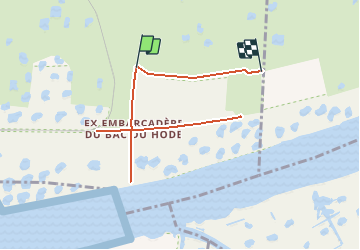
Trail Walking of 8.1 km to be discovered at Normandy, Seine-Maritime, Saint-Vigor-d'Ymonville. This trail is proposed by MarcherEnsemble.
Description
Passer rive gauche par le pont du Hode.
Les cigognes sont dans un espace protégé clos.
Prévoir des jumelles et un téléobjectif, il n'est pas possible de s'approcher très près.
Positioning
Country:
France
Region :
Normandy
Department/Province :
Seine-Maritime
Municipality :
Saint-Vigor-d'Ymonville
Location:
Unknown
Start:(Dec)
Start:(UTM)
309066 ; 5481627 (31U) N.
Comments
Trails nearby
![Trail Walking Saint-Vigor-d'Ymonville - Saint Vigor d'Ymonville - Photo](https://media.geolcdn.com/t/375/260/021f3857-a5d5-44c4-8b19-1adf31301359.jpg&format=jpg&maxdim=2)
![Walking Walking](https://static1.geolcdn.com/sitytour/trail-icons/101.png)
Saint Vigor d'Ymonville
Walking
Medium
(2)
Saint-Vigor-d'Ymonville,
Normandy,
Seine-Maritime,
France
![](/images/other/stat-length.png)
9.6 km | 10.4 km-effort
2h 34min
![](https://static1.geolcdn.com/siteimages/upload/files/16400158638029165_repeat_loop_refresh_sync_direction_icon.png)
Yes
![Trail Walking Fatouville-Grestain - HONFLEUR 07 - Phare de Fatouville (Normandie) - Photo](https://media.geolcdn.com/t/375/260/a9f06c6b-2f5e-41a0-a622-52214993db1a.jpg&format=jpg&maxdim=2)
![Walking Walking](https://static1.geolcdn.com/sitytour/trail-icons/101.png)
HONFLEUR 07 - Phare de Fatouville (Normandie)
Walking
Medium
Fatouville-Grestain,
Normandy,
Eure,
France
![](/images/other/stat-length.png)
14.7 km | 18.3 km-effort
3h 39min
![](https://static1.geolcdn.com/siteimages/upload/files/16400158638029165_repeat_loop_refresh_sync_direction_icon.png)
Yes
![Trail Walking Saint-Samson-de-la-Roque - La Roque - Photo](https://media.geolcdn.com/t/375/260/ext.jpg?maxdim=2&url=https%3A%2F%2Fservices.sitytrail.com%2FGeolivesWS%2FDownloadMedia.ashx%3FTrailID%3D143552%26Media%3D20120804143937.jpg)
![Walking Walking](https://static1.geolcdn.com/sitytour/trail-icons/101.png)
La Roque
Walking
Very easy
Saint-Samson-de-la-Roque,
Normandy,
Eure,
France
![](/images/other/stat-length.png)
14.9 km | 17.7 km-effort
3h 25min
![](https://static1.geolcdn.com/siteimages/upload/files/16400158638029165_repeat_loop_refresh_sync_direction_icon.png)
No
![Trail Walking Sandouville - Sandouville 2023 10 07 - Photo](https://media.geolcdn.com/t/375/260/6695dad7-11b3-4c12-ae95-f4b2d03addac.jpg&format=jpg&maxdim=2)
![Walking Walking](https://static1.geolcdn.com/sitytour/trail-icons/101.png)
Sandouville 2023 10 07
Walking
Very difficult
Sandouville,
Normandy,
Seine-Maritime,
France
![](/images/other/stat-length.png)
21 km | 26 km-effort
5h 49min
![](https://static1.geolcdn.com/siteimages/upload/files/16400158638029165_repeat_loop_refresh_sync_direction_icon.png)
Yes
![Trail Walking La Cerlangue - St Jean d'Abbetot - Photo](https://media.geolcdn.com/t/375/260/31650e47-20be-49a3-ad90-2dea24357470.jpg&format=jpg&maxdim=2)
![Walking Walking](https://static1.geolcdn.com/sitytour/trail-icons/101.png)
St Jean d'Abbetot
Walking
Easy
La Cerlangue,
Normandy,
Seine-Maritime,
France
![](/images/other/stat-length.png)
6.4 km | 6.8 km-effort
1h 46min
![](https://static1.geolcdn.com/siteimages/upload/files/16400158638029165_repeat_loop_refresh_sync_direction_icon.png)
Yes
![On foot On foot](https://static1.geolcdn.com/sitytour/trail-icons/100.png)
berville sur mer
On foot
Very easy
Berville-sur-Mer,
Normandy,
Eure,
France
![](/images/other/stat-length.png)
5.5 km | 6.7 km-effort
Unknown
![](https://static1.geolcdn.com/siteimages/upload/files/16400158638029165_repeat_loop_refresh_sync_direction_icon.png)
Yes
![Trail Walking Conteville - De Conteville aux bords de Seine - Photo](https://media.geolcdn.com/t/375/260/ext.jpg?maxdim=2&url=https%3A%2F%2Fservices.sitytrail.com%2FGeolivesWS%2FDownloadMedia.ashx%3FTrailID%3D129781%26Media%3D13325_1.jpg)
![Walking Walking](https://static1.geolcdn.com/sitytour/trail-icons/101.png)
De Conteville aux bords de Seine
Walking
Medium
Conteville,
Normandy,
Eure,
France
![](/images/other/stat-length.png)
20 km | 24 km-effort
3h 54min
![](https://static1.geolcdn.com/siteimages/upload/files/16400158638029165_repeat_loop_refresh_sync_direction_icon.png)
Yes
![Trail Walking Berville-sur-Mer - Wikiloc - GR®223 Tour du Cotentin (2021) - Photo](https://media.geolcdn.com/t/375/260/ext.jpg?maxdim=2&url=https%3A%2F%2Fstatic1.geolcdn.com%2Fsiteimages%2Fupload%2Ffiles%2F1553511878bg_sport_marche.png)
![Walking Walking](https://static1.geolcdn.com/sitytour/trail-icons/101.png)
Wikiloc - GR®223 Tour du Cotentin (2021)
Walking
Very difficult
Berville-sur-Mer,
Normandy,
Eure,
France
![](/images/other/stat-length.png)
650 km | 737 km-effort
167h 26min
![](https://static1.geolcdn.com/siteimages/upload/files/16400158638029165_repeat_loop_refresh_sync_direction_icon.png)
No
![Trail Walking Berville-sur-Mer - BERVILLE SUR MER - Photo](https://media.geolcdn.com/t/375/260/ext.jpg?maxdim=2&url=https%3A%2F%2Fstatic1.geolcdn.com%2Fsiteimages%2Fupload%2Ffiles%2F1553511878bg_sport_marche.png)
![Walking Walking](https://static1.geolcdn.com/sitytour/trail-icons/101.png)
BERVILLE SUR MER
Walking
Difficult
Berville-sur-Mer,
Normandy,
Eure,
France
![](/images/other/stat-length.png)
11.1 km | 12.9 km-effort
2h 55min
![](https://static1.geolcdn.com/siteimages/upload/files/16400158638029165_repeat_loop_refresh_sync_direction_icon.png)
Yes