![](/images/other/stat-length.png)
![Trail Walking Gros-Chastang - Gorges Dordogne de Gros Chantant via Couffinier et Brigoux - Photo](https://media.geolcdn.com/t/1900/400/ext.pjpeg?maxdim=2&url=https%3A%2F%2Fstatic1.geolcdn.com%2Fsiteimages%2Fupload%2Ffiles%2F1553511878bg_sport_marche.png)
Gorges Dordogne de Gros Chantant via Couffinier et Brigoux
grageot
User
![Length](/images/other/stat-length.png)
Length
11.2 km
![Max alt](https://static1.geolcdn.com/siteimages/upload/files/1508320355ic_sort_altitude_max_24dp.png)
Max alt
539 m
![Uphill gradient](https://static1.geolcdn.com/siteimages/upload/files/1508320355ic_sort_den_pos_24dp.png)
Uphill gradient
322 m
![Km-Effort](/images/other/stat-length.png)
Km-Effort
15.5 km
![Min alt](https://static1.geolcdn.com/siteimages/upload/files/1508320355ic_sort_altitude_min_24dp.png)
Min alt
267 m
![Downhill gradient](https://static1.geolcdn.com/siteimages/upload/files/1508320355ic_sort_den_neg_24dp.png)
Downhill gradient
322 m
![Boucle](https://static1.geolcdn.com/siteimages/upload/files/16400158638029165_repeat_loop_refresh_sync_direction_icon.png)
Boucle
Yes
Creation date :
2017-07-13 00:00:00.0
Updated on :
2017-07-13 00:00:00.0
![Walking](https://static1.geolcdn.com/sitytour/trail-icons/101.png)
2h55
Difficulty : Easy
![Scan this QR Code to open this trail in the SityTrail application](https://capi.geolives.com/qq0zvz2zws4bq2lad0pu/sitytour/trails/787795/qr.png?size=200)
FREE GPS app for hiking
About
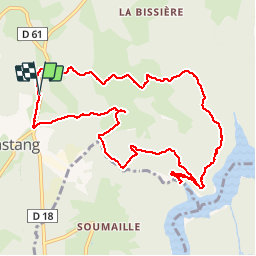
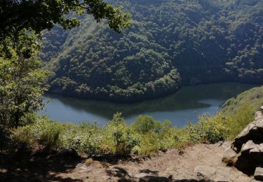
Trail Walking of 11.2 km to be discovered at New Aquitaine, Corrèze, Gros-Chastang. This trail is proposed by grageot.
Description
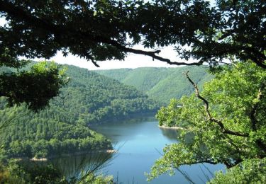
juil 2017-Une ballade facile avec une belle descente jusqu'à l’embarcadère, ne pas hésiter à parcourir les ruelles des 2 hameaux aux jolies maisons corréziennes
Positioning
Country:
France
Region :
New Aquitaine
Department/Province :
Corrèze
Municipality :
Gros-Chastang
Location:
Unknown
Start:(Dec)
Start:(UTM)
421809 ; 5007581 (31T) N.
Comments
Trails nearby
![Trail Mountain bike Marcillac-la-Croisille - Le Jardin de Bardot - Marcillac la Croisille - Pays d'Égletons - Photo](https://media.geolcdn.com/t/375/260/ext.jpg?maxdim=2&url=https%3A%2F%2Fservices.sitytrail.com%2FGeolivesWS%2FDownloadMedia.ashx%3FTrailID%3D112308%26Media%3D10310_1.jpg)
![Mountain bike Mountain bike](https://static1.geolcdn.com/sitytour/trail-icons/202.png)
Le Jardin de Bardot - Marcillac la Croisille - Pays d'Égletons
Mountain bike
Medium
(1)
Marcillac-la-Croisille,
New Aquitaine,
Corrèze,
France
![](/images/other/stat-length.png)
3.6 km | 6 km-effort
30min
![](https://static1.geolcdn.com/siteimages/upload/files/16400158638029165_repeat_loop_refresh_sync_direction_icon.png)
Yes
![Trail Walking Marcillac-la-Croisille - Les Agaries - Marcillac la Croisille - Pays d'Égletons - Photo](https://media.geolcdn.com/t/375/260/ext.jpg?maxdim=2&url=https%3A%2F%2Fservices.sitytrail.com%2FGeolivesWS%2FDownloadMedia.ashx%3FTrailID%3D112309%26Media%3D10311_1.jpg)
![Walking Walking](https://static1.geolcdn.com/sitytour/trail-icons/101.png)
Les Agaries - Marcillac la Croisille - Pays d'Égletons
Walking
Easy
(1)
Marcillac-la-Croisille,
New Aquitaine,
Corrèze,
France
![](/images/other/stat-length.png)
2.7 km | 4.5 km-effort
45min
![](https://static1.geolcdn.com/siteimages/upload/files/16400158638029165_repeat_loop_refresh_sync_direction_icon.png)
Yes
![Trail Walking Gros-Chastang - Observatoires des cerfs - Photo](https://media.geolcdn.com/t/375/260/d1c6f3f2-deed-46bb-8cbe-a462e86c80ae.jpg&format=jpg&maxdim=2)
![Walking Walking](https://static1.geolcdn.com/sitytour/trail-icons/101.png)
Observatoires des cerfs
Walking
Easy
Gros-Chastang,
New Aquitaine,
Corrèze,
France
![](/images/other/stat-length.png)
7.4 km | 8.5 km-effort
3h 11min
![](https://static1.geolcdn.com/siteimages/upload/files/16400158638029165_repeat_loop_refresh_sync_direction_icon.png)
Yes
![Trail Walking Marcillac-la-Croisille - Grand circuit des jardins de Bardot - Photo](https://media.geolcdn.com/t/375/260/c2ae433e-3f6b-486a-8a17-ae1c2834e3d8.jpg&format=jpg&maxdim=2)
![Walking Walking](https://static1.geolcdn.com/sitytour/trail-icons/101.png)
Grand circuit des jardins de Bardot
Walking
Medium
Marcillac-la-Croisille,
New Aquitaine,
Corrèze,
France
![](/images/other/stat-length.png)
14.6 km | 22 km-effort
6h 42min
![](https://static1.geolcdn.com/siteimages/upload/files/16400158638029165_repeat_loop_refresh_sync_direction_icon.png)
Yes
![Trail Walking Marcillac-la-Croisille - Le jardin de Bardot - Photo](https://media.geolcdn.com/t/375/260/c3733c09-734d-4028-9cf2-e28108f2f2c7.jpg&format=jpg&maxdim=2)
![Walking Walking](https://static1.geolcdn.com/sitytour/trail-icons/101.png)
Le jardin de Bardot
Walking
Very easy
Marcillac-la-Croisille,
New Aquitaine,
Corrèze,
France
![](/images/other/stat-length.png)
3.8 km | 6.6 km-effort
1h 58min
![](https://static1.geolcdn.com/siteimages/upload/files/16400158638029165_repeat_loop_refresh_sync_direction_icon.png)
Yes
![Trail Walking Marcillac-la-Croisille - Le Jardin de Bardot - Marcillac la Croisille - Pays d'Égletons - Photo](https://media.geolcdn.com/t/375/260/ext.jpg?maxdim=2&url=https%3A%2F%2Fservices.sitytrail.com%2FGeolivesWS%2FDownloadMedia.ashx%3FTrailID%3D112307%26Media%3D10310_1.jpg)
![Walking Walking](https://static1.geolcdn.com/sitytour/trail-icons/101.png)
Le Jardin de Bardot - Marcillac la Croisille - Pays d'Égletons
Walking
Difficult
Marcillac-la-Croisille,
New Aquitaine,
Corrèze,
France
![](/images/other/stat-length.png)
3.6 km | 6 km-effort
1h 30min
![](https://static1.geolcdn.com/siteimages/upload/files/16400158638029165_repeat_loop_refresh_sync_direction_icon.png)
Yes
![Trail Walking Gumond - t139496961_circuit du doustre et du plateau des etangs - Photo](https://media.geolcdn.com/t/375/260/ext.jpg?maxdim=2&url=https%3A%2F%2Fstatic1.geolcdn.com%2Fsiteimages%2Fupload%2Ffiles%2F1553511878bg_sport_marche.png)
![Walking Walking](https://static1.geolcdn.com/sitytour/trail-icons/101.png)
t139496961_circuit du doustre et du plateau des etangs
Walking
Difficult
Gumond,
New Aquitaine,
Corrèze,
France
![](/images/other/stat-length.png)
11.4 km | 15.3 km-effort
3h 28min
![](https://static1.geolcdn.com/siteimages/upload/files/16400158638029165_repeat_loop_refresh_sync_direction_icon.png)
Yes
![Trail Walking La Roche-Canillac - La Roche-Canillac Moulin de la Grave - Photo](https://media.geolcdn.com/t/375/260/ext.jpg?maxdim=2&url=https%3A%2F%2Fstatic1.geolcdn.com%2Fsiteimages%2Fupload%2Ffiles%2F1553511878bg_sport_marche.png)
![Walking Walking](https://static1.geolcdn.com/sitytour/trail-icons/101.png)
La Roche-Canillac Moulin de la Grave
Walking
Medium
(1)
La Roche-Canillac,
New Aquitaine,
Corrèze,
France
![](/images/other/stat-length.png)
12.5 km | 19.3 km-effort
3h 20min
![](https://static1.geolcdn.com/siteimages/upload/files/16400158638029165_repeat_loop_refresh_sync_direction_icon.png)
Yes
![Trail Walking Champagnac-la-Prune - champagnac la prune - Photo](https://media.geolcdn.com/t/375/260/ext.jpg?maxdim=2&url=https%3A%2F%2Fstatic1.geolcdn.com%2Fsiteimages%2Fupload%2Ffiles%2F1553511878bg_sport_marche.png)
![Walking Walking](https://static1.geolcdn.com/sitytour/trail-icons/101.png)
champagnac la prune
Walking
Medium
Champagnac-la-Prune,
New Aquitaine,
Corrèze,
France
![](/images/other/stat-length.png)
8.3 km | 11 km-effort
3h 8min
![](https://static1.geolcdn.com/siteimages/upload/files/16400158638029165_repeat_loop_refresh_sync_direction_icon.png)
No