Trail Walking Bagnères-de-Bigorre - Lacs de Gresiolles et Campana(GR10c) - Photo

Lacs de Gresiolles et Campana(GR10c)

 Rouzier
Rouzier

User

© OpenStreetMap contributors
Length
Length
16.2 km
Max alt
Max alt
2402 m
Uphill gradient
Uphill gradient
1089 m
Km-Effort
Km-Effort  
31 km
Min alt
Min alt
1423 m
Downhill gradient
Downhill gradient
1092 m
Boucle
Boucle
Yes
Creation date :
2017-07-02 00:00:00.0
Updated on :
2017-07-02 00:00:00.0

(0 Reviews)

Walking
Walking
7h02
Difficulty : Medium

Scan this QR Code to open this trail in the SityTrail application

FREE GPS app for hiking

Logo SityTrail SityTrail

IGN / Geographical institutes

Download SityTrail from the App Store Download SityTrail from Google Play

Logo SityTrail SityTrail World

The world is yours!

Download SityTrail from the App Store Download SityTrail from Google Play Download SityTrail on Huawei AppGallery

About

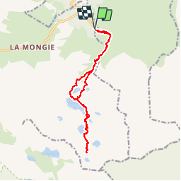
Trail Walking of 16.2 km to be discovered at Occitania, Hautespyrenees, Bagnères-de-Bigorre. This trail is proposed by Rouzier.

Description

Virage duCourets(1423m),croisement GR10c(1558m),réservoir des Laquets,lac et laquette de Grésiolles,lacs Campana, Arredoun,Hourquette et retour par Canderolles.

Elevation profile

Positioning

Country:
France
Region :
Occitania
Department/Province :
Hautespyrenees
Municipality :
Bagnères-de-Bigorre
Location:
Unknown
Start:(UTM)
272216 ; 4755341 (31T) N.

Trails nearby

Trail Walking Campan - Lac d'Arizes - Campan - Photo
Walking
tracegps

Walking

Medium
(1)
Campan, Occitania, Hautespyrenees, France
10.2 km | 20 km-effort
3h 30min
Yes
Trail Walking Ancizan - Vallée de la Gaoube - Photo
Walking
bliguet

Walking

Medium
(1)
Ancizan, Occitania, Hautespyrenees, France
6.6 km | 9.1 km-effort
4h 49min
Yes
Trail Walking Campan - La soula de Tournes - Photo
Walking
GUIDE
LouisROGER

Walking

Easy
(1)
Campan, Occitania, Hautespyrenees, France
7.7 km | 11.3 km-effort
2h 21min
Yes
Trail On foot Campan - SityTrail - 2444920 - artigues-la-mongie-g3-lpc-corrigex - Photo
On foot
JACQUESD

On foot

Very easy
(1)
Campan, Occitania, Hautespyrenees, France
7.8 km | 15.7 km-effort
Unknown
Yes
Trail Walking Campan - artigues à payolle - Photo
Walking
GUIDE
LouisROGER

Walking

Very easy
Campan, Occitania, Hautespyrenees, France
15.1 km | 19.8 km-effort
6h 10min
No
Trail Walking Campan - Pic Midi Bigorres - Photo
Walking
doume82

Walking

Difficult
(1)
Campan, Occitania, Hautespyrenees, France
9.2 km | 25 km-effort
4h 30min
No
Trail Walking Bagnères-de-Bigorre - Sommet TUHOU GRAN 1911m - Photo
Walking
chrisgps

Walking

Difficult
Bagnères-de-Bigorre, Occitania, Hautespyrenees, France
8.4 km | 16.3 km-effort
3h 42min
Yes
Trail Walking Bagnères-de-Bigorre - Lac de Gréziolles - Photo
Walking
HANUCIL

Walking

Medium
Bagnères-de-Bigorre, Occitania, Hautespyrenees, France
10.8 km | 21 km-effort
4h 1min
Yes
Trail Walking Bagnères-de-Bigorre - G2 articles lac de grezillard - Photo
Walking
GUIDE
LouisROGER

Walking

Very difficult
Bagnères-de-Bigorre, Occitania, Hautespyrenees, France
10.4 km | 20 km-effort
7h 18min
Yes


Close
My subscriptions