Trail Mountain bike Gardanne - Boucle Gardanne-Bouc - Photo
 angelo13
angelo13

User

© OpenStreetMap contributors
Length
Length
19.2 km
Max alt
Max alt
330 m
Uphill gradient
Uphill gradient
377 m
Km-Effort
Km-Effort  
24 km
Min alt
Min alt
176 m
Downhill gradient
Downhill gradient
376 m
Boucle
Boucle
Yes
Creation date :
2017-07-02 00:00:00.0
Updated on :
2017-07-02 00:00:00.0

(0 Reviews)

Mountain bike
Mountain bike
1h37
Difficulty : Easy

Scan this QR Code to open this trail in the SityTrail application

FREE GPS app for hiking

Logo SityTrail SityTrail

IGN / Geographical institutes

Download SityTrail from the App Store Download SityTrail from Google Play

Logo SityTrail SityTrail World

The world is yours!

Download SityTrail from the App Store Download SityTrail from Google Play Download SityTrail on Huawei AppGallery

About

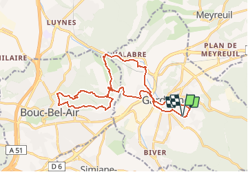
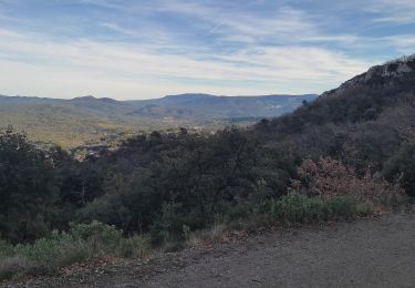
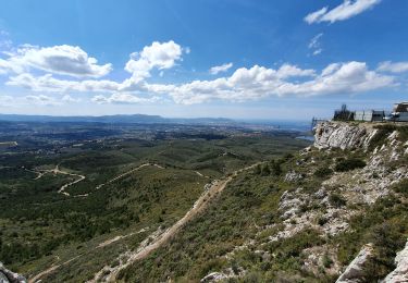
Trail Mountain bike of 19.2 km to be discovered at Provence-Alpes-Côte d'Azur, Bouches-du-Rhône, Gardanne. This trail is proposed by angelo13.

Description

rando facile de 20km entre gardanne et bouc. Depart bd pont de peton (pres du leader price)

Elevation profile

Positioning

Country:
France
Region :
Provence-Alpes-Côte d'Azur
Department/Province :
Bouches-du-Rhône
Municipality :
Gardanne
Location:
Unknown
Start:(UTM)
700606 ; 4813765 (31T) N.

Trails nearby

Trail Walking Simiane-Collongue - chemin de gui - Photo
Walking
rvdebouc

Walking

Easy
(1)
Simiane-Collongue, Provence-Alpes-Côte d'Azur, Bouches-du-Rhône, France
5.9 km | 8.1 km-effort
1h 45min
Yes
Trail Running Bouc-Bel-Air - Balade à Bouc Bel Air - Photo
Running
tracegps

Running

Medium
(1)
Bouc-Bel-Air, Provence-Alpes-Côte d'Azur, Bouches-du-Rhône, France
6.6 km | 8.7 km-effort
34min
Yes
Trail Electric bike Simiane-Collongue - LES MARRES PILON DU ROI - Photo
Electric bike
GUIDE
harydh

Electric bike

Easy
Simiane-Collongue, Provence-Alpes-Côte d'Azur, Bouches-du-Rhône, France
26 km | 36 km-effort
2h 18min
Yes
Trail Walking Saint-Savournin - St Savourin Col Ste Anne - Photo
Walking
sereton

Walking

Medium
Saint-Savournin, Provence-Alpes-Côte d'Azur, Bouches-du-Rhône, France
9.2 km | 15.2 km-effort
2h 59min
Yes
Trail Walking Mimet - Massif de l'Etoile: Col Ste Anne, Pilon, Col des Ouides - Photo
Walking
phidge

Walking

Very difficult
(1)
Mimet, Provence-Alpes-Côte d'Azur, Bouches-du-Rhône, France
12.3 km | 19.4 km-effort
4h 49min
Yes
Trail Walking Mimet - le Baou traouca et la grotte des fées - Photo
Walking
GUIDE
amiral13

Walking

Medium
Mimet, Provence-Alpes-Côte d'Azur, Bouches-du-Rhône, France
11.2 km | 17.7 km-effort
5h 11min
Yes
Trail Walking Mimet - la chaîne de l'étoile au départ du col Sainte-Anne - Photo
Walking
GUIDE
amiral13

Walking

Difficult
Mimet, Provence-Alpes-Côte d'Azur, Bouches-du-Rhône, France
16.2 km | 25 km-effort
5h 58min
Yes
Trail Walking Simiane-Collongue - SityTrail - Etoile-Petit Sanguin - Photo
Walking
MicDul

Walking

Simiane-Collongue, Provence-Alpes-Côte d'Azur, Bouches-du-Rhône, France
14.8 km | 21 km-effort
4h 43min
Yes
Trail Walking Simiane-Collongue - De Simiane-Collongue au Pilon du Roi - Photo
Walking
LtZIP

Walking

Medium
Simiane-Collongue, Provence-Alpes-Côte d'Azur, Bouches-du-Rhône, France
13.6 km | 23 km-effort
4h 44min
No


Close
My subscriptions