![](/images/other/stat-length.png)
![Trail Walking Comps - Comps et col de la Pousterle - Photo](https://media.geolcdn.com/t/1900/400/ext.pjpeg?maxdim=2&url=https%3A%2F%2Fservices.sitytrail.com%2FGeolivesWS%2FDownloadMedia.ashx%3FTrailID%3D782781%26Media%3Dfix__20170702181413.jpg)
Comps et col de la Pousterle
rcu3824
User
![Length](/images/other/stat-length.png)
Length
9.8 km
![Max alt](https://static1.geolcdn.com/siteimages/upload/files/1508320355ic_sort_altitude_max_24dp.png)
Max alt
927 m
![Uphill gradient](https://static1.geolcdn.com/siteimages/upload/files/1508320355ic_sort_den_pos_24dp.png)
Uphill gradient
519 m
![Km-Effort](/images/other/stat-length.png)
Km-Effort
16.8 km
![Min alt](https://static1.geolcdn.com/siteimages/upload/files/1508320355ic_sort_altitude_min_24dp.png)
Min alt
474 m
![Downhill gradient](https://static1.geolcdn.com/siteimages/upload/files/1508320355ic_sort_den_neg_24dp.png)
Downhill gradient
527 m
![Boucle](https://static1.geolcdn.com/siteimages/upload/files/16400158638029165_repeat_loop_refresh_sync_direction_icon.png)
Boucle
Yes
Creation date :
2017-07-04 00:00:00.0
Updated on :
2017-07-04 00:00:00.0
![Walking](https://static1.geolcdn.com/sitytour/trail-icons/101.png)
3h25
Difficulty : Easy
![Scan this QR Code to open this trail in the SityTrail application](https://capi.geolives.com/qq0zvz2zws4bq2lad0pu/sitytour/trails/782781/qr.png?size=200)
FREE GPS app for hiking
About
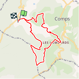
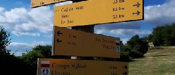
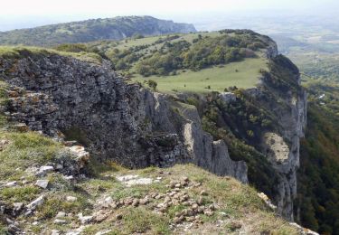
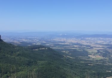
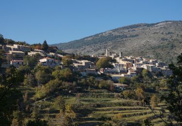
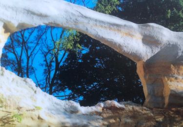
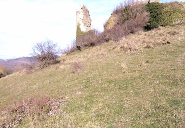
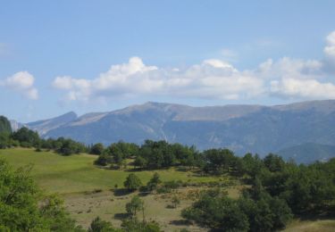
Trail Walking of 9.8 km to be discovered at Auvergne-Rhône-Alpes, Drôme, Comps. This trail is proposed by rcu3824.
Description
Bonne grimpette pour aller au col. Départ et arrivée au camping. Raccourci après église de Comps pas terrible. Prendre plutôt la route qui passe par la mairie de Comps.
Positioning
Country:
France
Region :
Auvergne-Rhône-Alpes
Department/Province :
Drôme
Municipality :
Comps
Location:
Unknown
Start:(Dec)
Start:(UTM)
665848 ; 4935280 (31T) N.
Comments
Trails nearby
![Trail Walking Montjoux - Le Devès - Montjoux - Photo](https://media.geolcdn.com/t/375/260/ext.jpg?maxdim=2&url=https%3A%2F%2Fservices.sitytrail.com%2FGeolivesWS%2FDownloadMedia.ashx%3FTrailID%3D172804%26Media%3D14234_5.jpg)
![Walking Walking](https://static1.geolcdn.com/sitytour/trail-icons/101.png)
Le Devès - Montjoux
Walking
Easy
(1)
Montjoux,
Auvergne-Rhône-Alpes,
Drôme,
France
![](/images/other/stat-length.png)
5.3 km | 7 km-effort
1h 19min
![](https://static1.geolcdn.com/siteimages/upload/files/16400158638029165_repeat_loop_refresh_sync_direction_icon.png)
Yes
![Trail Walking Dieulefit - 26 dieulefit chap st Maurice vitrouilleres - Photo](https://media.geolcdn.com/t/375/260/9032ba92-359b-417c-8863-3a326ab807ba.jpg&format=jpg&maxdim=2)
![Walking Walking](https://static1.geolcdn.com/sitytour/trail-icons/101.png)
26 dieulefit chap st Maurice vitrouilleres
Walking
Easy
Dieulefit,
Auvergne-Rhône-Alpes,
Drôme,
France
![](/images/other/stat-length.png)
13.8 km | 23 km-effort
6h 17min
![](https://static1.geolcdn.com/siteimages/upload/files/16400158638029165_repeat_loop_refresh_sync_direction_icon.png)
Yes
![Trail Walking Rochebaudin - Rochebaudin-Trou du Furet-Serre Gros 16km - Photo](https://media.geolcdn.com/t/375/260/dc7160ec-c951-47bb-8de8-e15fab760352.jpg&format=jpg&maxdim=2)
![Walking Walking](https://static1.geolcdn.com/sitytour/trail-icons/101.png)
Rochebaudin-Trou du Furet-Serre Gros 16km
Walking
Difficult
Rochebaudin,
Auvergne-Rhône-Alpes,
Drôme,
France
![](/images/other/stat-length.png)
15.8 km | 26 km-effort
5h 0min
![](https://static1.geolcdn.com/siteimages/upload/files/16400158638029165_repeat_loop_refresh_sync_direction_icon.png)
Yes
![Trail Walking Dieulefit - 2022-09-03_11h50m30_Chapelle St Maurice 10km.gpx (3).xml - Photo](https://media.geolcdn.com/t/375/260/70a2cb51-e6fc-4007-ba36-e4a050e05f72.jpg&format=jpg&maxdim=2)
![Walking Walking](https://static1.geolcdn.com/sitytour/trail-icons/101.png)
2022-09-03_11h50m30_Chapelle St Maurice 10km.gpx (3).xml
Walking
Difficult
Dieulefit,
Auvergne-Rhône-Alpes,
Drôme,
France
![](/images/other/stat-length.png)
10 km | 17.1 km-effort
3h 53min
![](https://static1.geolcdn.com/siteimages/upload/files/16400158638029165_repeat_loop_refresh_sync_direction_icon.png)
Yes
![Trail Walking Dieulefit - Chapelle saint Maurice par le sentier du cochon - Photo](https://media.geolcdn.com/t/375/260/cf0b1613-8f56-44df-807b-db512561a354.jpg&format=jpg&maxdim=2)
![Walking Walking](https://static1.geolcdn.com/sitytour/trail-icons/101.png)
Chapelle saint Maurice par le sentier du cochon
Walking
Difficult
Dieulefit,
Auvergne-Rhône-Alpes,
Drôme,
France
![](/images/other/stat-length.png)
10.9 km | 17.9 km-effort
4h 40min
![](https://static1.geolcdn.com/siteimages/upload/files/16400158638029165_repeat_loop_refresh_sync_direction_icon.png)
Yes
![Trail Walking Comps - 2024-03-07_12h38m09_Orcinas 14km - Photo](https://media.geolcdn.com/t/375/260/d29c1d85-ffea-4497-9bab-1cce45a06780.jpg&format=jpg&maxdim=2)
![Walking Walking](https://static1.geolcdn.com/sitytour/trail-icons/101.png)
2024-03-07_12h38m09_Orcinas 14km
Walking
Very difficult
Comps,
Auvergne-Rhône-Alpes,
Drôme,
France
![](/images/other/stat-length.png)
14.1 km | 22 km-effort
4h 54min
![](https://static1.geolcdn.com/siteimages/upload/files/16400158638029165_repeat_loop_refresh_sync_direction_icon.png)
Yes
![Trail Walking Dieulefit - Vitrouillières Dieulefit - Photo](https://media.geolcdn.com/t/375/260/11bc24d8-15a9-487b-bcda-b3a093eafbe9.jpg&format=jpg&maxdim=2)
![Walking Walking](https://static1.geolcdn.com/sitytour/trail-icons/101.png)
Vitrouillières Dieulefit
Walking
Medium
Dieulefit,
Auvergne-Rhône-Alpes,
Drôme,
France
![](/images/other/stat-length.png)
14.8 km | 25 km-effort
4h 28min
![](https://static1.geolcdn.com/siteimages/upload/files/16400158638029165_repeat_loop_refresh_sync_direction_icon.png)
Yes
![Trail Walking Bourdeaux - 26 bourreaux huguenot 31.12.22 - Photo](https://media.geolcdn.com/t/375/260/d3bd89ec-167b-4d96-a78d-b5b047518271.jpg&format=jpg&maxdim=2)
![Walking Walking](https://static1.geolcdn.com/sitytour/trail-icons/101.png)
26 bourreaux huguenot 31.12.22
Walking
Medium
Bourdeaux,
Auvergne-Rhône-Alpes,
Drôme,
France
![](/images/other/stat-length.png)
15 km | 23 km-effort
5h 45min
![](https://static1.geolcdn.com/siteimages/upload/files/16400158638029165_repeat_loop_refresh_sync_direction_icon.png)
No
![Trail Walking Dieulefit - 2022-09-03_11h49m50_Tour des 3 montagnes 18km.gpx.xml - Photo](https://media.geolcdn.com/t/375/260/14536835-7996-47e3-9b26-05b81d5d9fd5.jpg&format=jpg&maxdim=2)
![Walking Walking](https://static1.geolcdn.com/sitytour/trail-icons/101.png)
2022-09-03_11h49m50_Tour des 3 montagnes 18km.gpx.xml
Walking
Difficult
Dieulefit,
Auvergne-Rhône-Alpes,
Drôme,
France
![](/images/other/stat-length.png)
18 km | 26 km-effort
5h 50min
![](https://static1.geolcdn.com/siteimages/upload/files/16400158638029165_repeat_loop_refresh_sync_direction_icon.png)
Yes