Trail Via ferrata Roussines - Prospection RU -A-C-BOULOU - Photo

Prospection RU -A-C-BOULOU

Recherche Utilitaire

© OpenStreetMap contributors
Length
Length
101 km
Max alt
Max alt
294 m
Uphill gradient
Uphill gradient
1286 m
Km-Effort
Km-Effort  
119 km
Min alt
Min alt
62 m
Downhill gradient
Downhill gradient
1443 m
Boucle
Boucle
No
Creation date :
2017-06-26 00:00:00.0
Updated on :
2024-10-21 09:14:26.53

(0 Reviews)

Via ferrata
Via ferrata
13h14
Difficulty : Unknown

Scan this QR Code to open this trail in the SityTrail application

FREE GPS app for hiking

Logo SityTrail SityTrail

IGN / Geographical institutes

Download SityTrail from the App Store Download SityTrail from Google Play

Logo SityTrail SityTrail World

The world is yours!

Download SityTrail from the App Store Download SityTrail from Google Play Download SityTrail on Huawei AppGallery

About

Trail Via ferrata of 101 km to be discovered at New Aquitaine, Charente, Roussines. This trail is proposed by Amicale Canine du Boulou.

Elevation profile

Positioning

Country:
France
Region :
New Aquitaine
Department/Province :
Charente
Municipality :
Roussines
Location:
Unknown
Start:(UTM)
313433 ; 5065409 (31T) N.

Trails nearby

Trail Walking Le Lindois - La balade du Lindois - Photo
Walking
alainjoseph6

Walking

Easy
Le Lindois, New Aquitaine, Charente, France
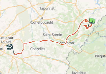
9.7 km | 11.6 km-effort
3h 3min
Yes
Trail Walking Roussines - Roussines et la vallée de Montizon - Photo
Walking
alainjoseph6

Walking

Easy
Roussines, New Aquitaine, Charente, France
10.7 km | 13.1 km-effort
2h 50min
Yes
Trail Mountain bike Roussines - T02-Roussines à Massignac - Photo
Mountain bike
topolino

Mountain bike

Very easy
Roussines, New Aquitaine, Charente, France
17.4 km | 21 km-effort
Unknown
No
Trail Horseback riding Écuras - après midi 30 - Photo
Horseback riding
Dom4i

Horseback riding

Very easy
Écuras, New Aquitaine, Charente, France
12.1 km | 16.2 km-effort
2h 3min
No


Close
My subscriptions