Trail Cycle Domodossola - Venetië dag 17 - Photo
© OpenStreetMap contributors
Length
Length
53 km
Max alt
Max alt
323 m
Uphill gradient
Uphill gradient
553 m
Km-Effort
Km-Effort  
60 km
Min alt
Min alt
190 m
Downhill gradient
Downhill gradient
488 m
Boucle
Boucle
No
Creation date :
2017-06-14 00:00:00.0
Updated on :
2017-06-14 00:00:00.0

(0 Reviews)

Cycle
Cycle
3h53
Difficulty : Easy

Scan this QR Code to open this trail in the SityTrail application

FREE GPS app for hiking

Logo SityTrail SityTrail

IGN / Geographical institutes

Download SityTrail from the App Store Download SityTrail from Google Play

Logo SityTrail SityTrail World

The world is yours!

Download SityTrail from the App Store Download SityTrail from Google Play Download SityTrail on Huawei AppGallery

About

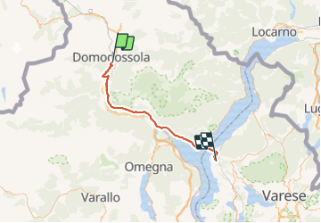
Trail Cycle of 53 km to be discovered at Piemont, Verbano-Cusio-Ossola, Domodossola. This trail is proposed by karawatsj.

Description

Van Piemonte naar Lombardije via Lago Magiorre

Elevation profile

Photos

Positioning

Country:
Italy
Region :
Piemont
Department/Province :
Verbano-Cusio-Ossola
Municipality :
Domodossola
Location:
Unknown
Start:(UTM)
445654 ; 5105691 (32T) N.

Trails nearby

Trail On foot Masera - M00a - Via del Mercato (variante per Trontano) - Photo
On foot
GUIDE+

On foot

Easy
Masera, Piemont, Verbano-Cusio-Ossola, Italy
7.5 km | 12.4 km-effort
2h 49min
No
Trail On foot Masera - M00 - Via del Mercato tappa 1 - Photo
On foot
GUIDE+

On foot

Medium
Masera, Piemont, Verbano-Cusio-Ossola, Italy
18.8 km | 30 km-effort
6h 48min
No
Trail On foot Masera - A08 - Masera località Ranco - Alpe Pescia - Photo
On foot
GUIDE+

On foot

Easy
Masera, Piemont, Verbano-Cusio-Ossola, Italy
4.5 km | 13.2 km-effort
2h 59min
No
Trail On foot Trontano - A16 - Trontano - Passo del Ragozzale - Photo
On foot
GUIDE+

On foot

Medium
Trontano, Piemont, Verbano-Cusio-Ossola, Italy
9.2 km | 24 km-effort
5h 31min
No
Trail On foot Trontano - A14 - Verigo - Passo di Basagrana - Photo
On foot
GUIDE+

On foot

Medium
Trontano, Piemont, Verbano-Cusio-Ossola, Italy
7.7 km | 23 km-effort
5h 7min
No
Trail On foot Masera - A06 - Masera - Alpe Pescia - Photo
On foot
GUIDE+

On foot

Easy
Masera, Piemont, Verbano-Cusio-Ossola, Italy
6.6 km | 17.4 km-effort
3h 56min
No
Trail On foot Beura-Cardezza - A20 - Beura - Punta Pozzolo - Photo
On foot
GUIDE+

On foot

Medium
Beura-Cardezza, Piemont, Verbano-Cusio-Ossola, Italy
7.6 km | 26 km-effort
5h 48min
No
Trail On foot Domodossola - A01 - La Via Alta - Photo
On foot
GUIDE+

On foot

Easy
Domodossola, Piemont, Verbano-Cusio-Ossola, Italy
7.8 km | 12.9 km-effort
2h 56min
No
Trail On foot Villadossola - A03 - Villadossola - Colletto Moncucco - Photo
On foot
GUIDE+

On foot

Medium
Villadossola, Piemont, Verbano-Cusio-Ossola, Italy
8.2 km | 24 km-effort
5h 28min
No


Close
My subscriptions