![](/images/other/stat-length.png)
![Trail Mountain bike Houthalen-Helchteren - B.Houthalen63A53.226VTT1 - Photo](https://media.geolcdn.com/t/1900/400/ext.pjpeg?maxdim=2&url=https%3A%2F%2Fstatic1.geolcdn.com%2Fsiteimages%2Fupload%2Ffiles%2F1524743154velo.jpg)
B.Houthalen63A53.226VTT1
francois58
User
![Length](/images/other/stat-length.png)
![Max alt](https://static1.geolcdn.com/siteimages/upload/files/1508320355ic_sort_altitude_max_24dp.png)
![Uphill gradient](https://static1.geolcdn.com/siteimages/upload/files/1508320355ic_sort_den_pos_24dp.png)
![Km-Effort](/images/other/stat-length.png)
![Min alt](https://static1.geolcdn.com/siteimages/upload/files/1508320355ic_sort_altitude_min_24dp.png)
![Downhill gradient](https://static1.geolcdn.com/siteimages/upload/files/1508320355ic_sort_den_neg_24dp.png)
![Boucle](https://static1.geolcdn.com/siteimages/upload/files/16400158638029165_repeat_loop_refresh_sync_direction_icon.png)
![Mountain bike](https://static1.geolcdn.com/sitytour/trail-icons/202.png)
3h51
Difficulty : Easy
![Scan this QR Code to open this trail in the SityTrail application](https://capi.geolives.com/qq0zvz2zws4bq2lad0pu/sitytour/trails/770496/qr.png?size=200)
FREE GPS app for hiking
About
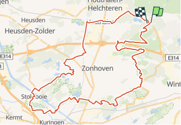
Trail Mountain bike of 53 km to be discovered at Flanders, Limburg, Houthalen-Helchteren. This trail is proposed by francois58.
Description
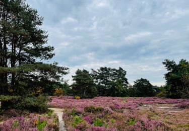
Belle boucle variée dans les landes de bruyères et les étangs de Wijers.
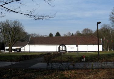
Passage étonnant au ras de l'eau à Bokrij, belle abbaye d'Herkenrode et tour d'observation sur les étangs .... entre autres !
Le VTT est recommandé ... même si le VTC passera moyennant quelques portages dans le sable sur le tronçon avant Bokrijk.
Points of interest
Positioning
Comments
Trails nearby
![Trail Walking Zonhoven - de-wijers-de-teut-instapplaats-donderslagseweg-blauw - Photo](https://media.geolcdn.com/t/375/260/b2e8aeaf-7e73-4433-bd25-55a9739e6f87.jpeg&format=jpg&maxdim=2)
![Walking Walking](https://static1.geolcdn.com/sitytour/trail-icons/101.png)
Walking
![](/images/other/stat-length.png)
![](https://static1.geolcdn.com/siteimages/upload/files/16400158638029165_repeat_loop_refresh_sync_direction_icon.png)
![Trail On foot Houthalen-Helchteren - Wilgenwandeling Vallei Mangelbeek - Photo](https://media.geolcdn.com/t/375/260/3c7aa2d3-ecda-47f4-a3e5-c4f83c20820c.jpeg&format=jpg&maxdim=2)
![On foot On foot](https://static1.geolcdn.com/sitytour/trail-icons/100.png)
On foot
![](/images/other/stat-length.png)
![](https://static1.geolcdn.com/siteimages/upload/files/16400158638029165_repeat_loop_refresh_sync_direction_icon.png)
![Trail On foot Houthalen-Helchteren - Het land van bier, melk en honing Rode driehoek - Photo](https://media.geolcdn.com/t/375/260/c7ff7216-ba82-4f40-8ea0-2f928bb9a895.jpeg&format=jpg&maxdim=2)
![On foot On foot](https://static1.geolcdn.com/sitytour/trail-icons/100.png)
On foot
![](/images/other/stat-length.png)
![](https://static1.geolcdn.com/siteimages/upload/files/16400158638029165_repeat_loop_refresh_sync_direction_icon.png)
![Trail On foot Houthalen-Helchteren - Het land van bier, melk en honing Gele zeshoek - Photo](https://media.geolcdn.com/t/375/260/c7ff7216-ba82-4f40-8ea0-2f928bb9a895.jpeg&format=jpg&maxdim=2)
![On foot On foot](https://static1.geolcdn.com/sitytour/trail-icons/100.png)
On foot
![](/images/other/stat-length.png)
![](https://static1.geolcdn.com/siteimages/upload/files/16400158638029165_repeat_loop_refresh_sync_direction_icon.png)
![Trail On foot Houthalen-Helchteren - Kelchterhoef Blauwe ruit - Photo](https://media.geolcdn.com/t/375/260/607a7d4c-26ee-4efc-8e48-7bf7b864aabc.jpeg&format=jpg&maxdim=2)
![On foot On foot](https://static1.geolcdn.com/sitytour/trail-icons/100.png)
On foot
![](/images/other/stat-length.png)
![](https://static1.geolcdn.com/siteimages/upload/files/16400158638029165_repeat_loop_refresh_sync_direction_icon.png)
![Trail On foot Houthalen-Helchteren - Kelchterhoef Gele zeshoek - Photo](https://media.geolcdn.com/t/375/260/607a7d4c-26ee-4efc-8e48-7bf7b864aabc.jpeg&format=jpg&maxdim=2)
![On foot On foot](https://static1.geolcdn.com/sitytour/trail-icons/100.png)
On foot
![](/images/other/stat-length.png)
![](https://static1.geolcdn.com/siteimages/upload/files/16400158638029165_repeat_loop_refresh_sync_direction_icon.png)
![Trail On foot Houthalen-Helchteren - Kelchterhoef Oranje bol - Photo](https://media.geolcdn.com/t/375/260/49dcc599-2463-4f59-8ee4-11e855da3936.jpeg&format=jpg&maxdim=2)
![On foot On foot](https://static1.geolcdn.com/sitytour/trail-icons/100.png)
On foot
![](/images/other/stat-length.png)
![](https://static1.geolcdn.com/siteimages/upload/files/16400158638029165_repeat_loop_refresh_sync_direction_icon.png)
![Trail Walking Genk - 2021-03-01_18h19m00_1064 - Photo](https://media.geolcdn.com/t/375/260/0f01ba13-08ba-4091-8289-741eb85bca4a.jpg&format=jpg&maxdim=2)
![Walking Walking](https://static1.geolcdn.com/sitytour/trail-icons/101.png)
Walking
![](/images/other/stat-length.png)
![](https://static1.geolcdn.com/siteimages/upload/files/16400158638029165_repeat_loop_refresh_sync_direction_icon.png)
![Trail Walking Zonhoven - Zonhoven (De Teut) - Photo](https://media.geolcdn.com/t/375/260/6221ad09-d265-46cc-a2f6-86f3dccecec7.jpg&format=jpg&maxdim=2)
![Walking Walking](https://static1.geolcdn.com/sitytour/trail-icons/101.png)
Walking
![](/images/other/stat-length.png)
![](https://static1.geolcdn.com/siteimages/upload/files/16400158638029165_repeat_loop_refresh_sync_direction_icon.png)