![](/images/other/stat-length.png)
![Trail Mountain bike Longuyon - Longuyon 1 Rando VTT ou Marche Courte 6,2 km - Photo](https://media.geolcdn.com/t/1900/400/ext.pjpeg?maxdim=2&url=https%3A%2F%2Fstatic1.geolcdn.com%2Fsiteimages%2Fupload%2Ffiles%2F1524743154velo.jpg)
Longuyon 1 Rando VTT ou Marche Courte 6,2 km
dom54400
User
![Length](/images/other/stat-length.png)
Length
6.2 km
![Max alt](https://static1.geolcdn.com/siteimages/upload/files/1508320355ic_sort_altitude_max_24dp.png)
Max alt
303 m
![Uphill gradient](https://static1.geolcdn.com/siteimages/upload/files/1508320355ic_sort_den_pos_24dp.png)
Uphill gradient
121 m
![Km-Effort](/images/other/stat-length.png)
Km-Effort
7.8 km
![Min alt](https://static1.geolcdn.com/siteimages/upload/files/1508320355ic_sort_altitude_min_24dp.png)
Min alt
209 m
![Downhill gradient](https://static1.geolcdn.com/siteimages/upload/files/1508320355ic_sort_den_neg_24dp.png)
Downhill gradient
119 m
![Boucle](https://static1.geolcdn.com/siteimages/upload/files/16400158638029165_repeat_loop_refresh_sync_direction_icon.png)
Boucle
Yes
Creation date :
2017-06-09 00:00:00.0
Updated on :
2017-06-09 00:00:00.0
![Mountain bike](https://static1.geolcdn.com/sitytour/trail-icons/202.png)
32m
Difficulty : Medium
![Scan this QR Code to open this trail in the SityTrail application](https://capi.geolives.com/qq0zvz2zws4bq2lad0pu/sitytour/trails/769519/qr.png?size=200)
FREE GPS app for hiking
About
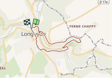
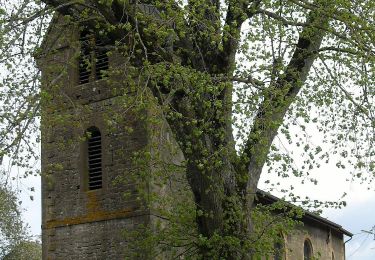
Trail Mountain bike of 6.2 km to be discovered at Grand Est, Meurthe-et-Moselle, Longuyon. This trail is proposed by dom54400.
Description
Randonnée VTT Courte à Longuyon En Lorraine, découverte de la ville et de la nature autour, passage par l'étang de profonde Fontaine et le centre ville, plusieurs pont au dessus de la Crusnes
Positioning
Country:
France
Region :
Grand Est
Department/Province :
Meurthe-et-Moselle
Municipality :
Longuyon
Location:
Unknown
Start:(Dec)
Start:(UTM)
688435 ; 5480499 (31U) N.
Comments
Trails nearby
![Trail On foot Longuyon - Circuit de Revémont - Photo](https://media.geolcdn.com/t/375/260/f21452ab-062e-4bf2-96f0-8115e60adf9c.jpeg&format=jpg&maxdim=2)
![On foot On foot](https://static1.geolcdn.com/sitytour/trail-icons/100.png)
Circuit de Revémont
On foot
Easy
Longuyon,
Grand Est,
Meurthe-et-Moselle,
France
![](/images/other/stat-length.png)
10.1 km | 12.3 km-effort
2h 48min
![](https://static1.geolcdn.com/siteimages/upload/files/16400158638029165_repeat_loop_refresh_sync_direction_icon.png)
No
![Trail On foot Longuyon - Quatre Fermes - Photo](https://media.geolcdn.com/t/375/260/98ea0501-e137-466e-a7aa-132803d0ec62.jpeg&format=jpg&maxdim=2)
![On foot On foot](https://static1.geolcdn.com/sitytour/trail-icons/100.png)
Quatre Fermes
On foot
Medium
Longuyon,
Grand Est,
Meurthe-et-Moselle,
France
![](/images/other/stat-length.png)
18.5 km | 23 km-effort
5h 10min
![](https://static1.geolcdn.com/siteimages/upload/files/16400158638029165_repeat_loop_refresh_sync_direction_icon.png)
Yes
![Trail On foot Longuyon - Circuilaire du Limaçon - Photo](https://media.geolcdn.com/t/375/260/a5b89b0f-547e-4d5c-a3a5-9ced22e0ee49.jpeg&format=jpg&maxdim=2)
![On foot On foot](https://static1.geolcdn.com/sitytour/trail-icons/100.png)
Circuilaire du Limaçon
On foot
Easy
Longuyon,
Grand Est,
Meurthe-et-Moselle,
France
![](/images/other/stat-length.png)
8.8 km | 11.9 km-effort
2h 42min
![](https://static1.geolcdn.com/siteimages/upload/files/16400158638029165_repeat_loop_refresh_sync_direction_icon.png)
Yes
![Trail On foot Grand-Failly - Circuit des Épis d'Or - Photo](https://media.geolcdn.com/t/375/260/fefa0d98-3004-404d-8c64-471b3dc22ff9.jpeg&format=jpg&maxdim=2)
![On foot On foot](https://static1.geolcdn.com/sitytour/trail-icons/100.png)
Circuit des Épis d'Or
On foot
Easy
Grand-Failly,
Grand Est,
Meurthe-et-Moselle,
France
![](/images/other/stat-length.png)
12.4 km | 15.1 km-effort
3h 25min
![](https://static1.geolcdn.com/siteimages/upload/files/16400158638029165_repeat_loop_refresh_sync_direction_icon.png)
Yes
![Trail On foot Viviers-sur-Chiers - CV Longuyon Verte - Photo](https://media.geolcdn.com/t/375/260/44260bb7-9052-40d4-a103-929e25068bc2.jpeg&format=jpg&maxdim=2)
![On foot On foot](https://static1.geolcdn.com/sitytour/trail-icons/100.png)
CV Longuyon Verte
On foot
Easy
Viviers-sur-Chiers,
Grand Est,
Meurthe-et-Moselle,
France
![](/images/other/stat-length.png)
3.2 km | 3.7 km-effort
50min
![](https://static1.geolcdn.com/siteimages/upload/files/16400158638029165_repeat_loop_refresh_sync_direction_icon.png)
No
![Trail Walking Villette - Villette 19-05-23 - Photo](https://media.geolcdn.com/t/375/260/bdcbc3e4-4232-4efc-a22d-8c8ed8a923cc.jpg&format=jpg&maxdim=2)
![Walking Walking](https://static1.geolcdn.com/sitytour/trail-icons/101.png)
Villette 19-05-23
Walking
Easy
Villette,
Grand Est,
Meurthe-et-Moselle,
France
![](/images/other/stat-length.png)
3.9 km | 4.4 km-effort
59min
![](https://static1.geolcdn.com/siteimages/upload/files/16400158638029165_repeat_loop_refresh_sync_direction_icon.png)
Yes
![Trail On foot Longuyon - moncel 9.01.2024 - Photo](https://media.geolcdn.com/t/375/260/ext.jpg?maxdim=2&url=https%3A%2F%2Fstatic1.geolcdn.com%2Fsiteimages%2Fupload%2Ffiles%2F1545311037marcheuse_200dpi.jpg)
![On foot On foot](https://static1.geolcdn.com/sitytour/trail-icons/100.png)
moncel 9.01.2024
On foot
Easy
Longuyon,
Grand Est,
Meurthe-et-Moselle,
France
![](/images/other/stat-length.png)
6.8 km | 8.3 km-effort
1h 53min
![](https://static1.geolcdn.com/siteimages/upload/files/16400158638029165_repeat_loop_refresh_sync_direction_icon.png)
Yes
![Trail On foot Longuyon - beaujolais cv 21.11.2024 - Photo](https://media.geolcdn.com/t/375/260/ext.jpg?maxdim=2&url=https%3A%2F%2Fstatic1.geolcdn.com%2Fsiteimages%2Fupload%2Ffiles%2F1545311037marcheuse_200dpi.jpg)
![On foot On foot](https://static1.geolcdn.com/sitytour/trail-icons/100.png)
beaujolais cv 21.11.2024
On foot
Easy
(1)
Longuyon,
Grand Est,
Meurthe-et-Moselle,
France
![](/images/other/stat-length.png)
5.8 km | 8.1 km-effort
1h 50min
![](https://static1.geolcdn.com/siteimages/upload/files/16400158638029165_repeat_loop_refresh_sync_direction_icon.png)
Yes
![Trail On foot Saint-Laurent-sur-Othain - rond fontaine - Photo](https://media.geolcdn.com/t/375/260/ext.jpg?maxdim=2&url=https%3A%2F%2Fstatic1.geolcdn.com%2Fsiteimages%2Fupload%2Ffiles%2F1545311037marcheuse_200dpi.jpg)
![On foot On foot](https://static1.geolcdn.com/sitytour/trail-icons/100.png)
rond fontaine
On foot
Easy
Saint-Laurent-sur-Othain,
Grand Est,
Meuse,
France
![](/images/other/stat-length.png)
8.3 km | 9.9 km-effort
2h 15min
![](https://static1.geolcdn.com/siteimages/upload/files/16400158638029165_repeat_loop_refresh_sync_direction_icon.png)
Yes