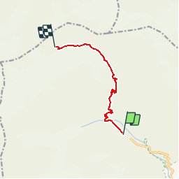
![](/images/other/stat-length.png)
![Trail Walking Vallouise-Pelvoux - REFUGE DES ECRINS.01 10 13 - Photo](https://media.geolcdn.com/t/1900/400/ext.pjpeg?maxdim=2&url=https%3A%2F%2Fstatic1.geolcdn.com%2Fsiteimages%2Fupload%2Ffiles%2F1553511878bg_sport_marche.png)
REFUGE DES ECRINS.01 10 13
Dervalmarc
User
![Length](/images/other/stat-length.png)
![Max alt](https://static1.geolcdn.com/siteimages/upload/files/1508320355ic_sort_altitude_max_24dp.png)
![Uphill gradient](https://static1.geolcdn.com/siteimages/upload/files/1508320355ic_sort_den_pos_24dp.png)
![Km-Effort](/images/other/stat-length.png)
![Min alt](https://static1.geolcdn.com/siteimages/upload/files/1508320355ic_sort_altitude_min_24dp.png)
![Downhill gradient](https://static1.geolcdn.com/siteimages/upload/files/1508320355ic_sort_den_neg_24dp.png)
![Boucle](https://static1.geolcdn.com/siteimages/upload/files/16400158638029165_repeat_loop_refresh_sync_direction_icon.png)
![Walking](https://static1.geolcdn.com/sitytour/trail-icons/101.png)
4h45
Difficulty : Difficult
![Scan this QR Code to open this trail in the SityTrail application](https://capi.geolives.com/qq0zvz2zws4bq2lad0pu/sitytour/trails/762051/qr.png?size=200)
FREE GPS app for hiking
About
Trail Walking of 7.2 km to be discovered at Provence-Alpes-Côte d'Azur, Hautes-Alpes, Vallouise-Pelvoux. This trail is proposed by Dervalmarc.
Description
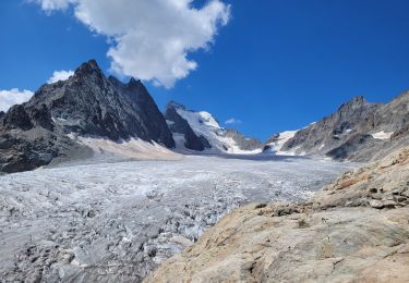
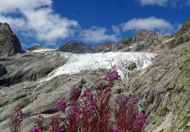
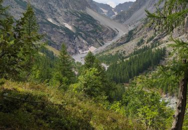
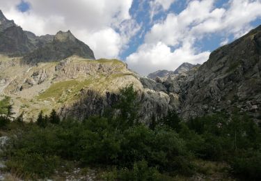
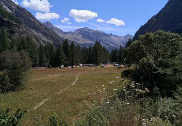
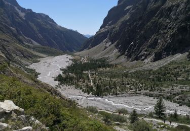
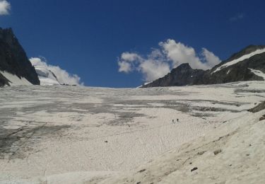
Le refuge des Écrins, appelé aussi refuge Caron est situé sur la commune de Pelvoux, dans le Briançonnais, au cœur du massif des Écrins. Il surplombe le glacier Blanc. Il offre un beau panorama notamment sur la Barre des Écrins.Un grand refuge emblématique situé à 100m environ au dessus du glacier dans un cadre exceptionnel. En fait le sentier est une successions de marque a suivre, un peu comme sur les étapes alpines du GR20. Compter huit a dix heures pour l' aller retour.
Positioning
Comments
Trails nearby
![Trail Walking Vallouise-Pelvoux - traversé du pelvoux - Photo](https://media.geolcdn.com/t/375/260/ext.jpg?maxdim=2&url=https%3A%2F%2Fservices.sitytrail.com%2FGeolivesWS%2FDownloadMedia.ashx%3FTrailID%3D593533%26Media%3Dfix__20160628143021.jpg)
![Walking Walking](https://static1.geolcdn.com/sitytour/trail-icons/101.png)
Walking
![](/images/other/stat-length.png)
![](https://static1.geolcdn.com/siteimages/upload/files/16400158638029165_repeat_loop_refresh_sync_direction_icon.png)
![Trail Walking Vallouise-Pelvoux - le refuge glacier blanc et le point de vue sur la barre - Photo](https://media.geolcdn.com/t/375/260/ee7879b1-8037-4c55-8194-cccf54ddc846.jpg&format=jpg&maxdim=2)
![Walking Walking](https://static1.geolcdn.com/sitytour/trail-icons/101.png)
Walking
![](/images/other/stat-length.png)
![](https://static1.geolcdn.com/siteimages/upload/files/16400158638029165_repeat_loop_refresh_sync_direction_icon.png)
![Walking Walking](https://static1.geolcdn.com/sitytour/trail-icons/101.png)
Walking
![](/images/other/stat-length.png)
![](https://static1.geolcdn.com/siteimages/upload/files/16400158638029165_repeat_loop_refresh_sync_direction_icon.png)
![Trail Walking Vallouise-Pelvoux - Cascade de Clapouse - Photo](https://media.geolcdn.com/t/375/260/286a2188-66ce-4041-a719-0c298b9ee070.jpg&format=jpg&maxdim=2)
![Walking Walking](https://static1.geolcdn.com/sitytour/trail-icons/101.png)
Walking
![](/images/other/stat-length.png)
![](https://static1.geolcdn.com/siteimages/upload/files/16400158638029165_repeat_loop_refresh_sync_direction_icon.png)
![Trail Touring skiing Vallouise-Pelvoux - Le glacier noir - Photo](https://media.geolcdn.com/t/375/260/9edc57a6-e106-44ef-aa2a-0b82165dbf2c.jpg&format=jpg&maxdim=2)
![Touring skiing Touring skiing](https://static1.geolcdn.com/sitytour/trail-icons/503.png)
Touring skiing
![](/images/other/stat-length.png)
![](https://static1.geolcdn.com/siteimages/upload/files/16400158638029165_repeat_loop_refresh_sync_direction_icon.png)
![Trail Walking Vallouise-Pelvoux - 05-pre-Mme-Carle-glacier-noir-8km-600m-aout21 - Photo](https://media.geolcdn.com/t/375/260/f2b460db-8baa-455c-9aa4-9129d164ea68.jpg&format=jpg&maxdim=2)
![Walking Walking](https://static1.geolcdn.com/sitytour/trail-icons/101.png)
Walking
![](/images/other/stat-length.png)
![](https://static1.geolcdn.com/siteimages/upload/files/16400158638029165_repeat_loop_refresh_sync_direction_icon.png)
![Trail Walking Vallouise-Pelvoux - Source Puiseux - Photo](https://media.geolcdn.com/t/375/260/dabe64c5-d5a8-4a8f-93af-5c262924c5df.jpg&format=jpg&maxdim=2)
![Walking Walking](https://static1.geolcdn.com/sitytour/trail-icons/101.png)
Walking
![](/images/other/stat-length.png)
![](https://static1.geolcdn.com/siteimages/upload/files/16400158638029165_repeat_loop_refresh_sync_direction_icon.png)
![Trail Walking Vallouise-Pelvoux - Le Glacier Blanc - Pré Madame Carle - Photo](https://media.geolcdn.com/t/375/260/dec81677-af0a-430c-a892-df5e1d841b58.jpg&format=jpg&maxdim=2)
![Walking Walking](https://static1.geolcdn.com/sitytour/trail-icons/101.png)
Walking
![](/images/other/stat-length.png)
![](https://static1.geolcdn.com/siteimages/upload/files/16400158638029165_repeat_loop_refresh_sync_direction_icon.png)
![Trail Walking Vallouise-Pelvoux - Les Écrins jour 2 - Photo](https://media.geolcdn.com/t/375/260/ext.jpg?maxdim=2&url=https%3A%2F%2Fservices.sitytrail.com%2FGeolivesWS%2FDownloadMedia.ashx%3FTrailID%3D1006317%26Media%3Dfix__20180717140759.jpg)
![Walking Walking](https://static1.geolcdn.com/sitytour/trail-icons/101.png)
Walking
![](/images/other/stat-length.png)
![](https://static1.geolcdn.com/siteimages/upload/files/16400158638029165_repeat_loop_refresh_sync_direction_icon.png)