![](/images/other/stat-length.png)
![Trail Walking La Chapelle-en-Valgaudémar - Vallon de Navette;22 09 16; - Photo](https://media.geolcdn.com/t/1900/400/ext.pjpeg?maxdim=2&url=https%3A%2F%2Fstatic1.geolcdn.com%2Fsiteimages%2Fupload%2Ffiles%2F1553511878bg_sport_marche.png)
Vallon de Navette;22 09 16;
Dervalmarc
User
![Length](/images/other/stat-length.png)
Length
3.6 km
![Max alt](https://static1.geolcdn.com/siteimages/upload/files/1508320355ic_sort_altitude_max_24dp.png)
Max alt
1418 m
![Uphill gradient](https://static1.geolcdn.com/siteimages/upload/files/1508320355ic_sort_den_pos_24dp.png)
Uphill gradient
122 m
![Km-Effort](/images/other/stat-length.png)
Km-Effort
5.3 km
![Min alt](https://static1.geolcdn.com/siteimages/upload/files/1508320355ic_sort_altitude_min_24dp.png)
Min alt
1306 m
![Downhill gradient](https://static1.geolcdn.com/siteimages/upload/files/1508320355ic_sort_den_neg_24dp.png)
Downhill gradient
129 m
![Boucle](https://static1.geolcdn.com/siteimages/upload/files/16400158638029165_repeat_loop_refresh_sync_direction_icon.png)
Boucle
Yes
Creation date :
2017-05-28 00:00:00.0
Updated on :
2017-05-28 00:00:00.0
![Walking](https://static1.geolcdn.com/sitytour/trail-icons/101.png)
2h00
Difficulty : Very easy
![Scan this QR Code to open this trail in the SityTrail application](https://capi.geolives.com/qq0zvz2zws4bq2lad0pu/sitytour/trails/761866/qr.png?size=200)
FREE GPS app for hiking
About
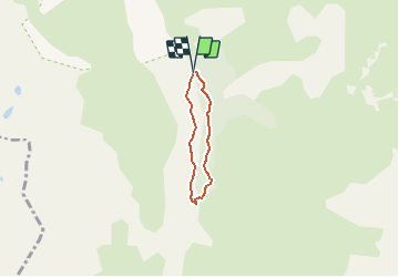
Trail Walking of 3.6 km to be discovered at Provence-Alpes-Côte d'Azur, Hautes-Alpes, La Chapelle-en-Valgaudémar. This trail is proposed by Dervalmarc.
Description
Attention aux nombreux patous ne pas s' approcher des brebis 'randonnée faire a l'automne en raison des couleurs de la végétation.
Positioning
Country:
France
Region :
Provence-Alpes-Côte d'Azur
Department/Province :
Hautes-Alpes
Municipality :
La Chapelle-en-Valgaudémar
Location:
Unknown
Start:(Dec)
Start:(UTM)
278597 ; 4964374 (32T) N.
Comments
Trails nearby
![Walking Walking](https://static1.geolcdn.com/sitytour/trail-icons/101.png)
Refuge de Chalance
Walking
Difficult
(1)
La Chapelle-en-Valgaudémar,
Provence-Alpes-Côte d'Azur,
Hautes-Alpes,
France
![](/images/other/stat-length.png)
7.5 km | 22 km-effort
5h 1min
![](https://static1.geolcdn.com/siteimages/upload/files/16400158638029165_repeat_loop_refresh_sync_direction_icon.png)
Yes
![Trail Walking La Chapelle-en-Valgaudémar - circuit de la cabane de l'aup .08-06-14 - Photo](https://media.geolcdn.com/t/375/260/ext.jpg?maxdim=2&url=https%3A%2F%2Fservices.sitytrail.com%2FGeolivesWS%2FDownloadMedia.ashx%3FTrailID%3D310408%26Media%3Dfix__20140608140628.jpg)
![Walking Walking](https://static1.geolcdn.com/sitytour/trail-icons/101.png)
circuit de la cabane de l'aup .08-06-14
Walking
Very easy
(1)
La Chapelle-en-Valgaudémar,
Provence-Alpes-Côte d'Azur,
Hautes-Alpes,
France
![](/images/other/stat-length.png)
8.8 km | 13.6 km-effort
2h 37min
![](https://static1.geolcdn.com/siteimages/upload/files/16400158638029165_repeat_loop_refresh_sync_direction_icon.png)
Yes
![Trail Walking La Chapelle-en-Valgaudémar - Tour du Vieux Chaillol 2/5 - Du Gîte Le Casset au Refuge de Vallonpierre - Photo](https://media.geolcdn.com/t/375/260/ext.jpg?maxdim=2&url=https%3A%2F%2Fservices.sitytrail.com%2FGeolivesWS%2FDownloadMedia.ashx%3FTrailID%3D110181%26Media%3D5395_2.jpg)
![Walking Walking](https://static1.geolcdn.com/sitytour/trail-icons/101.png)
Tour du Vieux Chaillol 2/5 - Du Gîte Le Casset au Refuge de Vallonpierre
Walking
Medium
(1)
La Chapelle-en-Valgaudémar,
Provence-Alpes-Côte d'Azur,
Hautes-Alpes,
France
![](/images/other/stat-length.png)
11.8 km | 24 km-effort
4h 30min
![](https://static1.geolcdn.com/siteimages/upload/files/16400158638029165_repeat_loop_refresh_sync_direction_icon.png)
No
![Trail Walking Villar-Loubière - Pic Turbat - Photo](https://media.geolcdn.com/t/375/260/d62b8d76-41e7-46f4-8b33-5d2b5ae47cbd.jpg&format=jpg&maxdim=2)
![Walking Walking](https://static1.geolcdn.com/sitytour/trail-icons/101.png)
Pic Turbat
Walking
Very difficult
Villar-Loubière,
Provence-Alpes-Côte d'Azur,
Hautes-Alpes,
France
![](/images/other/stat-length.png)
19.8 km | 46 km-effort
10h 26min
![](https://static1.geolcdn.com/siteimages/upload/files/16400158638029165_repeat_loop_refresh_sync_direction_icon.png)
Yes
![Trail Walking La Chapelle-en-Valgaudémar - Lacs de Pétarel-Col de la Béranne - Photo](https://media.geolcdn.com/t/375/260/5e28ea7d-88f9-46a3-ba95-03bb6ef09059.jpg&format=jpg&maxdim=2)
![Walking Walking](https://static1.geolcdn.com/sitytour/trail-icons/101.png)
Lacs de Pétarel-Col de la Béranne
Walking
Medium
La Chapelle-en-Valgaudémar,
Provence-Alpes-Côte d'Azur,
Hautes-Alpes,
France
![](/images/other/stat-length.png)
11.1 km | 23 km-effort
7h 0min
![](https://static1.geolcdn.com/siteimages/upload/files/16400158638029165_repeat_loop_refresh_sync_direction_icon.png)
Yes
![Walking Walking](https://static1.geolcdn.com/sitytour/trail-icons/101.png)
Pas de l'Olan
Walking
Very difficult
La Chapelle-en-Valgaudémar,
Provence-Alpes-Côte d'Azur,
Hautes-Alpes,
France
![](/images/other/stat-length.png)
12.6 km | 34 km-effort
7h 37min
![](https://static1.geolcdn.com/siteimages/upload/files/16400158638029165_repeat_loop_refresh_sync_direction_icon.png)
Yes
![Trail Walking La Chapelle-en-Valgaudémar - Valgaudemar - La Chapelle (les Portes) forêt - 4.3km 285m 1h35 - 2018 07 05 - public - Photo](https://media.geolcdn.com/t/375/260/ext.jpg?maxdim=2&url=https%3A%2F%2Fservices.sitytrail.com%2FGeolivesWS%2FDownloadMedia.ashx%3FTrailID%3D999071%26Media%3Dfix__20180705073135.jpg)
![Walking Walking](https://static1.geolcdn.com/sitytour/trail-icons/101.png)
Valgaudemar - La Chapelle (les Portes) forêt - 4.3km 285m 1h35 - 2018 07 05 -...
Walking
Easy
La Chapelle-en-Valgaudémar,
Provence-Alpes-Côte d'Azur,
Hautes-Alpes,
France
![](/images/other/stat-length.png)
4.3 km | 8.1 km-effort
1h 40min
![](https://static1.geolcdn.com/siteimages/upload/files/16400158638029165_repeat_loop_refresh_sync_direction_icon.png)
Yes
![Trail Walking La Chapelle-en-Valgaudémar - Valgaudemar - La Chapelle Vallon de la Navette - 10.9km 420m 3h25 - 2018 06 30 - public - Photo](https://media.geolcdn.com/t/375/260/ext.jpg?maxdim=2&url=https%3A%2F%2Fservices.sitytrail.com%2FGeolivesWS%2FDownloadMedia.ashx%3FTrailID%3D998812%26Media%3Dfix__20180630163125.jpg)
![Walking Walking](https://static1.geolcdn.com/sitytour/trail-icons/101.png)
Valgaudemar - La Chapelle Vallon de la Navette - 10.9km 420m 3h25 - 2018 06 3...
Walking
Medium
La Chapelle-en-Valgaudémar,
Provence-Alpes-Côte d'Azur,
Hautes-Alpes,
France
![](/images/other/stat-length.png)
10.9 km | 16.4 km-effort
4h 30min
![](https://static1.geolcdn.com/siteimages/upload/files/16400158638029165_repeat_loop_refresh_sync_direction_icon.png)
Yes
![Trail Walking La Chapelle-en-Valgaudémar - Valgaudemar - La Chapelle Vallée de la Séveraisse Refuge du Clot - 15.9km 450m 4h35 - 2018 07 01 - public - Photo](https://media.geolcdn.com/t/375/260/ext.jpg?maxdim=2&url=https%3A%2F%2Fservices.sitytrail.com%2FGeolivesWS%2FDownloadMedia.ashx%3FTrailID%3D998805%26Media%3Dfix__20180701095057.jpg)
![Walking Walking](https://static1.geolcdn.com/sitytour/trail-icons/101.png)
Valgaudemar - La Chapelle Vallée de la Séveraisse Refuge du Clot - 15.9km 450...
Walking
Medium
La Chapelle-en-Valgaudémar,
Provence-Alpes-Côte d'Azur,
Hautes-Alpes,
France
![](/images/other/stat-length.png)
15.9 km | 22 km-effort
5h 55min
![](https://static1.geolcdn.com/siteimages/upload/files/16400158638029165_repeat_loop_refresh_sync_direction_icon.png)
Yes