


White Rock 1

deka
User
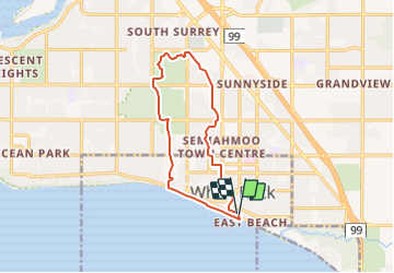

Length
11.5 km

Max alt
135 m

Uphill gradient
225 m
Km-Effort
14.5 km

Min alt
0 m

Downhill gradient
220 m
Boucle
Yes
Creation date :
2017-05-20 00:00:00.0
Updated on :
2017-05-20 00:00:00.0
3h07
Difficulty : Easy

FREE GPS app for hiking
 SityTrail
IGN / Geographical institutes
SityTrail World
The world is yours!
About
Trail Walking of 11.5 km to be discovered at British Columbia, Unknown, White Rock. This trail is proposed by deka.
Description
promenade le long de la plage, traversée des principaux parcs de la ville (Jonhson Park, Centenial Parc,Sunyside Acres Urban Forest et retour par le Semiahmoo Trail.
Positioning
Country:
Canada
Region :
British Columbia
Department/Province :
Unknown
Municipality :
White Rock
Location:
Unknown
Start:(Dec)
Start:(UTM)
514940 ; 5429599 (10U) N.
Comments
Trails nearby