Trail Walking Vieille-Toulouse - Boucle de Bécane - Photo
 iro
iro

User

© OpenStreetMap contributors
Length
Length
3.2 km
Max alt
Max alt
265 m
Uphill gradient
Uphill gradient
114 m
Km-Effort
Km-Effort  
4.7 km
Min alt
Min alt
195 m
Downhill gradient
Downhill gradient
114 m
Boucle
Boucle
Yes
Creation date :
2017-06-22 00:00:00.0
Updated on :
2017-06-22 00:00:00.0

(0 Reviews)

Walking
Walking
2h00
Difficulty : Difficult

Scan this QR Code to open this trail in the SityTrail application

FREE GPS app for hiking

Logo SityTrail SityTrail

IGN / Geographical institutes

Download SityTrail from the App Store Download SityTrail from Google Play

Logo SityTrail SityTrail World

The world is yours!

Download SityTrail from the App Store Download SityTrail from Google Play Download SityTrail on Huawei AppGallery

About

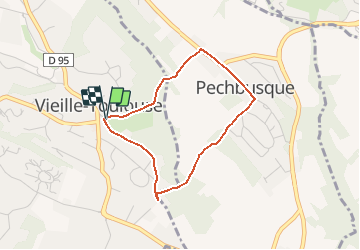
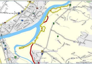
Trail Walking of 3.2 km to be discovered at Occitania, Haute-Garonne, Vieille-Toulouse. This trail is proposed by iro.

Description

Circuit proposé par le SICOVAL (Communauté d’Agglomération Sud-Est Toulousain)
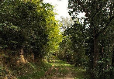
Reliant le village de Vieille-Toulouse à celui de Pechbusque, par le chemin de Saint Jacques de Compostelle, cette balade emmène le randonneur au cœur d’espaces boisés et ombragés, traversés par le ruisseau de Bécane. L’église de Pechbusque, halte des pèlerins, séduira les curieux par ses vitraux et son mobilier.
Réservée aux randonneurs pédestres et VTT (Fortement déconseillée par temps humide).

Elevation profile

Points of interest

Point of interest Pechbusque - Château de Planet - Photo
iro
PECHBUSQUE 
Point of interest Pechbusque - Eglise Saint-Jacques - Photo
iro
Point of interest Vieille-Toulouse - Tourner à gauche - Photo
iro
VIEILLE-TOULOUSE 
Point of interest Pechbusque - Poursuivre tout droit - Photo
iro
Point of interest Pechbusque - Point de vue - Photo
iro
PECHBUSQUE 
Point of interest Vieille-Toulouse - Point de vue - Photo
iro
VIEILLE-TOULOUSE 
Point of interest Vieille-Toulouse - Ancienne ferme de Borde Haute - Photo
iro

Positioning

Country:
France
Region :
Occitania
Department/Province :
Haute-Garonne
Municipality :
Vieille-Toulouse
Location:
Unknown
Start:(UTM)
374437 ; 4820431 (31T) N.

Trails nearby

Trail Mountain bike Pins-Justaret - De Pins Justaret à Clermont Le Fort - Photo
Mountain bike
tracegps

Mountain bike

Medium
(1)
Pins-Justaret, Occitania, Haute-Garonne, France
30 km | 35 km-effort
2h 30min
Yes
Trail Mountain bike Aureville - Aureville à Goyrans - Photo
Mountain bike
tracegps

Mountain bike

Medium
(1)
Aureville, Occitania, Haute-Garonne, France
14.9 km | 19.4 km-effort
1h 0min
Yes
Trail Walking Aureville - Aureville à Goyrans - Photo
Walking
tracegps

Walking

Medium
(1)
Aureville, Occitania, Haute-Garonne, France
14.9 km | 19.4 km-effort
3h 0min
Yes
Trail Walking Pinsaguel - PINSAGUEL : sentier de la Confluence (24.08.2023) - Photo
Walking
chrisgps

Walking

Very easy
Pinsaguel, Occitania, Haute-Garonne, France
3.8 km | 4.4 km-effort
1h 15min
Yes
Trail Walking Castanet-Tolosan - casranzt fait - Photo
Walking
pidjam

Walking

Very easy
(1)
Castanet-Tolosan, Occitania, Haute-Garonne, France
10.5 km | 12.6 km-effort
2h 26min
Yes
Trail Walking Lacroix-Falgarde - Promenade dominicale autour de Lacroix Falgarde - Photo
Walking
tracegps

Walking

Easy
Lacroix-Falgarde, Occitania, Haute-Garonne, France
8.6 km | 9.8 km-effort
2h 15min
Yes
Trail Walking Castanet-Tolosan - Boucle de Savignol  -  Castanet-Tolosan - Photo
Walking
tracegps

Walking

Medium
Castanet-Tolosan, Occitania, Haute-Garonne, France
10 km | 12.2 km-effort
2h 30min
Yes
Trail Walking Lacroix-Falgarde - Lacroix Falgarde - Goyrans - Photo
Walking
tracegps

Walking

Medium
Lacroix-Falgarde, Occitania, Haute-Garonne, France
8 km | 10 km-effort
2h 0min
Yes
Trail Walking Lacroix-Falgarde - Ariège Garonne variante - Lacroix Falgarde - Photo
Walking
tracegps

Walking

Easy
Lacroix-Falgarde, Occitania, Haute-Garonne, France
8.3 km | 9.6 km-effort
2h 30min
Yes


Close
My subscriptions