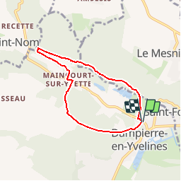
![](/images/other/stat-length.png)
![Trail Walking Dampierre-en-Yvelines - _La Genèse - Photo](https://media.geolcdn.com/t/1900/400/ext.pjpeg?maxdim=2&url=https%3A%2F%2Fservices.sitytrail.com%2FGeolivesWS%2FDownloadMedia.ashx%3FTrailID%3D746353%26Media%3D852eb799-755d-4473-ad2a-667c4a68a14c.jpg)
_La Genèse
Parc naturel régional de la Haute Vallée de Chevreuse
Randonnées du Parc naturel régional de la Haute Vallée de Chevreuse GUIDE+
![Length](/images/other/stat-length.png)
![Max alt](https://static1.geolcdn.com/siteimages/upload/files/1508320355ic_sort_altitude_max_24dp.png)
![Uphill gradient](https://static1.geolcdn.com/siteimages/upload/files/1508320355ic_sort_den_pos_24dp.png)
![Km-Effort](/images/other/stat-length.png)
![Min alt](https://static1.geolcdn.com/siteimages/upload/files/1508320355ic_sort_altitude_min_24dp.png)
![Downhill gradient](https://static1.geolcdn.com/siteimages/upload/files/1508320355ic_sort_den_neg_24dp.png)
![Boucle](https://static1.geolcdn.com/siteimages/upload/files/16400158638029165_repeat_loop_refresh_sync_direction_icon.png)
![Walking](https://static1.geolcdn.com/sitytour/trail-icons/101.png)
1h30
Difficulty : Easy
![Scan this QR Code to open this trail in the SityTrail application](https://capi.geolives.com/qq0zvz2zws4bq2lad0pu/sitytour/trails/746353/qr.png?size=200)
FREE GPS app for hiking
About
Trail Walking of 5.7 km to be discovered at Ile-de-France, Yvelines, Dampierre-en-Yvelines. This trail is proposed by Parc naturel régional de la Haute Vallée de Chevreuse.
Description
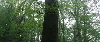
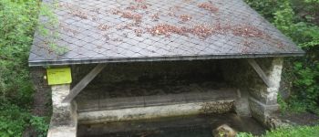
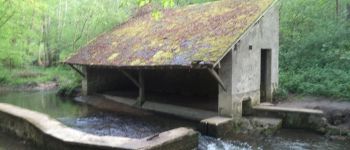
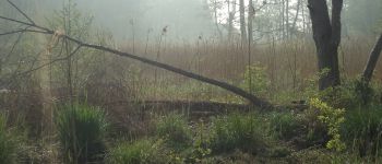
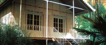
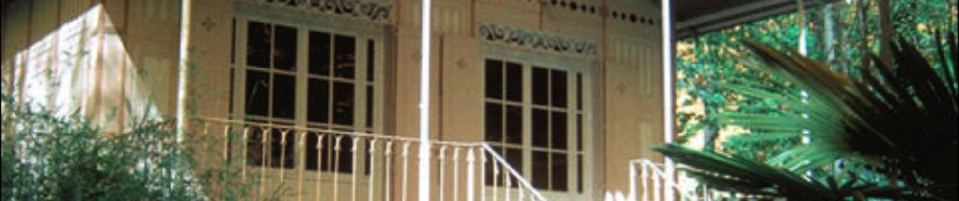
Un château prestigieux, un vallon enchanteur, une roselière secrète, l'un des plus anciens moulins de France, une mairie-église, une maison de fer... voila le programme de cette balade au fil du site qui est à l'origine du Parc naturel régional de la Haute Vallée de Chevreuse.
Points of interest
Positioning
Comments
Trails nearby
![Trail Walking Dampierre-en-Yvelines - _Villages par mont et par vaux - Photo](https://media.geolcdn.com/t/375/260/ext.jpg?maxdim=2&url=https%3A%2F%2Fservices.sitytrail.com%2FGeolivesWS%2FDownloadMedia.ashx%3FTrailID%3D172084%26Media%3D1ba0ac7a-e5bc-4661-87da-e3aa68337b06.jpg)
![Walking Walking](https://static1.geolcdn.com/sitytour/trail-icons/101.png)
Walking
![](/images/other/stat-length.png)
![](https://static1.geolcdn.com/siteimages/upload/files/16400158638029165_repeat_loop_refresh_sync_direction_icon.png)
![Trail Walking Cernay-la-Ville - _Senlisse dans un écrin de verdure - Photo](https://media.geolcdn.com/t/375/260/ext.jpg?maxdim=2&url=https%3A%2F%2Fservices.sitytrail.com%2FGeolivesWS%2FDownloadMedia.ashx%3FTrailID%3D172082%26Media%3D58eba867-baea-4143-80e9-e47f03036c03.jpg)
![Walking Walking](https://static1.geolcdn.com/sitytour/trail-icons/101.png)
Walking
![](/images/other/stat-length.png)
![](https://static1.geolcdn.com/siteimages/upload/files/16400158638029165_repeat_loop_refresh_sync_direction_icon.png)
![Trail Walking Saint-Forget - _Saint-Forget, fief de Cyrano de Bergerac - Photo](https://media.geolcdn.com/t/375/260/ext.jpg?maxdim=2&url=https%3A%2F%2Fservices.sitytrail.com%2FGeolivesWS%2FDownloadMedia.ashx%3FTrailID%3D172086%26Media%3D7b590dd2-7d00-4099-a55f-664d59f11356.jpg)
![Walking Walking](https://static1.geolcdn.com/sitytour/trail-icons/101.png)
Walking
![](/images/other/stat-length.png)
![](https://static1.geolcdn.com/siteimages/upload/files/16400158638029165_repeat_loop_refresh_sync_direction_icon.png)
![Trail Walking Cernay-la-Ville - _Moulins des vaux de Cernay - Photo](https://media.geolcdn.com/t/375/260/ext.jpg?maxdim=2&url=https%3A%2F%2Fservices.sitytrail.com%2FGeolivesWS%2FDownloadMedia.ashx%3FTrailID%3D792341%26Media%3D9a8eb0df-2390-435a-866e-b0dd9677df49.JPG)
![Walking Walking](https://static1.geolcdn.com/sitytour/trail-icons/101.png)
Walking
![](/images/other/stat-length.png)
![](https://static1.geolcdn.com/siteimages/upload/files/16400158638029165_repeat_loop_refresh_sync_direction_icon.png)
![Trail Walking Chevreuse - _La balade de tous les plaisirs - Photo](https://media.geolcdn.com/t/375/260/ext.jpg?maxdim=2&url=https%3A%2F%2Fservices.sitytrail.com%2FGeolivesWS%2FDownloadMedia.ashx%3FTrailID%3D754966%26Media%3D761e5f27-0704-4761-a8b3-7fd3e291dd40.jpg)
![Walking Walking](https://static1.geolcdn.com/sitytour/trail-icons/101.png)
Walking
![](/images/other/stat-length.png)
![](https://static1.geolcdn.com/siteimages/upload/files/16400158638029165_repeat_loop_refresh_sync_direction_icon.png)
![Trail Walking Chevreuse - _Sur les pas de Racine (première partie) - Photo](https://media.geolcdn.com/t/375/260/ext.jpg?maxdim=2&url=https%3A%2F%2Fservices.sitytrail.com%2FGeolivesWS%2FDownloadMedia.ashx%3FTrailID%3D745166%26Media%3Dd5380f95-aa62-43a2-a37c-8510f53d593d.JPG)
![Walking Walking](https://static1.geolcdn.com/sitytour/trail-icons/101.png)
Walking
![](/images/other/stat-length.png)
![](https://static1.geolcdn.com/siteimages/upload/files/16400158638029165_repeat_loop_refresh_sync_direction_icon.png)
![Trail Walking Lévis-Saint-Nom - _Le Vallon du Pommeret - Photo](https://media.geolcdn.com/t/375/260/ext.jpg?maxdim=2&url=https%3A%2F%2Fservices.sitytrail.com%2FGeolivesWS%2FDownloadMedia.ashx%3FTrailID%3D172087%26Media%3D296168f6-bac5-406d-9015-aae13e393b5e.jpg)
![Walking Walking](https://static1.geolcdn.com/sitytour/trail-icons/101.png)
Walking
![](/images/other/stat-length.png)
![](https://static1.geolcdn.com/siteimages/upload/files/16400158638029165_repeat_loop_refresh_sync_direction_icon.png)
![Trail Walking Choisel - _Si Choisel m'était conté - Photo](https://media.geolcdn.com/t/375/260/ext.jpg?maxdim=2&url=https%3A%2F%2Fservices.sitytrail.com%2FGeolivesWS%2FDownloadMedia.ashx%3FTrailID%3D172083%26Media%3De60082f0-edf4-45f4-997a-35e9c7c799de.jpg)
![Walking Walking](https://static1.geolcdn.com/sitytour/trail-icons/101.png)
Walking
![](/images/other/stat-length.png)
![](https://static1.geolcdn.com/siteimages/upload/files/16400158638029165_repeat_loop_refresh_sync_direction_icon.png)
![Trail Walking Senlisse - _Sentier découverte des maréchaux - Photo](https://media.geolcdn.com/t/375/260/ext.jpg?maxdim=2&url=https%3A%2F%2Fservices.sitytrail.com%2FGeolivesWS%2FDownloadMedia.ashx%3FTrailID%3D792820%26Media%3D3d8a65e5-a46f-42a3-8cf9-3bcb3c260e3a.png)
![Walking Walking](https://static1.geolcdn.com/sitytour/trail-icons/101.png)
Walking
![](/images/other/stat-length.png)
![](https://static1.geolcdn.com/siteimages/upload/files/16400158638029165_repeat_loop_refresh_sync_direction_icon.png)
vaut le détour 👍
Très agréable ballade a travers les bois, les marais et de jolis villages. A faire et à refaire au fil des saisons
Vaut vraiment le coup !!!
Une très belle ballade entre forêt et marais . Un vrai régal .
Un bien jolie promenade au milieu de la forêt et des marais
Aucun point dangereux. Peu inondable et bien entretenu. Envisageable pour des enfants à partir de 8-9 ans. Un réseau de passerelles de bois sur un marais à la moitié du parcours. Vue imprenable sur le château à la fin. Seul défaut: du monde sur les 1ers 60% du parcours, tranquille ensuite. 5 étoiles amplement méritées.
Chemin bien entretenu et relativement peu inondable. Aucun point dangereux. A la moitié du parcours: un réseau de passerelles de bois sur un marais. La ballade termine sur une vue en hauteur du château de Dampierre. Envisageable pour des enfants à partir de 8-9 ans. Seul point négatif: le monde sur les 60 premiers % du parcours. 5 étoiles amplement méritées.
Jolie promenade. prévoir un pantalon (orties fréquentes). Poussette fortement déconseillée (chemins escarpes