Trail Running Écuillé - 2016 Trail nocturne d'écuillé - Photo

2016 Trail nocturne d'écuillé

© OpenStreetMap contributors
Length
Length
18.2 km
Max alt
Max alt
78 m
Uphill gradient
Uphill gradient
205 m
Km-Effort
Km-Effort  
21 km
Min alt
Min alt
26 m
Downhill gradient
Downhill gradient
206 m
Boucle
Boucle
Yes
Creation date :
2017-05-03 00:00:00.0
Updated on :
2017-05-03 00:00:00.0

(0 Reviews)

Running
Running
2h03
Difficulty : Medium

Scan this QR Code to open this trail in the SityTrail application

FREE GPS app for hiking

Logo SityTrail SityTrail

IGN / Geographical institutes

Download SityTrail from the App Store Download SityTrail from Google Play

Logo SityTrail SityTrail World

The world is yours!

Download SityTrail from the App Store Download SityTrail from Google Play Download SityTrail on Huawei AppGallery

About

Trail Running of 18.2 km to be discovered at Pays de la Loire, Maine-et-Loire, Écuillé. This trail is proposed by Remi44184532.

Description

2016 12 10 nocturne Ecuillé

Elevation profile

Positioning

Country:
France
Region :
Pays de la Loire
Department/Province :
Maine-et-Loire
Municipality :
Écuillé
Location:
Unknown
Start:(UTM)
684593 ; 5274870 (30T) N.

Trails nearby

Trail Walking Briollay - Au fil de la Sarthe - Briollay - Photo
Walking
tracegps

Walking

Difficult
(3)
Briollay, Pays de la Loire, Maine-et-Loire, France
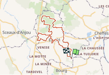
18.1 km | 19.3 km-effort
4h 15min
Yes
Trail On foot Soulaire-et-Bourg - randogps49-204 - Photo
On foot
MarcBoscher

On foot

Easy
(2)
Soulaire-et-Bourg, Pays de la Loire, Maine-et-Loire, France
12.4 km | 13.9 km-effort
3h 10min
Yes
Trail Walking Briollay - le Loir  - Photo
Walking
piquet

Walking

Very easy
Briollay, Pays de la Loire, Maine-et-Loire, France
9.3 km | 10.5 km-effort
2h 43min
No
Trail Walking Briollay - La Sarthe-11-Briollay - Angers - Photo
Walking
SERUS

Walking

Easy
Briollay, Pays de la Loire, Maine-et-Loire, France
13.8 km | 15.4 km-effort
3h 27min
No
Trail Walking Cheffes - Cheffes - Photo
Walking
Polenade

Walking

Medium
Cheffes, Pays de la Loire, Maine-et-Loire, France
8.4 km | 9.4 km-effort
1h 49min
Yes
Trail Walking Feneu - feneu - Photo
Walking
laoj

Walking

Difficult
Feneu, Pays de la Loire, Maine-et-Loire, France
11.4 km | 12.6 km-effort
2h 47min
Yes
Trail Walking Sceaux-d'Anjou - track - Photo
Walking
bubuserge

Walking

Difficult
Sceaux-d'Anjou, Pays de la Loire, Maine-et-Loire, France
15.2 km | 16.6 km-effort
3h 41min
Yes
Trail Walking Cheffes - randogps49-263 - Photo
Walking
bubuserge

Walking

Medium
Cheffes, Pays de la Loire, Maine-et-Loire, France
9.4 km | 10.5 km-effort
2h 19min
Yes
Trail Walking Feneu - Feneu avec pierre  - Photo
Walking
bubuserge

Walking

Difficult
Feneu, Pays de la Loire, Maine-et-Loire, France
16.8 km | 0 m-effort
3h 39min
Yes


Close
My subscriptions