![](/images/other/stat-length.png)
![Trail Walking Soulosse-sous-Saint-Élophe - Saint Elophe et Brancourt - Photo](https://media.geolcdn.com/t/1900/400/ext.pjpeg?maxdim=2&url=https%3A%2F%2Fservices.sitytrail.com%2FGeolivesWS%2FDownloadMedia.ashx%3FTrailID%3D745041%26Media%3D20170503103402.jpg)
Saint Elophe et Brancourt
Samuel88300
User
![Length](/images/other/stat-length.png)
Length
4.1 km
![Max alt](https://static1.geolcdn.com/siteimages/upload/files/1508320355ic_sort_altitude_max_24dp.png)
Max alt
327 m
![Uphill gradient](https://static1.geolcdn.com/siteimages/upload/files/1508320355ic_sort_den_pos_24dp.png)
Uphill gradient
66 m
![Km-Effort](/images/other/stat-length.png)
Km-Effort
5 km
![Min alt](https://static1.geolcdn.com/siteimages/upload/files/1508320355ic_sort_altitude_min_24dp.png)
Min alt
278 m
![Downhill gradient](https://static1.geolcdn.com/siteimages/upload/files/1508320355ic_sort_den_neg_24dp.png)
Downhill gradient
73 m
![Boucle](https://static1.geolcdn.com/siteimages/upload/files/16400158638029165_repeat_loop_refresh_sync_direction_icon.png)
Boucle
Yes
Creation date :
2017-05-03 00:00:00.0
Updated on :
2017-05-03 00:00:00.0
![Walking](https://static1.geolcdn.com/sitytour/trail-icons/101.png)
1h03
Difficulty : Very easy
![Scan this QR Code to open this trail in the SityTrail application](https://capi.geolives.com/qq0zvz2zws4bq2lad0pu/sitytour/trails/745041/qr.png?size=200)
FREE GPS app for hiking
About
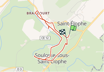
Trail Walking of 4.1 km to be discovered at Grand Est, Vosges, Soulosse-sous-Saint-Élophe. This trail is proposed by Samuel88300.
Description
Courte randonnée d'une heure environ au départ de la mairie de Saint-Elophe, avec un petit détour pour voir La Chapelle Saint-Epeothe.
Positioning
Country:
France
Region :
Grand Est
Department/Province :
Vosges
Municipality :
Soulosse-sous-Saint-Élophe
Location:
Unknown
Start:(Dec)
Start:(UTM)
702729 ; 5365394 (31U) N.
Comments
Trails nearby
![Trail On foot Domrémy-la-Pucelle - Sentier de Jeanne - Photo](https://media.geolcdn.com/t/375/260/a2622b9d-5872-46fc-903e-cc89f3a94891.jpeg&format=jpg&maxdim=2)
![On foot On foot](https://static1.geolcdn.com/sitytour/trail-icons/100.png)
Sentier de Jeanne
On foot
Easy
Domrémy-la-Pucelle,
Grand Est,
Vosges,
France
![](/images/other/stat-length.png)
13.3 km | 16.4 km-effort
3h 43min
![](https://static1.geolcdn.com/siteimages/upload/files/16400158638029165_repeat_loop_refresh_sync_direction_icon.png)
Yes
![Trail On foot Maxey-sur-Meuse - Sentier de Jeanne - Variante Maxey-Brixey - Photo](https://media.geolcdn.com/t/375/260/88d42f23-632c-42ae-a0de-47c4afa06d41.jpeg&format=jpg&maxdim=2)
![On foot On foot](https://static1.geolcdn.com/sitytour/trail-icons/100.png)
Sentier de Jeanne - Variante Maxey-Brixey
On foot
Easy
Maxey-sur-Meuse,
Grand Est,
Vosges,
France
![](/images/other/stat-length.png)
7.8 km | 9.8 km-effort
2h 13min
![](https://static1.geolcdn.com/siteimages/upload/files/16400158638029165_repeat_loop_refresh_sync_direction_icon.png)
Yes
![Trail On foot Domrémy-la-Pucelle - DOMRÉMY LA PUCELLE - Photo](https://media.geolcdn.com/t/375/260/ext.jpg?maxdim=2&url=https%3A%2F%2Fstatic1.geolcdn.com%2Fsiteimages%2Fupload%2Ffiles%2F1545311037marcheuse_200dpi.jpg)
![On foot On foot](https://static1.geolcdn.com/sitytour/trail-icons/100.png)
DOMRÉMY LA PUCELLE
On foot
Easy
(1)
Domrémy-la-Pucelle,
Grand Est,
Vosges,
France
![](/images/other/stat-length.png)
10.9 km | 13.7 km-effort
3h 6min
![](https://static1.geolcdn.com/siteimages/upload/files/16400158638029165_repeat_loop_refresh_sync_direction_icon.png)
Yes
![Trail Horseback riding Autigny-la-Tour - Autigny la tour marche gourmande 25 aout 2024 anime ta campagne - Photo](https://media.geolcdn.com/t/375/260/ebf77082-b874-4fdf-9aaf-2231727ec778.jpg&format=jpg&maxdim=2)
![Horseback riding Horseback riding](https://static1.geolcdn.com/sitytour/trail-icons/301.png)
Autigny la tour marche gourmande 25 aout 2024 anime ta campagne
Horseback riding
Difficult
Autigny-la-Tour,
Grand Est,
Vosges,
France
![](/images/other/stat-length.png)
28 km | 34 km-effort
4h 24min
![](https://static1.geolcdn.com/siteimages/upload/files/16400158638029165_repeat_loop_refresh_sync_direction_icon.png)
Yes
![Trail Horseback riding Autigny-la-Tour - Anime ta campagne marche gourmande à Autigny la tour 25 aout 2024 - Photo](https://media.geolcdn.com/t/375/260/4f94057e-4933-4189-a937-bdf9405ab289.jpg&format=jpg&maxdim=2)
![Horseback riding Horseback riding](https://static1.geolcdn.com/sitytour/trail-icons/301.png)
Anime ta campagne marche gourmande à Autigny la tour 25 aout 2024
Horseback riding
Difficult
Autigny-la-Tour,
Grand Est,
Vosges,
France
![](/images/other/stat-length.png)
28 km | 34 km-effort
4h 24min
![](https://static1.geolcdn.com/siteimages/upload/files/16400158638029165_repeat_loop_refresh_sync_direction_icon.png)
Yes
![Trail Walking Coussey - de Coussey à Vouthon - Photo](https://media.geolcdn.com/t/375/260/f7d89dff-7688-4e62-915f-05487086b592.jpg&format=jpg&maxdim=2)
![Walking Walking](https://static1.geolcdn.com/sitytour/trail-icons/101.png)
de Coussey à Vouthon
Walking
Medium
Coussey,
Grand Est,
Vosges,
France
![](/images/other/stat-length.png)
11.3 km | 14.3 km-effort
2h 9min
![](https://static1.geolcdn.com/siteimages/upload/files/16400158638029165_repeat_loop_refresh_sync_direction_icon.png)
No
![Trail Road bike Domrémy-la-Pucelle - projet 3 Orléans - Photo](https://media.geolcdn.com/t/375/260/ext.jpg?maxdim=2&url=https%3A%2F%2Fstatic1.geolcdn.com%2Fsiteimages%2Fupload%2Ffiles%2F1524743154velo.jpg)
![Road bike Road bike](https://static1.geolcdn.com/sitytour/trail-icons/201.png)
projet 3 Orléans
Road bike
Medium
Domrémy-la-Pucelle,
Grand Est,
Vosges,
France
![](/images/other/stat-length.png)
356 km | 391 km-effort
23h 41min
![](https://static1.geolcdn.com/siteimages/upload/files/16400158638029165_repeat_loop_refresh_sync_direction_icon.png)
No
![Trail Walking Domrémy-la-Pucelle - domremy la pucelle - Photo](https://media.geolcdn.com/t/375/260/65dcf2a1-dc6c-467f-a0b9-365a2892f599.jpg&format=jpg&maxdim=2)
![Walking Walking](https://static1.geolcdn.com/sitytour/trail-icons/101.png)
domremy la pucelle
Walking
Easy
Domrémy-la-Pucelle,
Grand Est,
Vosges,
France
![](/images/other/stat-length.png)
4.6 km | 5.7 km-effort
2h 27min
![](https://static1.geolcdn.com/siteimages/upload/files/16400158638029165_repeat_loop_refresh_sync_direction_icon.png)
Yes
![Trail Walking Harchéchamp - harchechamp - Photo](https://media.geolcdn.com/t/375/260/ext.jpg?maxdim=2&url=https%3A%2F%2Fstatic1.geolcdn.com%2Fsiteimages%2Fupload%2Ffiles%2F1553511878bg_sport_marche.png)
![Walking Walking](https://static1.geolcdn.com/sitytour/trail-icons/101.png)
harchechamp
Walking
Easy
Harchéchamp,
Grand Est,
Vosges,
France
![](/images/other/stat-length.png)
12.7 km | 16.3 km-effort
3h 20min
![](https://static1.geolcdn.com/siteimages/upload/files/16400158638029165_repeat_loop_refresh_sync_direction_icon.png)
Yes