


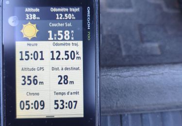
13 km | 20 km-effort


User


FREE GPS app for hiking
 SityTrail
IGN / Geographical institutes
SityTrail World
The world is yours!
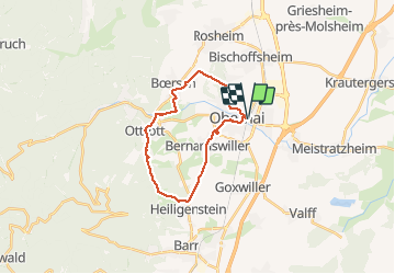
Trail Walking of 21 km to be discovered at Grand Est, Bas-Rhin, Obernai. This trail is proposed by VacheKiri67.
Faite le 30/04/2017 avec notre fils Théo de 12 ans. D'après "Passion Vosges - Autour du Mont Sainte-Odile" N°12 : Le Piémont du Mont Sainte-Odile. Durée indiquée pour le circuit : 5h30.


21 photos in total. Please click on a photo to see them all in the gallery.

Walking

Walking

Mountain bike

On foot

On foot

Mountain bike

Walking
Walking

Electric bike
Randonnée assez longue mais sans difficulté. Idéale au printemps pour se refaire les jambes.