Trail Walking La Chapelle-Saint-Sépulcre - La montagneuse - Photo
© OpenStreetMap contributors
Length
Length
10.5 km
Max alt
Max alt
142 m
Uphill gradient
Uphill gradient
136 m
Km-Effort
Km-Effort  
12.4 km
Min alt
Min alt
102 m
Downhill gradient
Downhill gradient
136 m
Boucle
Boucle
Yes
Creation date :
2019-05-03 09:14:50.398
Updated on :
2019-05-03 09:14:50.434

(0 Reviews)

Walking
Walking
2h30
Difficulty : Medium

Scan this QR Code to open this trail in the SityTrail application

FREE GPS app for hiking

Logo SityTrail SityTrail

IGN / Geographical institutes

Download SityTrail from the App Store Download SityTrail from Google Play

Logo SityTrail SityTrail World

The world is yours!

Download SityTrail from the App Store Download SityTrail from Google Play Download SityTrail on Huawei AppGallery

About

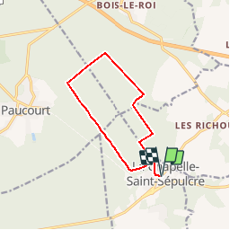
Trail Walking of 10.5 km to be discovered at Centre-Loire Valley, Loiret, La Chapelle-Saint-Sépulcre. This trail is proposed by Ordijamo45.

Description

Départ de l’église de La chapelle saint Sépulcre (45)
Parcourt de 10.5 km
partie de la route de la montagneuse en forêt de Montargis avec du dénivelé mais belle randonnée

Elevation profile

Positioning

Country:
France
Region :
Centre-Loire Valley
Department/Province :
Loiret
Municipality :
La Chapelle-Saint-Sépulcre
Location:
Unknown
Start:(UTM)
488444 ; 5318332 (31U) N.

Comments

Please log in to post a review or rate the element


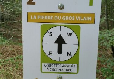
Nous voullions changer de la forêt de Fontainebleau. A recommencer... pas trop souvent ??


Trails nearby

Trail Walking Paucourt - Foret de Paucourt 1 - Photo
Walking
kudours

Walking

Medium
(1)
Paucourt, Centre-Loire Valley, Loiret, France
5.9 km | 6.9 km-effort
1h 30min
Yes
Trail Walking Paucourt - paucourt - Photo
Walking
Ordijamo45

Walking

Very easy
Paucourt, Centre-Loire Valley, Loiret, France
9 km | 9.9 km-effort
2h 7min
Yes
Trail Walking Paucourt - 2021-03-02_12h15m27_bxiv-PWv68M - Photo
Walking
Ordijamo45

Walking

Easy
Paucourt, Centre-Loire Valley, Loiret, France
12.7 km | 14.4 km-effort
3h 15min
Yes
Trail Walking Louzouer - les richoux - Photo
Walking
BlRoger

Walking

Very easy
Louzouer, Centre-Loire Valley, Loiret, France
37 km | 40 km-effort
3h 5min
No
Trail Walking Paucourt - de Paucourt à St sépulcre et retour  - Photo
Walking
BRASSENS

Walking

Easy
Paucourt, Centre-Loire Valley, Loiret, France
8.2 km | 9.4 km-effort
2h 11min
Yes
Trail Walking Paucourt - Paucourt 45 12km5 Arle - Photo
Walking
picouleau220345

Walking

Medium
Paucourt, Centre-Loire Valley, Loiret, France
38 km | 42 km-effort
3h 17min
No
Trail Walking Louzouer - Rando du menhir - Photo
Walking
Philippepauleau

Walking

Easy
Louzouer, Centre-Loire Valley, Loiret, France
16.8 km | 18.9 km-effort
3h 5min
Yes
Trail Walking Paucourt - Foret de Paucourt 2 - Photo
Walking
kudours

Walking

Medium
Paucourt, Centre-Loire Valley, Loiret, France
7.9 km | 9.1 km-effort
1h 59min
Yes
Trail Walking Saint-Germain-des-Prés - montargis 01 - Photo
Walking
ah45

Walking

Very easy
Saint-Germain-des-Prés, Centre-Loire Valley, Loiret, France
31 km | 34 km-effort
1h 33min
Yes


Close
My subscriptions