![](/images/other/stat-length.png)
![Trail Walking La Chapelle-d'Alagnon - Murat Bonnevie St Antoine 2017-04 - Photo](https://media.geolcdn.com/t/1900/400/ext.pjpeg?maxdim=2&url=https%3A%2F%2Fstatic1.geolcdn.com%2Fsiteimages%2Fupload%2Ffiles%2F1553511878bg_sport_marche.png)
Murat Bonnevie St Antoine 2017-04
zanogueb
User
![Length](/images/other/stat-length.png)
Length
13.6 km
![Max alt](https://static1.geolcdn.com/siteimages/upload/files/1508320355ic_sort_altitude_max_24dp.png)
Max alt
1179 m
![Uphill gradient](https://static1.geolcdn.com/siteimages/upload/files/1508320355ic_sort_den_pos_24dp.png)
Uphill gradient
398 m
![Km-Effort](/images/other/stat-length.png)
Km-Effort
18.9 km
![Min alt](https://static1.geolcdn.com/siteimages/upload/files/1508320355ic_sort_altitude_min_24dp.png)
Min alt
874 m
![Downhill gradient](https://static1.geolcdn.com/siteimages/upload/files/1508320355ic_sort_den_neg_24dp.png)
Downhill gradient
400 m
![Boucle](https://static1.geolcdn.com/siteimages/upload/files/16400158638029165_repeat_loop_refresh_sync_direction_icon.png)
Boucle
Yes
Creation date :
2017-04-30 00:00:00.0
Updated on :
2020-06-03 16:57:12.389
![Walking](https://static1.geolcdn.com/sitytour/trail-icons/101.png)
4h10
Difficulty : Medium
![Scan this QR Code to open this trail in the SityTrail application](https://capi.geolives.com/qq0zvz2zws4bq2lad0pu/sitytour/trails/742358/qr.png?size=200)
FREE GPS app for hiking
About
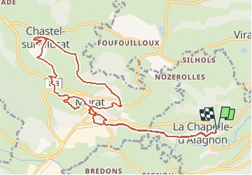
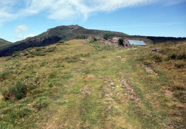
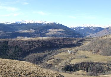
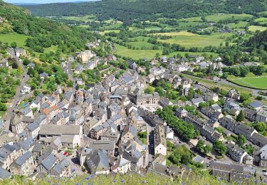
Trail Walking of 13.6 km to be discovered at Auvergne-Rhône-Alpes, Cantal, La Chapelle-d'Alagnon. This trail is proposed by zanogueb.
Description
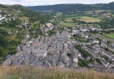
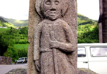
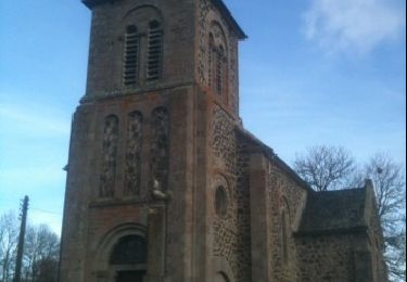
Départ de La Chapelle d'Alagnon puis centre ville de Murat pour faire le parcours passant par La Chapelle St Antoine et monter à La Vierge de La Bonnevie.
Positioning
Country:
France
Region :
Auvergne-Rhône-Alpes
Department/Province :
Cantal
Municipality :
La Chapelle-d'Alagnon
Location:
Unknown
Start:(Dec)
Start:(UTM)
492101 ; 4995014 (31T) N.
Comments
Trails nearby
![Trail Walking Murat - les estives et tourbière de Chastel sur Murat - Photo](https://media.geolcdn.com/t/375/260/177cc3c3-d770-480f-901b-cbeaabf71678.jpg&format=jpg&maxdim=2)
![Walking Walking](https://static1.geolcdn.com/sitytour/trail-icons/101.png)
les estives et tourbière de Chastel sur Murat
Walking
Easy
(1)
Murat,
Auvergne-Rhône-Alpes,
Cantal,
France
![](/images/other/stat-length.png)
7.7 km | 10.5 km-effort
2h 16min
![](https://static1.geolcdn.com/siteimages/upload/files/16400158638029165_repeat_loop_refresh_sync_direction_icon.png)
Yes
![Trail Walking Murat - Murat - La Bonnevie de Saint-Antoine - Photo](https://media.geolcdn.com/t/375/260/995e7d15-38bd-40a6-9dac-530bc92ad865.jpg&format=jpg&maxdim=2)
![Walking Walking](https://static1.geolcdn.com/sitytour/trail-icons/101.png)
Murat - La Bonnevie de Saint-Antoine
Walking
Easy
Murat,
Auvergne-Rhône-Alpes,
Cantal,
France
![](/images/other/stat-length.png)
8.7 km | 13.1 km-effort
3h 24min
![](https://static1.geolcdn.com/siteimages/upload/files/16400158638029165_repeat_loop_refresh_sync_direction_icon.png)
Yes
![Walking Walking](https://static1.geolcdn.com/sitytour/trail-icons/101.png)
GR400 Tour du Cantal
Walking
Difficult
Murat,
Auvergne-Rhône-Alpes,
Cantal,
France
![](/images/other/stat-length.png)
133 km | 217 km-effort
44h 36min
![](https://static1.geolcdn.com/siteimages/upload/files/16400158638029165_repeat_loop_refresh_sync_direction_icon.png)
Yes
![Trail Cycle Ussel - L'Usclade - Ussel - Photo](https://media.geolcdn.com/t/375/260/ext.jpg?maxdim=2&url=https%3A%2F%2Fservices.sitytrail.com%2FGeolivesWS%2FDownloadMedia.ashx%3FTrailID%3D317947%26Media%3D17380_6.jpg)
![Cycle Cycle](https://static1.geolcdn.com/sitytour/trail-icons/200.png)
L'Usclade - Ussel
Cycle
Difficult
Ussel,
Auvergne-Rhône-Alpes,
Cantal,
France
![](/images/other/stat-length.png)
72 km | 87 km-effort
3h 0min
![](https://static1.geolcdn.com/siteimages/upload/files/16400158638029165_repeat_loop_refresh_sync_direction_icon.png)
Yes
![Trail Walking Murat - La Via Arverna (Murat - Saint Jacques des Blats) - Photo](https://media.geolcdn.com/t/375/260/ext.jpg?maxdim=2&url=https%3A%2F%2Fservices.sitytrail.com%2FGeolivesWS%2FDownloadMedia.ashx%3FTrailID%3D173009%26Media%3D14510_6.jpg)
![Walking Walking](https://static1.geolcdn.com/sitytour/trail-icons/101.png)
La Via Arverna (Murat - Saint Jacques des Blats)
Walking
Difficult
Murat,
Auvergne-Rhône-Alpes,
Cantal,
France
![](/images/other/stat-length.png)
27 km | 41 km-effort
8h 0min
![](https://static1.geolcdn.com/siteimages/upload/files/16400158638029165_repeat_loop_refresh_sync_direction_icon.png)
No
![Trail Walking Murat - Murat - Photo](https://media.geolcdn.com/t/375/260/ext.jpg?maxdim=2&url=https%3A%2F%2Fservices.sitytrail.com%2FGeolivesWS%2FDownloadMedia.ashx%3FTrailID%3D167890%26Media%3D20121230152910.jpg)
![Walking Walking](https://static1.geolcdn.com/sitytour/trail-icons/101.png)
Murat
Walking
Very easy
Murat,
Auvergne-Rhône-Alpes,
Cantal,
France
![](/images/other/stat-length.png)
5.5 km | 8 km-effort
1h 13min
![](https://static1.geolcdn.com/siteimages/upload/files/16400158638029165_repeat_loop_refresh_sync_direction_icon.png)
Yes
![Trail Walking Murat - De Murat à St. Jacques des Blats - Photo](https://media.geolcdn.com/t/375/260/ext.jpg?maxdim=2&url=https%3A%2F%2Fservices.sitytrail.com%2FGeolivesWS%2FDownloadMedia.ashx%3FTrailID%3D103630%26Media%3D6024_5.jpg)
![Walking Walking](https://static1.geolcdn.com/sitytour/trail-icons/101.png)
De Murat à St. Jacques des Blats
Walking
Difficult
Murat,
Auvergne-Rhône-Alpes,
Cantal,
France
![](/images/other/stat-length.png)
25 km | 39 km-effort
7h 0min
![](https://static1.geolcdn.com/siteimages/upload/files/16400158638029165_repeat_loop_refresh_sync_direction_icon.png)
No
![Trail Walking Murat - La bonnevie de Saint Antoine - Photo](https://media.geolcdn.com/t/375/260/ext.jpg?maxdim=2&url=https%3A%2F%2Fservices.sitytrail.com%2FGeolivesWS%2FDownloadMedia.ashx%3FTrailID%3D102073%26Media%3D2432_5.jpg)
![Walking Walking](https://static1.geolcdn.com/sitytour/trail-icons/101.png)
La bonnevie de Saint Antoine
Walking
Easy
Murat,
Auvergne-Rhône-Alpes,
Cantal,
France
![](/images/other/stat-length.png)
7.7 km | 11.3 km-effort
2h 0min
![](https://static1.geolcdn.com/siteimages/upload/files/16400158638029165_repeat_loop_refresh_sync_direction_icon.png)
Yes
![Trail Walking Murat - Etape 0 - Photo](https://media.geolcdn.com/t/375/260/ba0c2784-8d70-4901-be9b-6a6cb4f0534d.jpg&format=jpg&maxdim=2)
![Walking Walking](https://static1.geolcdn.com/sitytour/trail-icons/101.png)
Etape 0
Walking
Easy
Murat,
Auvergne-Rhône-Alpes,
Cantal,
France
![](/images/other/stat-length.png)
8.9 km | 13.4 km-effort
3h 5min
![](https://static1.geolcdn.com/siteimages/upload/files/16400158638029165_repeat_loop_refresh_sync_direction_icon.png)
Yes