![](/images/other/stat-length.png)
![Trail Walking Gordes - Balcon des gorges de la Sénancole - Photo](https://media.geolcdn.com/t/1900/400/ext.pjpeg?maxdim=2&url=https%3A%2F%2Fstatic1.geolcdn.com%2Fsiteimages%2Fupload%2Ffiles%2F1553511878bg_sport_marche.png)
Balcon des gorges de la Sénancole
Drailloun
User
![Length](/images/other/stat-length.png)
Length
8.9 km
![Max alt](https://static1.geolcdn.com/siteimages/upload/files/1508320355ic_sort_altitude_max_24dp.png)
Max alt
523 m
![Uphill gradient](https://static1.geolcdn.com/siteimages/upload/files/1508320355ic_sort_den_pos_24dp.png)
Uphill gradient
218 m
![Km-Effort](/images/other/stat-length.png)
Km-Effort
11.9 km
![Min alt](https://static1.geolcdn.com/siteimages/upload/files/1508320355ic_sort_altitude_min_24dp.png)
Min alt
339 m
![Downhill gradient](https://static1.geolcdn.com/siteimages/upload/files/1508320355ic_sort_den_neg_24dp.png)
Downhill gradient
224 m
![Boucle](https://static1.geolcdn.com/siteimages/upload/files/16400158638029165_repeat_loop_refresh_sync_direction_icon.png)
Boucle
Yes
Creation date :
2017-04-21 00:00:00.0
Updated on :
2017-04-21 00:00:00.0
![Walking](https://static1.geolcdn.com/sitytour/trail-icons/101.png)
2h37
Difficulty : Easy
![Scan this QR Code to open this trail in the SityTrail application](https://capi.geolives.com/qq0zvz2zws4bq2lad0pu/sitytour/trails/736970/qr.png?size=200)
FREE GPS app for hiking
About
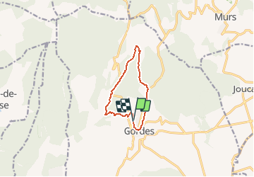
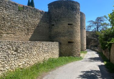
Trail Walking of 8.9 km to be discovered at Provence-Alpes-Côte d'Azur, Vaucluse, Gordes. This trail is proposed by Drailloun.
Description
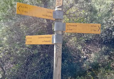
Départ du parking de la Gendarmerie. Après les Dilais, longer les gorges de la Sénancole. Vues plongeantes sur l'Abbaye de Sénanque.
Positioning
Country:
France
Region :
Provence-Alpes-Côte d'Azur
Department/Province :
Vaucluse
Municipality :
Gordes
Location:
Unknown
Start:(Dec)
Start:(UTM)
676428 ; 4864740 (31T) N.
Comments
Trails nearby
![Trail On foot Gordes - les gorges de la Véroncle - Photo](https://media.geolcdn.com/t/375/260/33601979-ee35-45ad-9f22-bd9d0e7a52b1.jpg&format=jpg&maxdim=2)
![On foot On foot](https://static1.geolcdn.com/sitytour/trail-icons/100.png)
les gorges de la Véroncle
On foot
Medium
Gordes,
Provence-Alpes-Côte d'Azur,
Vaucluse,
France
![](/images/other/stat-length.png)
13 km | 17.6 km-effort
3h 59min
![](https://static1.geolcdn.com/siteimages/upload/files/16400158638029165_repeat_loop_refresh_sync_direction_icon.png)
Yes
![Walking Walking](https://static1.geolcdn.com/sitytour/trail-icons/101.png)
PF-Murs - Véroncle, un ravin et des moulins
Walking
Medium
Murs,
Provence-Alpes-Côte d'Azur,
Vaucluse,
France
![](/images/other/stat-length.png)
7.1 km | 9.1 km-effort
2h 4min
![](https://static1.geolcdn.com/siteimages/upload/files/16400158638029165_repeat_loop_refresh_sync_direction_icon.png)
Yes
![Mountain bike Mountain bike](https://static1.geolcdn.com/sitytour/trail-icons/202.png)
activity_9127223965
Mountain bike
Very difficult
Gordes,
Provence-Alpes-Côte d'Azur,
Vaucluse,
France
![](/images/other/stat-length.png)
35 km | 49 km-effort
3h 22min
![](https://static1.geolcdn.com/siteimages/upload/files/16400158638029165_repeat_loop_refresh_sync_direction_icon.png)
Yes
![Mountain bike Mountain bike](https://static1.geolcdn.com/sitytour/trail-icons/202.png)
Gordes_20210913_100058
Mountain bike
Very easy
Gordes,
Provence-Alpes-Côte d'Azur,
Vaucluse,
France
![](/images/other/stat-length.png)
20 km | 27 km-effort
Unknown
![](https://static1.geolcdn.com/siteimages/upload/files/16400158638029165_repeat_loop_refresh_sync_direction_icon.png)
Yes
![Trail Walking Gordes - Gorges de Veroncle au départ de Gordes - Photo](https://media.geolcdn.com/t/375/260/cbfe0509-464e-4f5c-8aea-f3fe9fda94dc.jpg&format=jpg&maxdim=2)
![Walking Walking](https://static1.geolcdn.com/sitytour/trail-icons/101.png)
Gorges de Veroncle au départ de Gordes
Walking
Difficult
Gordes,
Provence-Alpes-Côte d'Azur,
Vaucluse,
France
![](/images/other/stat-length.png)
19.3 km | 26 km-effort
5h 58min
![](https://static1.geolcdn.com/siteimages/upload/files/16400158638029165_repeat_loop_refresh_sync_direction_icon.png)
Yes
![On foot On foot](https://static1.geolcdn.com/sitytour/trail-icons/100.png)
Gordes 10 km
On foot
Difficult
Gordes,
Provence-Alpes-Côte d'Azur,
Vaucluse,
France
![](/images/other/stat-length.png)
9.2 km | 13 km-effort
Unknown
![](https://static1.geolcdn.com/siteimages/upload/files/16400158638029165_repeat_loop_refresh_sync_direction_icon.png)
No
![Trail Walking Cabrières-d'Avignon - Cabrieres les Boujolles - Photo](https://media.geolcdn.com/t/375/260/df96fd5d-a483-47bc-b98c-5989c41c96cb.jpg&format=jpg&maxdim=2)
![Walking Walking](https://static1.geolcdn.com/sitytour/trail-icons/101.png)
Cabrieres les Boujolles
Walking
Difficult
Cabrières-d'Avignon,
Provence-Alpes-Côte d'Azur,
Vaucluse,
France
![](/images/other/stat-length.png)
12.9 km | 17.4 km-effort
6h 27min
![](https://static1.geolcdn.com/siteimages/upload/files/16400158638029165_repeat_loop_refresh_sync_direction_icon.png)
No
![Trail Walking Cabrières-d'Avignon - Cabrières d’Avignon mur de la peste - Photo](https://media.geolcdn.com/t/375/260/277cffe4-e15e-4115-bd3b-6b526cb360de.jpg&format=jpg&maxdim=2)
![Walking Walking](https://static1.geolcdn.com/sitytour/trail-icons/101.png)
Cabrières d’Avignon mur de la peste
Walking
Very easy
Cabrières-d'Avignon,
Provence-Alpes-Côte d'Azur,
Vaucluse,
France
![](/images/other/stat-length.png)
5.2 km | 7.3 km-effort
2h 48min
![](https://static1.geolcdn.com/siteimages/upload/files/16400158638029165_repeat_loop_refresh_sync_direction_icon.png)
Yes
![Trail Walking Joucas - Gorges de Véroncle Via Joucas - Photo](https://media.geolcdn.com/t/375/260/d22eb38c-13a7-4d92-b40f-aa814b45ca9c.jpg&format=jpg&maxdim=2)
![Walking Walking](https://static1.geolcdn.com/sitytour/trail-icons/101.png)
Gorges de Véroncle Via Joucas
Walking
Difficult
Joucas,
Provence-Alpes-Côte d'Azur,
Vaucluse,
France
![](/images/other/stat-length.png)
11.6 km | 16.4 km-effort
3h 43min
![](https://static1.geolcdn.com/siteimages/upload/files/16400158638029165_repeat_loop_refresh_sync_direction_icon.png)
Yes
Belle rando dominicale
belle randonnée avec une très belle vue sur l'abbaye de Senanques mais première moitié dans un sentier difficile car encombré par la végétation