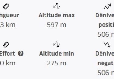
![](/images/other/stat-length.png)
![Trail Walking Carnoules - 19.04.17 Carnoules rando - Photo](https://media.geolcdn.com/t/1900/400/ext.pjpeg?maxdim=2&url=https%3A%2F%2Fservices.sitytrail.com%2FGeolivesWS%2FDownloadMedia.ashx%3FTrailID%3D736022%26Media%3Dfix__20170419153955.jpg)
19.04.17 Carnoules rando
Sugg
User
![Length](/images/other/stat-length.png)
![Max alt](https://static1.geolcdn.com/siteimages/upload/files/1508320355ic_sort_altitude_max_24dp.png)
![Uphill gradient](https://static1.geolcdn.com/siteimages/upload/files/1508320355ic_sort_den_pos_24dp.png)
![Km-Effort](/images/other/stat-length.png)
![Min alt](https://static1.geolcdn.com/siteimages/upload/files/1508320355ic_sort_altitude_min_24dp.png)
![Downhill gradient](https://static1.geolcdn.com/siteimages/upload/files/1508320355ic_sort_den_neg_24dp.png)
![Boucle](https://static1.geolcdn.com/siteimages/upload/files/16400158638029165_repeat_loop_refresh_sync_direction_icon.png)
![Walking](https://static1.geolcdn.com/sitytour/trail-icons/101.png)
5h14
Difficulty : Easy
![Scan this QR Code to open this trail in the SityTrail application](https://capi.geolives.com/qq0zvz2zws4bq2lad0pu/sitytour/trails/736022/qr.png?size=200)
FREE GPS app for hiking
About
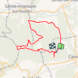
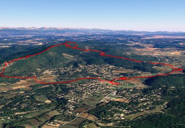
Trail Walking of 18.8 km to be discovered at Provence-Alpes-Côte d'Azur, Var, Carnoules. This trail is proposed by Sugg.
Description
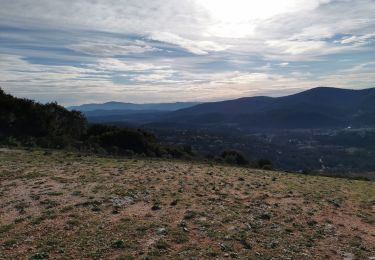
Sur les bases des projets 1 et 2 voici enfin le parcours réel de la rando du 19-04, ( car pas de place au cimetière ).
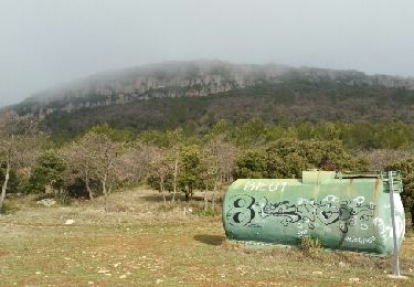
Beau temps.
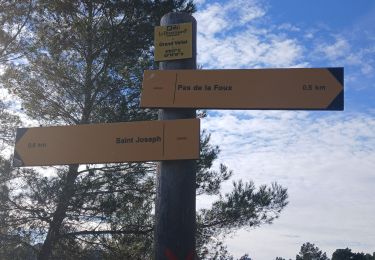
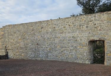
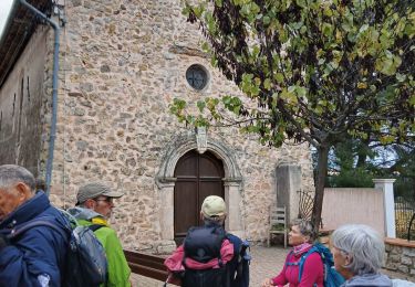
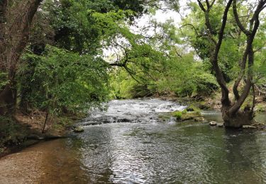
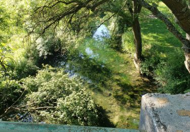
Belle montée au N/O l'Hôpital ( 335 ) pour prendre la piste des Cabrelles, Passage par le Petit Thème ( piste ULM ) et retour par le GR9 avec de beaux points de vue, le trou du Boeuf, les 17 ha du parc photovoltaïque des Narboussiers, ( pas encore sur les cartes ) ND de la Vière et retour en 307.
Positioning
Comments
Trails nearby
![Trail Walking Sainte-Anastasie-sur-Issole - SityTrail - 83 St Quinis grotte chapelle - Photo](https://media.geolcdn.com/t/375/260/855ac779-a3c7-4759-9622-72ff9450b7e1.jpg&format=jpg&maxdim=2)
![Walking Walking](https://static1.geolcdn.com/sitytour/trail-icons/101.png)
Walking
![](/images/other/stat-length.png)
![](https://static1.geolcdn.com/siteimages/upload/files/16400158638029165_repeat_loop_refresh_sync_direction_icon.png)
![Trail Walking Sainte-Anastasie-sur-Issole - St Anastasie St Quinis 2 - Photo](https://media.geolcdn.com/t/375/260/ext.jpg?maxdim=2&url=https%3A%2F%2Fservices.sitytrail.com%2FGeolivesWS%2FDownloadMedia.ashx%3FTrailID%3D901213%26Media%3Dfix__20180207101706.jpg)
![Walking Walking](https://static1.geolcdn.com/sitytour/trail-icons/101.png)
Walking
![](/images/other/stat-length.png)
![](https://static1.geolcdn.com/siteimages/upload/files/16400158638029165_repeat_loop_refresh_sync_direction_icon.png)
![Trail Walking Puget-Ville - ND de la Vière Puget ville 24-01-2025 - Photo](https://media.geolcdn.com/t/375/260/65daf1f6-5c8e-441d-a7ff-dae9a4950388.jpg&format=jpg&maxdim=2)
![Walking Walking](https://static1.geolcdn.com/sitytour/trail-icons/101.png)
Walking
![](/images/other/stat-length.png)
![](https://static1.geolcdn.com/siteimages/upload/files/16400158638029165_repeat_loop_refresh_sync_direction_icon.png)
![Trail Walking Puget-Ville - Puget-ville Sainte Philomène - Photo](https://media.geolcdn.com/t/375/260/2dc2febd-ae0c-4426-b6da-cece7743c366.jpg&format=jpg&maxdim=2)
![Walking Walking](https://static1.geolcdn.com/sitytour/trail-icons/101.png)
Walking
![](/images/other/stat-length.png)
![](https://static1.geolcdn.com/siteimages/upload/files/16400158638029165_repeat_loop_refresh_sync_direction_icon.png)
![Trail Walking Puget-Ville - Les Thèmes- Puget V. 20-11-2024 - Photo](https://media.geolcdn.com/t/375/260/e23e0561-9bb1-480a-87fa-d75c7dbb0cad.jpg&format=jpg&maxdim=2)
![Walking Walking](https://static1.geolcdn.com/sitytour/trail-icons/101.png)
Walking
![](/images/other/stat-length.png)
![](https://static1.geolcdn.com/siteimages/upload/files/16400158638029165_repeat_loop_refresh_sync_direction_icon.png)
![Trail Walking Besse-sur-Issole - Boucle entre Besse et Ste Anastasie sur Issole - Photo](https://media.geolcdn.com/t/375/260/06e3e46b-800e-4c1c-9551-df99b428495c.jpg&format=jpg&maxdim=2)
![Walking Walking](https://static1.geolcdn.com/sitytour/trail-icons/101.png)
Walking
![](/images/other/stat-length.png)
![](https://static1.geolcdn.com/siteimages/upload/files/16400158638029165_repeat_loop_refresh_sync_direction_icon.png)
![Trail Walking Sainte-Anastasie-sur-Issole - Les Ribas-la Clape - Photo](https://media.geolcdn.com/t/375/260/7e0b258a-94e3-48f6-911c-8fa6347d6a29.jpg&format=jpg&maxdim=2)
![Walking Walking](https://static1.geolcdn.com/sitytour/trail-icons/101.png)
Walking
![](/images/other/stat-length.png)
![](https://static1.geolcdn.com/siteimages/upload/files/16400158638029165_repeat_loop_refresh_sync_direction_icon.png)
![Trail Walking Sainte-Anastasie-sur-Issole - Chapelle Saint Quinis depuis Ste Anastasie - Photo](https://media.geolcdn.com/t/375/260/bda9e265-4c31-45c3-bb1e-1209e60a57a1.jpg&format=jpg&maxdim=2)
![Walking Walking](https://static1.geolcdn.com/sitytour/trail-icons/101.png)
Walking
![](/images/other/stat-length.png)
![](https://static1.geolcdn.com/siteimages/upload/files/16400158638029165_repeat_loop_refresh_sync_direction_icon.png)
![Trail Walking Sainte-Anastasie-sur-Issole - chapelle St Quinis - Photo](https://media.geolcdn.com/t/375/260/949dc3ea-7db7-4afc-a918-c50a82a37671.jpg&format=jpg&maxdim=2)
![Walking Walking](https://static1.geolcdn.com/sitytour/trail-icons/101.png)
Walking
![](/images/other/stat-length.png)
![](https://static1.geolcdn.com/siteimages/upload/files/16400158638029165_repeat_loop_refresh_sync_direction_icon.png)