![](/images/other/stat-length.png)
![Trail Walking Dieffenthal - Boucle Dieffenthal - Ramstein - Photo](https://media.geolcdn.com/t/1900/400/ext.pjpeg?maxdim=2&url=https%3A%2F%2Fstatic1.geolcdn.com%2Fsiteimages%2Fupload%2Ffiles%2F1553511878bg_sport_marche.png)
Boucle Dieffenthal - Ramstein
zazie
User
![Length](/images/other/stat-length.png)
Length
15.7 km
![Max alt](https://static1.geolcdn.com/siteimages/upload/files/1508320355ic_sort_altitude_max_24dp.png)
Max alt
566 m
![Uphill gradient](https://static1.geolcdn.com/siteimages/upload/files/1508320355ic_sort_den_pos_24dp.png)
Uphill gradient
689 m
![Km-Effort](/images/other/stat-length.png)
Km-Effort
24 km
![Min alt](https://static1.geolcdn.com/siteimages/upload/files/1508320355ic_sort_altitude_min_24dp.png)
Min alt
213 m
![Downhill gradient](https://static1.geolcdn.com/siteimages/upload/files/1508320355ic_sort_den_neg_24dp.png)
Downhill gradient
520 m
![Boucle](https://static1.geolcdn.com/siteimages/upload/files/16400158638029165_repeat_loop_refresh_sync_direction_icon.png)
Boucle
No
Creation date :
2017-04-14 00:00:00.0
Updated on :
2017-04-14 00:00:00.0
![Walking](https://static1.geolcdn.com/sitytour/trail-icons/101.png)
3h04
Difficulty : Easy
![Scan this QR Code to open this trail in the SityTrail application](https://capi.geolives.com/qq0zvz2zws4bq2lad0pu/sitytour/trails/732507/qr.png?size=200)
FREE GPS app for hiking
About
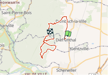
Trail Walking of 15.7 km to be discovered at Grand Est, Bas-Rhin, Dieffenthal. This trail is proposed by zazie.
Description
Randonnée pour ados et plus. Enregistrement non terminé suite problème batterie. Depuis la Wolfskirche, redescendre en suivant les panneaux Dieffenthal ou le sentier Murailles et vignes.
Positioning
Country:
France
Region :
Grand Est
Department/Province :
Bas-Rhin
Municipality :
Dieffenthal
Location:
Unknown
Start:(Dec)
Start:(UTM)
382606 ; 5351856 (32U) N.
Comments
Trails nearby
![Trail Walking Dambach-la-Ville - Les ruines de Bernstein et d'Ortenbourg par la forêt - Photo](https://media.geolcdn.com/t/375/260/ext.jpg?maxdim=2&url=https%3A%2F%2Fservices.sitytrail.com%2FGeolivesWS%2FDownloadMedia.ashx%3FTrailID%3D409858%26Media%3Dfix__20150419145401.jpg)
![Walking Walking](https://static1.geolcdn.com/sitytour/trail-icons/101.png)
Les ruines de Bernstein et d'Ortenbourg par la forêt
Walking
Medium
(1)
Dambach-la-Ville,
Grand Est,
Bas-Rhin,
France
![](/images/other/stat-length.png)
13 km | 18.5 km-effort
4h 38min
![](https://static1.geolcdn.com/siteimages/upload/files/16400158638029165_repeat_loop_refresh_sync_direction_icon.png)
Yes
![Trail Walking Châtenois - Le Hahnenberg et les balcons Sélestat - Photo](https://media.geolcdn.com/t/375/260/ext.jpg?maxdim=2&url=https%3A%2F%2Fservices.sitytrail.com%2FGeolivesWS%2FDownloadMedia.ashx%3FTrailID%3D160509%26Media%3D20121030151326.jpeg)
![Walking Walking](https://static1.geolcdn.com/sitytour/trail-icons/101.png)
Le Hahnenberg et les balcons Sélestat
Walking
Medium
(2)
Châtenois,
Grand Est,
Bas-Rhin,
France
![](/images/other/stat-length.png)
12 km | 17.2 km-effort
4h 29min
![](https://static1.geolcdn.com/siteimages/upload/files/16400158638029165_repeat_loop_refresh_sync_direction_icon.png)
Yes
![Trail Equestrian Saint-Pierre-Bois - St Pierre Bois - Ortembourg 14062014 - Photo](https://media.geolcdn.com/t/375/260/ext.jpg?maxdim=2&url=https%3A%2F%2Fservices.sitytrail.com%2FGeolivesWS%2FDownloadMedia.ashx%3FTrailID%3D312649%26Media%3Dfix__20140429145527.jpg)
![Equestrian Equestrian](https://static1.geolcdn.com/sitytour/trail-icons/300.png)
St Pierre Bois - Ortembourg 14062014
Equestrian
Very easy
(1)
Saint-Pierre-Bois,
Grand Est,
Bas-Rhin,
France
![](/images/other/stat-length.png)
25 km | 36 km-effort
5h 14min
![](https://static1.geolcdn.com/siteimages/upload/files/16400158638029165_repeat_loop_refresh_sync_direction_icon.png)
Yes
![Trail Walking Scherwiller - chateau de ortenbourg - Photo](https://media.geolcdn.com/t/375/260/ext.jpg?maxdim=2&url=https%3A%2F%2Fstatic1.geolcdn.com%2Fsiteimages%2Fupload%2Ffiles%2F1553511878bg_sport_marche.png)
![Walking Walking](https://static1.geolcdn.com/sitytour/trail-icons/101.png)
chateau de ortenbourg
Walking
Very easy
(1)
Scherwiller,
Grand Est,
Bas-Rhin,
France
![](/images/other/stat-length.png)
4.6 km | 7.9 km-effort
1h 29min
![](https://static1.geolcdn.com/siteimages/upload/files/16400158638029165_repeat_loop_refresh_sync_direction_icon.png)
Yes
![Trail Walking Châtenois - Le Haut Koenigsbourg de Val de Ville - Photo](https://media.geolcdn.com/t/375/260/ext.jpg?maxdim=2&url=https%3A%2F%2Fservices.sitytrail.com%2FGeolivesWS%2FDownloadMedia.ashx%3FTrailID%3D101918%26Media%3D2205_1.jpg)
![Walking Walking](https://static1.geolcdn.com/sitytour/trail-icons/101.png)
Le Haut Koenigsbourg de Val de Ville
Walking
Difficult
(1)
Châtenois,
Grand Est,
Bas-Rhin,
France
![](/images/other/stat-length.png)
16.8 km | 25 km-effort
5h 0min
![](https://static1.geolcdn.com/siteimages/upload/files/16400158638029165_repeat_loop_refresh_sync_direction_icon.png)
Yes
![Trail Mountain bike Thanvillé - Circuit de la Gadouille - Photo](https://media.geolcdn.com/t/375/260/ext.jpg?maxdim=2&url=https%3A%2F%2Fservices.sitytrail.com%2FGeolivesWS%2FDownloadMedia.ashx%3FTrailID%3D101135%26Media%3D622_1.jpg)
![Mountain bike Mountain bike](https://static1.geolcdn.com/sitytour/trail-icons/202.png)
Circuit de la Gadouille
Mountain bike
Difficult
(3)
Thanvillé,
Grand Est,
Bas-Rhin,
France
![](/images/other/stat-length.png)
18.4 km | 27 km-effort
1h 40min
![](https://static1.geolcdn.com/siteimages/upload/files/16400158638029165_repeat_loop_refresh_sync_direction_icon.png)
Yes
![Trail Walking Dambach-la-Ville - suuntoapp-Hiking-2023-12-26T08-42-47Z - Photo](https://media.geolcdn.com/t/375/260/72166c10-841b-4acc-9a04-0ef640ea51f0.jpg&format=jpg&maxdim=2)
![Walking Walking](https://static1.geolcdn.com/sitytour/trail-icons/101.png)
suuntoapp-Hiking-2023-12-26T08-42-47Z
Walking
Very difficult
Dambach-la-Ville,
Grand Est,
Bas-Rhin,
France
![](/images/other/stat-length.png)
14.3 km | 21 km-effort
4h 43min
![](https://static1.geolcdn.com/siteimages/upload/files/16400158638029165_repeat_loop_refresh_sync_direction_icon.png)
Yes
![Trail Trail Dambach-la-Ville - 2023-05-01 Course Trail Tous au Bernstein - Photo](https://media.geolcdn.com/t/375/260/a3614ece-6347-45c6-985f-834886411dae.jpg&format=jpg&maxdim=2)
![Trail Trail](https://static1.geolcdn.com/sitytour/trail-icons/104.png)
2023-05-01 Course Trail Tous au Bernstein
Trail
Difficult
(1)
Dambach-la-Ville,
Grand Est,
Bas-Rhin,
France
![](/images/other/stat-length.png)
24 km | 39 km-effort
3h 11min
![](https://static1.geolcdn.com/siteimages/upload/files/16400158638029165_repeat_loop_refresh_sync_direction_icon.png)
Yes
![Trail Walking Scherwiller - Scherwiller - Chateaux Ramstein-Ortenbourg-Berstein 2022-10 - Photo](https://media.geolcdn.com/t/375/260/2163c1a8-b02b-4f2c-aaa3-de2f4e89bdfa.jpg&format=jpg&maxdim=2)
![Walking Walking](https://static1.geolcdn.com/sitytour/trail-icons/101.png)
Scherwiller - Chateaux Ramstein-Ortenbourg-Berstein 2022-10
Walking
Easy
Scherwiller,
Grand Est,
Bas-Rhin,
France
![](/images/other/stat-length.png)
14.5 km | 22 km-effort
3h 13min
![](https://static1.geolcdn.com/siteimages/upload/files/16400158638029165_repeat_loop_refresh_sync_direction_icon.png)
Yes