![](/images/other/stat-length.png)
![Trail Walking Profondeville - Lustin Bob G...9-4-2017 - Photo](https://media.geolcdn.com/t/1900/400/ext.pjpeg?maxdim=2&url=https%3A%2F%2Fstatic1.geolcdn.com%2Fsiteimages%2Fupload%2Ffiles%2F1553511878bg_sport_marche.png)
Lustin Bob G...9-4-2017
r.genette
User
![Length](/images/other/stat-length.png)
Length
10.2 km
![Max alt](https://static1.geolcdn.com/siteimages/upload/files/1508320355ic_sort_altitude_max_24dp.png)
Max alt
277 m
![Uphill gradient](https://static1.geolcdn.com/siteimages/upload/files/1508320355ic_sort_den_pos_24dp.png)
Uphill gradient
205 m
![Km-Effort](/images/other/stat-length.png)
Km-Effort
12.9 km
![Min alt](https://static1.geolcdn.com/siteimages/upload/files/1508320355ic_sort_altitude_min_24dp.png)
Min alt
183 m
![Downhill gradient](https://static1.geolcdn.com/siteimages/upload/files/1508320355ic_sort_den_neg_24dp.png)
Downhill gradient
205 m
![Boucle](https://static1.geolcdn.com/siteimages/upload/files/16400158638029165_repeat_loop_refresh_sync_direction_icon.png)
Boucle
Yes
Creation date :
2017-07-08 00:00:00.0
Updated on :
2017-07-08 00:00:00.0
![Walking](https://static1.geolcdn.com/sitytour/trail-icons/101.png)
2h20
Difficulty : Medium
![Scan this QR Code to open this trail in the SityTrail application](https://capi.geolives.com/qq0zvz2zws4bq2lad0pu/sitytour/trails/730325/qr.png?size=200)
FREE GPS app for hiking
About
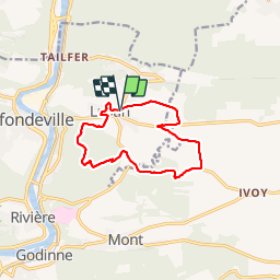
Trail Walking of 10.2 km to be discovered at Wallonia, Namur, Profondeville. This trail is proposed by r.genette.
Description
Découverte du village par des petits chemins, très beaux sentiers dans le bois de Nimes, passage près de la ferme du trou d'Haquin, bois de Biamont, tri d'Ivoy, ferme de Marconvaux, Les Dossias et retour par Chap. St-Donat..(Sonia Baily resp de la marche)
Positioning
Country:
Belgium
Region :
Wallonia
Department/Province :
Namur
Municipality :
Profondeville
Location:
Lustin
Start:(Dec)
Start:(UTM)
635107 ; 5582519 (31U) N.
Comments
Trails nearby
![Trail Walking Profondeville - GG-Na-19_ Lustin - Namur - Photo](https://media.geolcdn.com/t/375/260/ext.jpg?maxdim=2&url=https%3A%2F%2Fmedia.geolcdn.com%2Ff%2Fb0b5ef2e-bf0c-4965-a3a2-62d0da2d07c7.jpg)
![Walking Walking](https://static1.geolcdn.com/sitytour/trail-icons/101.png)
GG-Na-19_ Lustin - Namur
Walking
Very difficult
(13)
Profondeville,
Wallonia,
Namur,
Belgium
![](/images/other/stat-length.png)
22 km | 28 km-effort
6h 7min
![](https://static1.geolcdn.com/siteimages/upload/files/16400158638029165_repeat_loop_refresh_sync_direction_icon.png)
No
![Trail Walking Yvoir - RB-Na-21-Terres seigneuriales et carrières de la vallée du Bocq - Photo](https://media.geolcdn.com/t/375/260/ext.jpg?maxdim=2&url=https%3A%2F%2Fmedia.geolcdn.com%2Ff%2F77bdfe07-c4c1-4d1b-a54a-f48ca19ed07c.JPG)
![Walking Walking](https://static1.geolcdn.com/sitytour/trail-icons/101.png)
RB-Na-21-Terres seigneuriales et carrières de la vallée du Bocq
Walking
Very difficult
(6)
Yvoir,
Wallonia,
Namur,
Belgium
![](/images/other/stat-length.png)
22 km | 30 km-effort
6h 51min
![](https://static1.geolcdn.com/siteimages/upload/files/16400158638029165_repeat_loop_refresh_sync_direction_icon.png)
Yes
![Trail Walking Profondeville - RB-Na-20-Raccourci-2_Paysages_entre_Meuse_et_Burnot - Photo](https://media.geolcdn.com/t/375/260/ext.jpg?maxdim=2&url=https%3A%2F%2Fmedia.geolcdn.com%2Ff%2F8204f516-cdb2-4e3b-8381-1ddcd8c9015d.JPG)
![Walking Walking](https://static1.geolcdn.com/sitytour/trail-icons/101.png)
RB-Na-20-Raccourci-2_Paysages_entre_Meuse_et_Burnot
Walking
Very difficult
(11)
Profondeville,
Wallonia,
Namur,
Belgium
![](/images/other/stat-length.png)
14.6 km | 22 km-effort
4h 53min
![](https://static1.geolcdn.com/siteimages/upload/files/16400158638029165_repeat_loop_refresh_sync_direction_icon.png)
Yes
![Trail Walking Profondeville - RB-Na-20-Paysages_entre_Meuse_et_Burnot - Photo](https://media.geolcdn.com/t/375/260/ext.jpg?maxdim=2&url=https%3A%2F%2Fmedia.geolcdn.com%2Ff%2F62b35a3a-8c39-4ffb-925a-863a1d62e013.JPG)
![Walking Walking](https://static1.geolcdn.com/sitytour/trail-icons/101.png)
RB-Na-20-Paysages_entre_Meuse_et_Burnot
Walking
Very difficult
(15)
Profondeville,
Wallonia,
Namur,
Belgium
![](/images/other/stat-length.png)
18.5 km | 26 km-effort
5h 55min
![](https://static1.geolcdn.com/siteimages/upload/files/16400158638029165_repeat_loop_refresh_sync_direction_icon.png)
Yes
![Trail Walking Assesse - RB-Na-02 Raccourci - Les collines de la vallée du Bocq - Photo](https://media.geolcdn.com/t/375/260/ext.jpg?maxdim=2&url=https%3A%2F%2Fservices.sitytrail.com%2FGeolivesWS%2FDownloadMedia.ashx%3FTrailID%3D794014%26Media%3Dc4c97e29-7bfb-495c-ae56-13528ce8d0b3.JPG)
![Walking Walking](https://static1.geolcdn.com/sitytour/trail-icons/101.png)
RB-Na-02 Raccourci - Les collines de la vallée du Bocq
Walking
Medium
(7)
Assesse,
Wallonia,
Namur,
Belgium
![](/images/other/stat-length.png)
17 km | 23 km-effort
5h 32min
![](https://static1.geolcdn.com/siteimages/upload/files/16400158638029165_repeat_loop_refresh_sync_direction_icon.png)
Yes
![Trail Walking Assesse - RB-Na-02 Les collines de la vallée du Bocq - Photo](https://media.geolcdn.com/t/375/260/ext.jpg?maxdim=2&url=https%3A%2F%2Fservices.sitytrail.com%2FGeolivesWS%2FDownloadMedia.ashx%3FTrailID%3D250531%26Media%3Dc4c97e29-7bfb-495c-ae56-13528ce8d0b3.JPG)
![Walking Walking](https://static1.geolcdn.com/sitytour/trail-icons/101.png)
RB-Na-02 Les collines de la vallée du Bocq
Walking
Medium
(20)
Assesse,
Wallonia,
Namur,
Belgium
![](/images/other/stat-length.png)
21 km | 28 km-effort
5h 32min
![](https://static1.geolcdn.com/siteimages/upload/files/16400158638029165_repeat_loop_refresh_sync_direction_icon.png)
Yes
![Trail Walking Assesse - 05 Paysage condruzien - Photo](https://media.geolcdn.com/t/375/260/ext.jpg?maxdim=2&url=https%3A%2F%2Fservices.sitytrail.com%2FGeolivesWS%2FDownloadMedia.ashx%3FTrailID%3D121392%26Media%3D31d83d0c-5bcd-44cd-b8d6-1cc6a3d25bf9.jpg)
![Walking Walking](https://static1.geolcdn.com/sitytour/trail-icons/101.png)
05 Paysage condruzien
Walking
Easy
(5)
Assesse,
Wallonia,
Namur,
Belgium
![](/images/other/stat-length.png)
10.2 km | 13.3 km-effort
2h 11min
![](https://static1.geolcdn.com/siteimages/upload/files/16400158638029165_repeat_loop_refresh_sync_direction_icon.png)
No
![Trail Walking Yvoir - GG2-Na-38_Godinne-Dinant (2021-11-04) - Photo](https://media.geolcdn.com/t/375/260/ext.jpg?maxdim=2&url=https%3A%2F%2Fmedia.geolcdn.com%2Ff%2F4b7f8162-b405-4557-afe1-7567462c4aff.jpg)
![Walking Walking](https://static1.geolcdn.com/sitytour/trail-icons/101.png)
GG2-Na-38_Godinne-Dinant (2021-11-04)
Walking
Very difficult
(6)
Yvoir,
Wallonia,
Namur,
Belgium
![](/images/other/stat-length.png)
19.5 km | 27 km-effort
6h 13min
![](https://static1.geolcdn.com/siteimages/upload/files/16400158638029165_repeat_loop_refresh_sync_direction_icon.png)
No
![Trail Walking Anhée - RF-Na-05 Annevoie, côté Jardins_Grande-boucle - Photo](https://media.geolcdn.com/t/375/260/ext.jpg?maxdim=2&url=https%3A%2F%2Fservices.sitytrail.com%2FGeolivesWS%2FDownloadMedia.ashx%3FTrailID%3D545753%26Media%3D5d973c83-4a6c-40fc-a026-25de6c754887.JPG)
![Walking Walking](https://static1.geolcdn.com/sitytour/trail-icons/101.png)
RF-Na-05 Annevoie, côté Jardins_Grande-boucle
Walking
Medium
(11)
Anhée,
Wallonia,
Namur,
Belgium
![](/images/other/stat-length.png)
11.3 km | 14.5 km-effort
3h 6min
![](https://static1.geolcdn.com/siteimages/upload/files/16400158638029165_repeat_loop_refresh_sync_direction_icon.png)
Yes