![](/images/other/stat-length.png)
![Trail Walking Bucy-Saint-Liphard - LA Canudiere Parcours N° 1 - Photo](https://media.geolcdn.com/t/1900/400/ext.pjpeg?maxdim=2&url=https%3A%2F%2Fstatic1.geolcdn.com%2Fsiteimages%2Fupload%2Ffiles%2F1553511878bg_sport_marche.png)
LA Canudiere Parcours N° 1
rando45
User
![Length](/images/other/stat-length.png)
Length
15.2 km
![Max alt](https://static1.geolcdn.com/siteimages/upload/files/1508320355ic_sort_altitude_max_24dp.png)
Max alt
125 m
![Uphill gradient](https://static1.geolcdn.com/siteimages/upload/files/1508320355ic_sort_den_pos_24dp.png)
Uphill gradient
109 m
![Km-Effort](/images/other/stat-length.png)
Km-Effort
16.6 km
![Min alt](https://static1.geolcdn.com/siteimages/upload/files/1508320355ic_sort_altitude_min_24dp.png)
Min alt
101 m
![Downhill gradient](https://static1.geolcdn.com/siteimages/upload/files/1508320355ic_sort_den_neg_24dp.png)
Downhill gradient
109 m
![Boucle](https://static1.geolcdn.com/siteimages/upload/files/16400158638029165_repeat_loop_refresh_sync_direction_icon.png)
Boucle
Yes
Creation date :
2017-04-07 00:00:00.0
Updated on :
2017-04-07 00:00:00.0
![Walking](https://static1.geolcdn.com/sitytour/trail-icons/101.png)
3h21
Difficulty : Medium
![Scan this QR Code to open this trail in the SityTrail application](https://capi.geolives.com/qq0zvz2zws4bq2lad0pu/sitytour/trails/728406/qr.png?size=200)
FREE GPS app for hiking
About
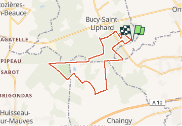
Trail Walking of 15.2 km to be discovered at Centre-Loire Valley, Loiret, Bucy-Saint-Liphard. This trail is proposed by rando45.
Description
Départ du Centre de Loisirs de la Canaudière en passant par les communes de Huisseau sur Mauves , Chaingy , et Bucy Saint Liphard . Tout cela sous les chants des oiseaux
Positioning
Country:
France
Region :
Centre-Loire Valley
Department/Province :
Loiret
Municipality :
Bucy-Saint-Liphard
Location:
Unknown
Start:(Dec)
Start:(UTM)
409171 ; 5308911 (31T) N.
Comments
Trails nearby
![Trail Walking Ingré - Ingré - Photo](https://media.geolcdn.com/t/375/260/ext.jpg?maxdim=2&url=https%3A%2F%2Fservices.sitytrail.com%2FGeolivesWS%2FDownloadMedia.ashx%3FTrailID%3D559602%26Media%3Dfix__20160417094813.jpg)
![Walking Walking](https://static1.geolcdn.com/sitytour/trail-icons/101.png)
![Trail Other activity Bucy-Saint-Liphard - canaudiere - Photo](https://media.geolcdn.com/t/375/260/ext.jpg?maxdim=2&url=https%3A%2F%2Fstatic1.geolcdn.com%2Fsiteimages%2Fupload%2Ffiles%2F1545311037marcheuse_200dpi.jpg)
![Other activity Other activity](https://static1.geolcdn.com/sitytour/trail-icons/900.png)
canaudiere
Other activity
Very easy
Bucy-Saint-Liphard,
Centre-Loire Valley,
Loiret,
France
![](/images/other/stat-length.png)
4.6 km | 5 km-effort
1h 29min
![](https://static1.geolcdn.com/siteimages/upload/files/16400158638029165_repeat_loop_refresh_sync_direction_icon.png)
Yes
![Trail Walking Bucy-Saint-Liphard - Ormes La Canaudiere - Photo](https://media.geolcdn.com/t/375/260/ext.jpg?maxdim=2&url=https%3A%2F%2Fstatic1.geolcdn.com%2Fsiteimages%2Fupload%2Ffiles%2F1553511878bg_sport_marche.png)
![Walking Walking](https://static1.geolcdn.com/sitytour/trail-icons/101.png)
Ormes La Canaudiere
Walking
Easy
Bucy-Saint-Liphard,
Centre-Loire Valley,
Loiret,
France
![](/images/other/stat-length.png)
10.9 km | 11.8 km-effort
2h 37min
![](https://static1.geolcdn.com/siteimages/upload/files/16400158638029165_repeat_loop_refresh_sync_direction_icon.png)
Yes
![Trail Cycle La Chapelle-Saint-Mesmin - glups - Photo](https://media.geolcdn.com/t/375/260/ext.jpg?maxdim=2&url=https%3A%2F%2Fstatic1.geolcdn.com%2Fsiteimages%2Fupload%2Ffiles%2F1524743154velo.jpg)
![Cycle Cycle](https://static1.geolcdn.com/sitytour/trail-icons/200.png)
glups
Cycle
Very easy
La Chapelle-Saint-Mesmin,
Centre-Loire Valley,
Loiret,
France
![](/images/other/stat-length.png)
68 km | 73 km-effort
3h 10min
![](https://static1.geolcdn.com/siteimages/upload/files/16400158638029165_repeat_loop_refresh_sync_direction_icon.png)
Yes
![Trail Mountain bike Ormes - Rando des Ormes 2004 - Photo](https://media.geolcdn.com/t/375/260/ext.jpg?maxdim=2&url=https%3A%2F%2Fservices.sitytrail.com%2FGeolivesWS%2FDownloadMedia.ashx%3FTrailID%3D100917%26Media%3D417_1.jpg)
![Mountain bike Mountain bike](https://static1.geolcdn.com/sitytour/trail-icons/202.png)
Rando des Ormes 2004
Mountain bike
Very difficult
Ormes,
Centre-Loire Valley,
Loiret,
France
![](/images/other/stat-length.png)
62 km | 67 km-effort
4h 0min
![](https://static1.geolcdn.com/siteimages/upload/files/16400158638029165_repeat_loop_refresh_sync_direction_icon.png)
Yes
![Trail Cycle Ingré - marché saint Jean de la ruelle - Photo](https://media.geolcdn.com/t/375/260/ext.jpg?maxdim=2&url=https%3A%2F%2Fstatic1.geolcdn.com%2Fsiteimages%2Fupload%2Ffiles%2F1524743154velo.jpg)
![Cycle Cycle](https://static1.geolcdn.com/sitytour/trail-icons/200.png)
marché saint Jean de la ruelle
Cycle
Very easy
Ingré,
Centre-Loire Valley,
Loiret,
France
![](/images/other/stat-length.png)
5.9 km | 6.4 km-effort
Unknown
![](https://static1.geolcdn.com/siteimages/upload/files/16400158638029165_repeat_loop_refresh_sync_direction_icon.png)
No
![Trail Walking Bucy-Saint-Liphard - Ormes - La Canaudiere - Photo](https://media.geolcdn.com/t/375/260/ext.jpg?maxdim=2&url=https%3A%2F%2Fstatic1.geolcdn.com%2Fsiteimages%2Fupload%2Ffiles%2F1553511878bg_sport_marche.png)
![Walking Walking](https://static1.geolcdn.com/sitytour/trail-icons/101.png)
Ormes - La Canaudiere
Walking
Very easy
Bucy-Saint-Liphard,
Centre-Loire Valley,
Loiret,
France
![](/images/other/stat-length.png)
10.8 km | 11.7 km-effort
2h 39min
![](https://static1.geolcdn.com/siteimages/upload/files/16400158638029165_repeat_loop_refresh_sync_direction_icon.png)
Yes
![Trail Walking Ingré - ingre1 - Photo](https://media.geolcdn.com/t/375/260/ext.jpg?maxdim=2&url=https%3A%2F%2Fstatic1.geolcdn.com%2Fsiteimages%2Fupload%2Ffiles%2F1553511878bg_sport_marche.png)
![Walking Walking](https://static1.geolcdn.com/sitytour/trail-icons/101.png)