


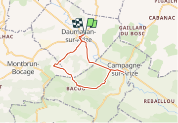


17.2 km | 24 km-effort


User


FREE GPS app for hiking
 SityTrail
IGN / Geographical institutes
SityTrail World
The world is yours!
Trail Walking of 12.5 km to be discovered at Occitania, Ariège, Daumazan-sur-Arize. This trail is proposed by pidjam.
Après une visite de la ville de Daumazan et son église particulière, vous marcherez dans la campagne vallonnée en contournant les propriétés privées (balisage jaune parfois difficile à trouver ou manquant)

Mountain bike

Walking

On foot

On foot

Walking

Cycle
Cycle
Walking