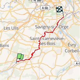
23 km | 29 km-effort
La vallée de l'orge
kraken
User
Length
35 km
Max alt
84 m
Uphill gradient
312 m
Km-Effort
39 km
Min alt
33 m
Downhill gradient
331 m
Boucle
No
Creation date :
2014-12-10 00:00:00.0
Updated on :
2014-12-10 00:00:00.0
--
Difficulty : Very easy
FREE GPS app for hiking
About
Trail Walking of 35 km to be discovered at Ile-de-France, Essonne, Breuillet. This trail is proposed by kraken.
Description
Randonnée tus le long de l'orge, de Bruyére-le-chatel a Athis mons.
Positioning
Country:
France
Region :
Ile-de-France
Department/Province :
Essonne
Municipality :
Breuillet
Location:
Unknown
Start:(Dec)
Start:(UTM)
440376 ; 5380785 (31U) N.
Comments
Trails nearby
Les Pétales de Souzy
Walking
Difficult
(1)
Saint-Sulpice-de-Favières,
Ile-de-France,
Essonne,
France
4h 49min
Yes
Boucle Fontenay les Briis
Walking
Very easy
Bruyères-le-Châtel,
Ile-de-France,
Essonne,
France
22 km | 26 km-effort
5h 4min
Yes
Boucle St Maurice Montcouronne - Brigitte
Walking
Very easy
Saint-Maurice-Montcouronne,
Ile-de-France,
Essonne,
France
21 km | 24 km-effort
4h 19min
Yes
Sur les traces de la Renarde
On foot
Very difficult
Saint-Yon,
Ile-de-France,
Essonne,
France
38 km | 44 km-effort
10h 4min
No
St Sulpice
Walking
Medium
(1)
Saint-Sulpice-de-Favières,
Ile-de-France,
Essonne,
France
8 km | 10.1 km-effort
2h 18min
Yes
Soucy / Le Marais
Mountain bike
Medium
(2)
Fontenay-lès-Briis,
Ile-de-France,
Essonne,
France
25 km | 30 km-effort
1h 52min
Yes
Carrière de Madagascar
Walking
Very easy
(1)
Boissy-sous-Saint-Yon,
Ile-de-France,
Essonne,
France
13.2 km | 16.5 km-effort
2h 59min
Yes
Saint-Cheron - l'Orge
Walking
Medium
Saint-Chéron,
Ile-de-France,
Essonne,
France
8.3 km | 10.4 km-effort
2h 21min
Yes
De Saint Chéron à Dourdan par les côteaux de la rive gauche
Walking
Difficult
(1)
Saint-Chéron,
Ile-de-France,
Essonne,
France
13.5 km | 17 km-effort
3h 51min
No