Trail Other activity Colombé-le-Sec - colombé le sec 20 km - Photo

colombé le sec 20 km

 rvapeldo
rvapeldo

User GUIDE

© OpenStreetMap contributors
Length
Length
22 km
Max alt
Max alt
324 m
Uphill gradient
Uphill gradient
384 m
Km-Effort
Km-Effort  
27 km
Min alt
Min alt
160 m
Downhill gradient
Downhill gradient
387 m
Boucle
Boucle
Yes
Creation date :
2018-10-06 08:28:41.203
Updated on :
2018-10-06 08:28:41.257

(0 Reviews)

Other activity
Other activity
6h42
Difficulty : Easy

Scan this QR Code to open this trail in the SityTrail application

FREE GPS app for hiking

Logo SityTrail SityTrail

IGN / Geographical institutes

Download SityTrail from the App Store Download SityTrail from Google Play

Logo SityTrail SityTrail World

The world is yours!

Download SityTrail from the App Store Download SityTrail from Google Play Download SityTrail on Huawei AppGallery

About

Trail Other activity of 22 km to be discovered at Grand Est, Aube, Colombé-le-Sec. This trail is proposed by rvapeldo.

Elevation profile

Positioning

Country:
France
Region :
Grand Est
Department/Province :
Aube
Municipality :
Colombé-le-Sec
Location:
Unknown
Start:(UTM)
633287 ; 5346235 (31U) N.

Trails nearby

Trail On foot Colombé-le-Sec - Circuit Gaston Cheq - Photo
On foot
PRO

On foot

Medium
Colombé-le-Sec, Grand Est, Aube, France
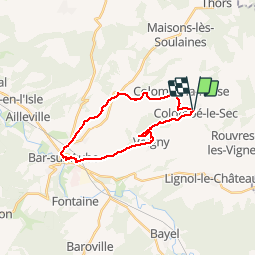
20 km | 26 km-effort
5h 53min
No
Trail Mountain bike Arrentières - quad arrentiere - Photo
Mountain bike
stlvain

Mountain bike

Very difficult
Arrentières, Grand Est, Aube, France
69 km | 86 km-effort
141h 8min
Yes
Trail Quad Arrentières - arentieres - Photo
Quad
powerdu21

Quad

Very easy
Arrentières, Grand Est, Aube, France
100 km | 128 km-effort
8h 20min
Yes
Trail Mountain bike Lévigny - baralbike LEVIGNY 2013 - Photo
Mountain bike
Tollard

Mountain bike

Very difficult
Lévigny, Grand Est, Aube, France
59 km | 73 km-effort
4h 40min
Yes


Close
My subscriptions