Trail Mountain bike Brou-sur-Chantereine - 2011-08-15 Vilevaudé-chemin de la d'Huys- foret de Bondy  - Photo

2011-08-15 Vilevaudé-chemin de la d'Huys- foret de Bondy

 dufdom
dufdom

User

© OpenStreetMap contributors
Length
Length
31 km
Max alt
Max alt
133 m
Uphill gradient
Uphill gradient
313 m
Km-Effort
Km-Effort  
35 km
Min alt
Min alt
48 m
Downhill gradient
Downhill gradient
312 m
Boucle
Boucle
No
Creation date :
2014-12-10 00:00:00.0
Updated on :
2014-12-10 00:00:00.0

(0 Reviews)

Mountain bike
Mountain bike
2h03
Difficulty : Easy

Scan this QR Code to open this trail in the SityTrail application

FREE GPS app for hiking

Logo SityTrail SityTrail

IGN / Geographical institutes

Download SityTrail from the App Store Download SityTrail from Google Play

Logo SityTrail SityTrail World

The world is yours!

Download SityTrail from the App Store Download SityTrail from Google Play Download SityTrail on Huawei AppGallery

About

Trail Mountain bike of 31 km to be discovered at Ile-de-France, Seine-et-Marne, Brou-sur-Chantereine. This trail is proposed by dufdom.

Elevation profile

Photos

Points of interest

Point of interest Le Pin - d'Huys - Photo
dufdom
LE PIN 
Point of interest Le Pin - tunnel  - Photo
dufdom
LE PIN 
Point of interest Clichy-sous-Bois - forêt de Bondy - Photo
dufdom
CLICHY-SOUS-BOIS 

Positioning

Country:
France
Region :
Ile-de-France
Department/Province :
Seine-et-Marne
Municipality :
Brou-sur-Chantereine
Location:
Unknown
Start:(UTM)
472799 ; 5415157 (31U) N.

Trails nearby

Trail Walking Chelles - GRP CV-IDF 06 - Photo
Walking
clalaur

Walking

Medium
(1)
Chelles, Ile-de-France, Seine-et-Marne, France
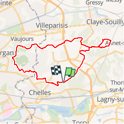
15 km | 16.7 km-effort
3h 47min
No
Trail Walking Saint-Thibault-des-Vignes - Du Parc de Rentilly au Ru de la Gondoire - Photo
Walking

Walking

Difficult
(1)
Saint-Thibault-des-Vignes, Ile-de-France, Seine-et-Marne, France
21 km | 24 km-effort
5h 20min
Yes
Trail Walking Bussy-Saint-Georges - Boucle Rentilly - Noisiel - Etang de la Brosse - Etang de la Loy - Photo
Walking
GUIDE
chessyca

Walking

Very difficult
Bussy-Saint-Georges, Ile-de-France, Seine-et-Marne, France
25 km | 29 km-effort
6h 32min
Yes
Trail Walking Villevaudé - SityTrail - GR15 ttrace - Photo
Walking
clalaur

Walking

Very difficult
(1)
Villevaudé, Ile-de-France, Seine-et-Marne, France
18.5 km | 21 km-effort
4h 44min
No
Trail Walking Vaires-sur-Marne - Boucle Vaires sur Marne / Noisiel / Chelles - Photo
Walking
GUIDE
chessyca

Walking

Easy
Vaires-sur-Marne, Ile-de-France, Seine-et-Marne, France
21 km | 24 km-effort
4h 33min
Yes
Trail Walking Gournay-sur-Marne - Boucle Gournay/ Marne - Noisy le Grand - Champs sur Marne - Photo
Walking
GUIDE
chessyca

Walking

Very easy
Gournay-sur-Marne, Ile-de-France, Seine-Saint-Denis, France
20 km | 23 km-effort
4h 41min
Yes
Trail Walking Saint-Thibault-des-Vignes - Du Parc de Rentilly au Vallon de la Brosse - Photo
Walking

Walking

Medium
(4)
Saint-Thibault-des-Vignes, Ile-de-France, Seine-et-Marne, France
9.8 km | 11.3 km-effort
2h 33min
Yes
Trail On foot Bussy-Saint-Georges - Du Parc de Rentilly au Vallon de la Brosse - Photo
On foot

On foot

Very easy
(1)
Bussy-Saint-Georges, Ile-de-France, Seine-et-Marne, France
5 km | 5.8 km-effort
1h 55min
Yes
Trail Walking Noisiel - Noisiel Grand parcours - Photo
Walking
CC.RIDER

Walking

Easy
(1)
Noisiel, Ile-de-France, Seine-et-Marne, France
21 km | 23 km-effort
4h 50min
Yes


Close
My subscriptions