![](/images/other/stat-length.png)
![Trail Mountain bike Le Crotoy - le crotoy vers le titre - Photo](https://media.geolcdn.com/t/1900/400/ext.pjpeg?maxdim=2&url=https%3A%2F%2Fstatic1.geolcdn.com%2Fsiteimages%2Fupload%2Ffiles%2F1524743154velo.jpg)
le crotoy vers le titre
marc6262
User
![Length](/images/other/stat-length.png)
Length
32 km
![Max alt](https://static1.geolcdn.com/siteimages/upload/files/1508320355ic_sort_altitude_max_24dp.png)
Max alt
57 m
![Uphill gradient](https://static1.geolcdn.com/siteimages/upload/files/1508320355ic_sort_den_pos_24dp.png)
Uphill gradient
165 m
![Km-Effort](/images/other/stat-length.png)
Km-Effort
34 km
![Min alt](https://static1.geolcdn.com/siteimages/upload/files/1508320355ic_sort_altitude_min_24dp.png)
Min alt
1 m
![Downhill gradient](https://static1.geolcdn.com/siteimages/upload/files/1508320355ic_sort_den_neg_24dp.png)
Downhill gradient
126 m
![Boucle](https://static1.geolcdn.com/siteimages/upload/files/16400158638029165_repeat_loop_refresh_sync_direction_icon.png)
Boucle
No
Creation date :
2014-12-10 00:00:00.0
Updated on :
2014-12-10 00:00:00.0
![Mountain bike](https://static1.geolcdn.com/sitytour/trail-icons/202.png)
3h00
Difficulty : Easy
![Scan this QR Code to open this trail in the SityTrail application](https://capi.geolives.com/qq0zvz2zws4bq2lad0pu/sitytour/trails/71715/qr.png?size=200)
FREE GPS app for hiking
About
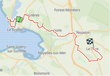
Trail Mountain bike of 32 km to be discovered at Hauts-de-France, Somme, Le Crotoy. This trail is proposed by marc6262.
Description
de la ballade le long des chemins PR du coin - jolies passages dans le marais.
Découvrez les usages du silex extrait dans les carrières !
Positioning
Country:
France
Region :
Hauts-de-France
Department/Province :
Somme
Municipality :
Le Crotoy
Location:
Unknown
Start:(Dec)
Start:(UTM)
401869 ; 5564127 (31U) N.
Comments
Trails nearby
![Trail Walking Saint-Valery-sur-Somme - Balade à Saint-Valéry-sur-Somme - Photo](https://media.geolcdn.com/t/375/260/ext.jpg?maxdim=2&url=https%3A%2F%2Fservices.sitytrail.com%2FGeolivesWS%2FDownloadMedia.ashx%3FTrailID%3D438142%26Media%3Dfed88654-3b60-4043-bb2e-e5c8c6773117.JPG)
![Walking Walking](https://static1.geolcdn.com/sitytour/trail-icons/101.png)
Balade à Saint-Valéry-sur-Somme
Walking
Easy
(4)
Saint-Valery-sur-Somme,
Hauts-de-France,
Somme,
France
![](/images/other/stat-length.png)
10.4 km | 12.2 km-effort
2h 41min
![](https://static1.geolcdn.com/siteimages/upload/files/16400158638029165_repeat_loop_refresh_sync_direction_icon.png)
Yes
![Trail Walking Le Crotoy - CDT80-3 - Photo](https://media.geolcdn.com/t/375/260/cef91e86-689f-4bd7-8591-33e387b29cb5.jpg&format=jpg&maxdim=2)
![Walking Walking](https://static1.geolcdn.com/sitytour/trail-icons/101.png)
CDT80-3
Walking
Medium
(2)
Le Crotoy,
Hauts-de-France,
Somme,
France
![](/images/other/stat-length.png)
6 km | 6.1 km-effort
1h 23min
![](https://static1.geolcdn.com/siteimages/upload/files/16400158638029165_repeat_loop_refresh_sync_direction_icon.png)
Yes
![Trail Walking Cayeux-sur-Mer - Le Hourdel V2 - Photo](https://media.geolcdn.com/t/375/260/ext.jpg?maxdim=2&url=https%3A%2F%2Fservices.sitytrail.com%2FGeolivesWS%2FDownloadMedia.ashx%3FTrailID%3D108609%26Media%3D1517_1.jpg)
![Walking Walking](https://static1.geolcdn.com/sitytour/trail-icons/101.png)
Le Hourdel V2
Walking
Difficult
(1)
Cayeux-sur-Mer,
Hauts-de-France,
Somme,
France
![](/images/other/stat-length.png)
8 km | 8.4 km-effort
2h 30min
![](https://static1.geolcdn.com/siteimages/upload/files/16400158638029165_repeat_loop_refresh_sync_direction_icon.png)
Yes
![Trail Walking Saint-Valery-sur-Somme - Balade à Saint-Valery sur Somme - Photo](https://media.geolcdn.com/t/375/260/ext.jpg?maxdim=2&url=https%3A%2F%2Fservices.sitytrail.com%2FGeolivesWS%2FDownloadMedia.ashx%3FTrailID%3D108607%26Media%3D1515_1.jpg)
![Walking Walking](https://static1.geolcdn.com/sitytour/trail-icons/101.png)
Balade à Saint-Valery sur Somme
Walking
Medium
(3)
Saint-Valery-sur-Somme,
Hauts-de-France,
Somme,
France
![](/images/other/stat-length.png)
7.1 km | 8.6 km-effort
2h 19min
![](https://static1.geolcdn.com/siteimages/upload/files/16400158638029165_repeat_loop_refresh_sync_direction_icon.png)
Yes
![Trail Walking Favières - Circuit de Morlay - Photo](https://media.geolcdn.com/t/375/260/ext.jpg?maxdim=2&url=https%3A%2F%2Fservices.sitytrail.com%2FGeolivesWS%2FDownloadMedia.ashx%3FTrailID%3D108602%26Media%3D1510_1.jpg)
![Walking Walking](https://static1.geolcdn.com/sitytour/trail-icons/101.png)
Circuit de Morlay
Walking
Difficult
(1)
Favières,
Hauts-de-France,
Somme,
France
![](/images/other/stat-length.png)
12.4 km | 12.8 km-effort
4h 0min
![](https://static1.geolcdn.com/siteimages/upload/files/16400158638029165_repeat_loop_refresh_sync_direction_icon.png)
Yes
![Trail Walking Saint-Valery-sur-Somme - Traversée Baie de Somme 11/08/2021 - Photo](https://media.geolcdn.com/t/375/260/486a482e-6345-45f3-b041-b66bc4ab348e.jpg&format=jpg&maxdim=2)
![Walking Walking](https://static1.geolcdn.com/sitytour/trail-icons/101.png)
Traversée Baie de Somme 11/08/2021
Walking
Medium
Saint-Valery-sur-Somme,
Hauts-de-France,
Somme,
France
![](/images/other/stat-length.png)
8.5 km | 8.8 km-effort
2h 0min
![](https://static1.geolcdn.com/siteimages/upload/files/16400158638029165_repeat_loop_refresh_sync_direction_icon.png)
No
![Trail Walking Saint-Valery-sur-Somme - w-frankrijk-over-dijken-en-kwelders - Photo](https://media.geolcdn.com/t/375/260/ext.jpg?maxdim=2&url=https%3A%2F%2Fstatic1.geolcdn.com%2Fsiteimages%2Fupload%2Ffiles%2F1553511878bg_sport_marche.png)
![Walking Walking](https://static1.geolcdn.com/sitytour/trail-icons/101.png)
w-frankrijk-over-dijken-en-kwelders
Walking
Very easy
(2)
Saint-Valery-sur-Somme,
Hauts-de-France,
Somme,
France
![](/images/other/stat-length.png)
13.8 km | 14.9 km-effort
Unknown
![](https://static1.geolcdn.com/siteimages/upload/files/16400158638029165_repeat_loop_refresh_sync_direction_icon.png)
Yes
![Trail Mountain bike Saint-Valery-sur-Somme - Gravelot Baie de sommes - Photo](https://media.geolcdn.com/t/375/260/ext.jpg?maxdim=2&url=https%3A%2F%2Fstatic1.geolcdn.com%2Fsiteimages%2Fupload%2Ffiles%2F1524743154velo.jpg)
![Mountain bike Mountain bike](https://static1.geolcdn.com/sitytour/trail-icons/202.png)
Gravelot Baie de sommes
Mountain bike
Easy
(1)
Saint-Valery-sur-Somme,
Hauts-de-France,
Somme,
France
![](/images/other/stat-length.png)
44 km | 47 km-effort
4h 56min
![](https://static1.geolcdn.com/siteimages/upload/files/16400158638029165_repeat_loop_refresh_sync_direction_icon.png)
Yes
![Trail Equestrian Le Crotoy - de la Maye vers marquenterre - Photo](https://media.geolcdn.com/t/375/260/ext.jpg?maxdim=2&url=https%3A%2F%2Fstatic1.geolcdn.com%2Fsiteimages%2Fupload%2Ffiles%2F1524743154cheval.jpg)
![Equestrian Equestrian](https://static1.geolcdn.com/sitytour/trail-icons/300.png)
de la Maye vers marquenterre
Equestrian
Very easy
(4)
Le Crotoy,
Hauts-de-France,
Somme,
France
![](/images/other/stat-length.png)
20 km | 21 km-effort
2h 43min
![](https://static1.geolcdn.com/siteimages/upload/files/16400158638029165_repeat_loop_refresh_sync_direction_icon.png)
No