Trail Mountain bike Théminettes - Critérium 2017 - Photo

Critérium 2017

 goutal
goutal

User

© OpenStreetMap contributors
Length
Length
17.8 km
Max alt
Max alt
364 m
Uphill gradient
Uphill gradient
233 m
Km-Effort
Km-Effort  
21 km
Min alt
Min alt
322 m
Downhill gradient
Downhill gradient
234 m
Boucle
Boucle
Yes
Creation date :
2017-03-19 00:00:00.0
Updated on :
2017-03-19 00:00:00.0

(0 Reviews)

Mountain bike
Mountain bike
1h22
Difficulty : Easy

Scan this QR Code to open this trail in the SityTrail application

FREE GPS app for hiking

Logo SityTrail SityTrail

IGN / Geographical institutes

Download SityTrail from the App Store Download SityTrail from Google Play

Logo SityTrail SityTrail World

The world is yours!

Download SityTrail from the App Store Download SityTrail from Google Play Download SityTrail on Huawei AppGallery

About

Trail Mountain bike of 17.8 km to be discovered at Occitania, Lot, Théminettes. This trail is proposed by goutal.

Description

Randoguide   cartographie à Théminettes

Elevation profile

Positioning

Country:
France
Region :
Occitania
Department/Province :
Lot
Municipality :
Théminettes
Location:
Unknown
Start:(UTM)
409227 ; 4951907 (31T) N.

Trails nearby

Trail Walking Sonac - Theminettes Les Causses - Photo
Walking
gannet1

Walking

Easy
(4)
Sonac, Occitania, Lot, France
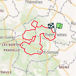
14.6 km | 17.3 km-effort
3h 46min
No
Trail Walking Théminettes - Theminette  - Photo
Walking
Gegetop

Walking

Easy
Théminettes, Occitania, Lot, France
10.7 km | 12.4 km-effort
2h 36min
Yes
Trail Walking Théminettes - Theminettes dolmen - Photo
Walking
gannet1

Walking

Very easy
Théminettes, Occitania, Lot, France
9.8 km | 11.4 km-effort
2h 29min
Yes
Trail Walking Thémines - Themines Rueyres 11km5-12030072 - Photo
Walking
houbart

Walking

Difficult
Thémines, Occitania, Lot, France
10.8 km | 14 km-effort
3h 10min
Yes
Trail Walking Thémines - themine - Photo
Walking
thomas.o.vert

Walking

Easy
Thémines, Occitania, Lot, France
10.6 km | 13.2 km-effort
2h 47min
Yes
Trail Walking Rudelle - rudelle - Photo
Walking
thomas.o.vert

Walking

Easy
Rudelle, Occitania, Lot, France
9.3 km | 11.6 km-effort
2h 17min
Yes
Trail Walking Théminettes - theminettes - Photo
Walking
thomas.o.vert

Walking

Easy
Théminettes, Occitania, Lot, France
11.9 km | 13.9 km-effort
2h 47min
Yes
Trail Walking Rueyres - rueyes  rudelle - Photo
Walking
gcournac

Walking

Difficult
Rueyres, Occitania, Lot, France
14.4 km | 18.1 km-effort
3h 32min
No
Trail Walking Assier - assier rs  - Photo
Walking
gcournac

Walking

Easy
Assier, Occitania, Lot, France
5 km | 5.8 km-effort
1h 30min
No


Close
My subscriptions