Trail Other activity Mauges-sur-Loire - moulin vigne sour - Photo
 louis49
louis49

User

© OpenStreetMap contributors
Length
Length
11.3 km
Max alt
Max alt
83 m
Uphill gradient
Uphill gradient
158 m
Km-Effort
Km-Effort  
13.4 km
Min alt
Min alt
23 m
Downhill gradient
Downhill gradient
162 m
Boucle
Boucle
Yes
Creation date :
2017-03-17 00:00:00.0
Updated on :
2017-03-17 00:00:00.0

(1 Reviews)

Other activity
Other activity
--
Difficulty : Unknown

Scan this QR Code to open this trail in the SityTrail application

FREE GPS app for hiking

Logo SityTrail SityTrail

IGN / Geographical institutes

Download SityTrail from the App Store Download SityTrail from Google Play

Logo SityTrail SityTrail World

The world is yours!

Download SityTrail from the App Store Download SityTrail from Google Play Download SityTrail on Huawei AppGallery

About

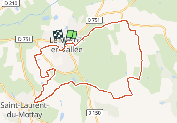
Trail Other activity of 11.3 km to be discovered at Pays de la Loire, Maine-et-Loire, Mauges-sur-Loire. This trail is proposed by louis49.

Elevation profile

Positioning

Country:
France
Region :
Pays de la Loire
Department/Province :
Maine-et-Loire
Municipality :
Mauges-sur-Loire
Location:
Unknown
Start:(UTM)
655859 ; 5247819 (30T) N.

Comments

Please log in to post a review or rate the element


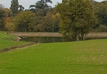
tres jolie randonnée autours des vignes et moulins à vent. Beau panorama sur la vallée de la Thau.


Trails nearby

Trail On foot Ingrandes-le-Fresne-sur-Loire - Vallée de la Loire Rive droite par Champtocé - Photo
On foot
GUIDE+

On foot

Easy
Ingrandes-le-Fresne-sur-Loire, Pays de la Loire, Maine-et-Loire, France
8 km | 8.7 km-effort
1h 58min
No
Trail On foot Loireauxence - Les Coteaux de Bray - Photo
On foot
GUIDE+

On foot

Easy
Loireauxence, Pays de la Loire, Loire-Atlantique, France
14.6 km | 16 km-effort
3h 38min
Yes
Trail On foot Montrelais - La Grande Verrière - Photo
On foot
GUIDE+

On foot

Easy
Montrelais, Pays de la Loire, Loire-Atlantique, France
8.8 km | 9.4 km-effort
2h 8min
No
Trail Walking Mauges-sur-Loire - Saint Laurent-du-Mottay - Photo
Walking
louis49

Walking

Medium
Mauges-sur-Loire, Pays de la Loire, Maine-et-Loire, France
10.1 km | 11.7 km-effort
2h 32min
Yes
Trail Other activity Mauges-sur-Loire - Ingrandes 17.7 km - Photo
Other activity
doclocjl

Other activity

Very easy
Mauges-sur-Loire, Pays de la Loire, Maine-et-Loire, France
17.7 km | 19.3 km-effort
5h 30min
Yes
Trail Walking Mauges-sur-Loire - le Mesnil en vallet - Photo
Walking
bellicaud

Walking

Medium
Mauges-sur-Loire, Pays de la Loire, Maine-et-Loire, France
11.6 km | 13.8 km-effort
3h 35min
Yes
Trail Mountain bike Ingrandes-le-Fresne-sur-Loire - Ingrandes 2023 - Photo
Mountain bike
pates_au_chaud

Mountain bike

Very difficult
Ingrandes-le-Fresne-sur-Loire, Pays de la Loire, Maine-et-Loire, France
42 km | 47 km-effort
3h 7min
Yes
Trail Other activity Mauges-sur-Loire - boucle au départ de l hôtel Poisson d argent - Photo
Other activity
doclocjl

Other activity

Very easy
Mauges-sur-Loire, Pays de la Loire, Maine-et-Loire, France
9.7 km | 10.5 km-effort
3h 19min
Yes
Trail Cycle Mauges-sur-Loire - 20070624Chateaubriant - Photo
Cycle
gpstracks

Cycle

Very easy
Mauges-sur-Loire, Pays de la Loire, Maine-et-Loire, France
76 km | 84 km-effort
Unknown
No


Close
My subscriptions