![](/images/other/stat-length.png)
![Trail Walking Avaux - Avaux-Asfeld AR - Photo](https://media.geolcdn.com/t/1900/400/ext.pjpeg?maxdim=2&url=https%3A%2F%2Fstatic1.geolcdn.com%2Fsiteimages%2Fupload%2Ffiles%2F1553511878bg_sport_marche.png)
Avaux-Asfeld AR
remi.servel
User
![Length](/images/other/stat-length.png)
Length
11 km
![Max alt](https://static1.geolcdn.com/siteimages/upload/files/1508320355ic_sort_altitude_max_24dp.png)
Max alt
80 m
![Uphill gradient](https://static1.geolcdn.com/siteimages/upload/files/1508320355ic_sort_den_pos_24dp.png)
Uphill gradient
72 m
![Km-Effort](/images/other/stat-length.png)
Km-Effort
12 km
![Min alt](https://static1.geolcdn.com/siteimages/upload/files/1508320355ic_sort_altitude_min_24dp.png)
Min alt
56 m
![Downhill gradient](https://static1.geolcdn.com/siteimages/upload/files/1508320355ic_sort_den_neg_24dp.png)
Downhill gradient
72 m
![Boucle](https://static1.geolcdn.com/siteimages/upload/files/16400158638029165_repeat_loop_refresh_sync_direction_icon.png)
Boucle
Yes
Creation date :
2015-09-30 00:00:00.0
Updated on :
2015-09-30 00:00:00.0
![Walking](https://static1.geolcdn.com/sitytour/trail-icons/101.png)
2h40
Difficulty : Very easy
![Scan this QR Code to open this trail in the SityTrail application](https://capi.geolives.com/qq0zvz2zws4bq2lad0pu/sitytour/trails/713000/qr.png?size=200)
FREE GPS app for hiking
About
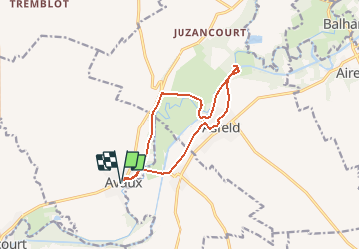
Trail Walking of 11 km to be discovered at Grand Est, Ardennes, Avaux. This trail is proposed by remi.servel.
Description
Rando le long du canal et de la rivière Aisne.
Depart Avaux
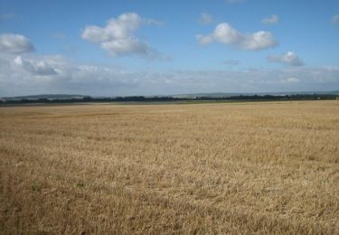
A voire: Arrivé a l'écluse traverser le pont à gauche, aller jusque au bord de la riviere (barrage)
Petite Chapelle a l'entrée d'Asfeld sur le chemin du retour.
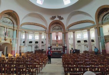
Ne pas rater Eglise St Didier construction de style unique au monde
Positioning
Country:
France
Region :
Grand Est
Department/Province :
Ardennes
Municipality :
Avaux
Location:
Unknown
Start:(Dec)
Start:(UTM)
578552 ; 5478710 (31U) N.
Comments
Trails nearby
![Trail Walking Vieux-lès-Asfeld - Chemin de Compostelle, Voie de Vézelay GR654® De Vieux lès Asfeld à Reims - Photo](https://media.geolcdn.com/t/375/260/ext.jpg?maxdim=2&url=https%3A%2F%2Fservices.sitytrail.com%2FGeolivesWS%2FDownloadMedia.ashx%3FTrailID%3D109400%26Media%3D3731_1.jpg)
![Walking Walking](https://static1.geolcdn.com/sitytour/trail-icons/101.png)
Chemin de Compostelle, Voie de Vézelay GR654® De Vieux lès Asfeld à Reims
Walking
Difficult
Vieux-lès-Asfeld,
Grand Est,
Ardennes,
France
![](/images/other/stat-length.png)
26 km | 28 km-effort
5h 15min
![](https://static1.geolcdn.com/siteimages/upload/files/16400158638029165_repeat_loop_refresh_sync_direction_icon.png)
No
![Trail Walking Vieux-lès-Asfeld - 23_08_2024_Vieux les Asfeld - Photo](https://media.geolcdn.com/t/375/260/e1b82c5b-e96f-4be0-bff2-db08cf3ee224.jpg&format=jpg&maxdim=2)
![Walking Walking](https://static1.geolcdn.com/sitytour/trail-icons/101.png)
23_08_2024_Vieux les Asfeld
Walking
Medium
Vieux-lès-Asfeld,
Grand Est,
Ardennes,
France
![](/images/other/stat-length.png)
8.6 km | 9.2 km-effort
2h 5min
![](https://static1.geolcdn.com/siteimages/upload/files/16400158638029165_repeat_loop_refresh_sync_direction_icon.png)
Yes
![Trail Walking Asfeld - Asfeld- Vieux les Asfeld A-R - Photo](https://media.geolcdn.com/t/375/260/ext.jpg?maxdim=2&url=https%3A%2F%2Fstatic1.geolcdn.com%2Fsiteimages%2Fupload%2Ffiles%2F1553511878bg_sport_marche.png)
![Walking Walking](https://static1.geolcdn.com/sitytour/trail-icons/101.png)
Asfeld- Vieux les Asfeld A-R
Walking
Very easy
(1)
Asfeld,
Grand Est,
Ardennes,
France
![](/images/other/stat-length.png)
7.2 km | 7.8 km-effort
1h 44min
![](https://static1.geolcdn.com/siteimages/upload/files/16400158638029165_repeat_loop_refresh_sync_direction_icon.png)
Yes
![Trail Walking Avaux - Avaux-Asfeld AR - Photo](https://media.geolcdn.com/t/375/260/ext.jpg?maxdim=2&url=https%3A%2F%2Fstatic1.geolcdn.com%2Fsiteimages%2Fupload%2Ffiles%2F1553511878bg_sport_marche.png)
![Walking Walking](https://static1.geolcdn.com/sitytour/trail-icons/101.png)
Avaux-Asfeld AR
Walking
Very easy
Avaux,
Grand Est,
Ardennes,
France
![](/images/other/stat-length.png)
11 km | 12 km-effort
2h 40min
![](https://static1.geolcdn.com/siteimages/upload/files/16400158638029165_repeat_loop_refresh_sync_direction_icon.png)
Yes