![](/images/other/stat-length.png)
![Trail Walking Romilly-sur-Andelle - Romilly-sur-Andelle 2017-03-09 - GD - 9km - Photo](https://media.geolcdn.com/t/1900/400/ext.pjpeg?maxdim=2&url=https%3A%2F%2Fstatic1.geolcdn.com%2Fsiteimages%2Fupload%2Ffiles%2F1553511878bg_sport_marche.png)
Romilly-sur-Andelle 2017-03-09 - GD - 9km
philippe76
User
![Length](/images/other/stat-length.png)
![Max alt](https://static1.geolcdn.com/siteimages/upload/files/1508320355ic_sort_altitude_max_24dp.png)
![Uphill gradient](https://static1.geolcdn.com/siteimages/upload/files/1508320355ic_sort_den_pos_24dp.png)
![Km-Effort](/images/other/stat-length.png)
![Min alt](https://static1.geolcdn.com/siteimages/upload/files/1508320355ic_sort_altitude_min_24dp.png)
![Downhill gradient](https://static1.geolcdn.com/siteimages/upload/files/1508320355ic_sort_den_neg_24dp.png)
![Boucle](https://static1.geolcdn.com/siteimages/upload/files/16400158638029165_repeat_loop_refresh_sync_direction_icon.png)
![Walking](https://static1.geolcdn.com/sitytour/trail-icons/101.png)
2h36
Difficulty : Medium
![Scan this QR Code to open this trail in the SityTrail application](https://capi.geolives.com/qq0zvz2zws4bq2lad0pu/sitytour/trails/709215/qr.png?size=200)
FREE GPS app for hiking
About
Trail Walking of 9.2 km to be discovered at Normandy, Eure, Romilly-sur-Andelle. This trail is proposed by philippe76.
Description
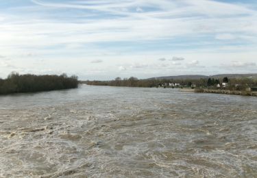
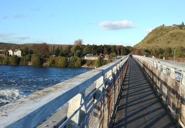
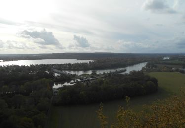
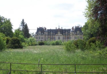
Départ parking du Collège rue de la Libération. Prendre le chemin aux bœufs. Après le cimetière Chemin AD, et TD jusqu'à l'Andelle, puis Avenue du Chateau. AG Grande Rue, AD rue des hautes rives, et AG traverser le chemin de fer.AD chemin montant, AG suivre le GRP "le royaume de Pïtres". Sur le plateau AD (avant rte du Plessis, AD et AG en traversant la rte des 2 amants. AD, AD et passer près de la mare Ruchon, AG rte des 2 amants et faire un crochet au Belvédère des 2 amants.
Prendre ensuite un chemin pour descendre vers la D19 (non représenté sur la carte). AG avenue de la Gare, TD et AD chemin du marche, puis AG Chemin Roussel, TD et AG sentier ds jardins du Levant. AD Arrivée rue le la libération.
Positioning
Comments
Trails nearby
![Trail Walking Amfreville-sous-les-Monts - Côte des Deux amants (107) - Photo](https://media.geolcdn.com/t/375/260/ext.jpg?maxdim=2&url=https%3A%2F%2Fstatic1.geolcdn.com%2Fsiteimages%2Fupload%2Ffiles%2F1553511878bg_sport_marche.png)
![Walking Walking](https://static1.geolcdn.com/sitytour/trail-icons/101.png)
Walking
![](/images/other/stat-length.png)
![](https://static1.geolcdn.com/siteimages/upload/files/16400158638029165_repeat_loop_refresh_sync_direction_icon.png)
![Trail Walking Pont-Saint-Pierre - 27-03-Flipou Pont Saint Pierre 14km-486-478- - Photo](https://media.geolcdn.com/t/375/260/5f192092-f3eb-4914-a0dc-a7ccf7ccb6ff.jpg&format=jpg&maxdim=2)
![Walking Walking](https://static1.geolcdn.com/sitytour/trail-icons/101.png)
Walking
![](/images/other/stat-length.png)
![](https://static1.geolcdn.com/siteimages/upload/files/16400158638029165_repeat_loop_refresh_sync_direction_icon.png)
![Trail Walking Pont-Saint-Pierre - 20240409-Flipou - Photo](https://media.geolcdn.com/t/375/260/88d68366-9846-42f8-8298-7e7b63133a02.jpg&format=jpg&maxdim=2)
![Walking Walking](https://static1.geolcdn.com/sitytour/trail-icons/101.png)
Walking
![](/images/other/stat-length.png)
![](https://static1.geolcdn.com/siteimages/upload/files/16400158638029165_repeat_loop_refresh_sync_direction_icon.png)
![Walking Walking](https://static1.geolcdn.com/sitytour/trail-icons/101.png)
Walking
![](/images/other/stat-length.png)
![](https://static1.geolcdn.com/siteimages/upload/files/16400158638029165_repeat_loop_refresh_sync_direction_icon.png)
![Walking Walking](https://static1.geolcdn.com/sitytour/trail-icons/101.png)
![Trail Walking Amfreville-sous-les-Monts - 2023-11-14_19h20m12_activity_ppses_2YB5CqjD45NlyPy1ooHxJn51nhV - Photo](https://media.geolcdn.com/t/375/260/b2f08aa4-2a1d-49db-9d1b-23ac53c5301f.jpg&format=jpg&maxdim=2)
![Walking Walking](https://static1.geolcdn.com/sitytour/trail-icons/101.png)
Walking
![](/images/other/stat-length.png)
![](https://static1.geolcdn.com/siteimages/upload/files/16400158638029165_repeat_loop_refresh_sync_direction_icon.png)
![Trail Walking Poses - Poses le Val Pitan - Photo](https://media.geolcdn.com/t/375/260/4c42f14a-6884-4e67-8d15-a7596b1ce635.jpg&format=jpg&maxdim=2)
![Walking Walking](https://static1.geolcdn.com/sitytour/trail-icons/101.png)
Walking
![](/images/other/stat-length.png)
![](https://static1.geolcdn.com/siteimages/upload/files/16400158638029165_repeat_loop_refresh_sync_direction_icon.png)
![Walking Walking](https://static1.geolcdn.com/sitytour/trail-icons/101.png)
Walking
![](/images/other/stat-length.png)
![](https://static1.geolcdn.com/siteimages/upload/files/16400158638029165_repeat_loop_refresh_sync_direction_icon.png)