![](/images/other/stat-length.png)
![Trail Walking Saint-Julien-en-Quint - Du Quint à Gagère par la porte d'urle - Photo](https://media.geolcdn.com/t/1900/400/ext.pjpeg?maxdim=2&url=https%3A%2F%2Fstatic1.geolcdn.com%2Fsiteimages%2Fupload%2Ffiles%2F1553511878bg_sport_marche.png)
Du Quint à Gagère par la porte d'urle
fabal
User
![Length](/images/other/stat-length.png)
Length
18.3 km
![Max alt](https://static1.geolcdn.com/siteimages/upload/files/1508320355ic_sort_altitude_max_24dp.png)
Max alt
1643 m
![Uphill gradient](https://static1.geolcdn.com/siteimages/upload/files/1508320355ic_sort_den_pos_24dp.png)
Uphill gradient
1202 m
![Km-Effort](/images/other/stat-length.png)
Km-Effort
34 km
![Min alt](https://static1.geolcdn.com/siteimages/upload/files/1508320355ic_sort_altitude_min_24dp.png)
Min alt
590 m
![Downhill gradient](https://static1.geolcdn.com/siteimages/upload/files/1508320355ic_sort_den_neg_24dp.png)
Downhill gradient
1205 m
![Boucle](https://static1.geolcdn.com/siteimages/upload/files/16400158638029165_repeat_loop_refresh_sync_direction_icon.png)
Boucle
Yes
Creation date :
2017-03-03 00:00:00.0
Updated on :
2017-03-03 00:00:00.0
![Walking](https://static1.geolcdn.com/sitytour/trail-icons/101.png)
7h14
Difficulty : Difficult
![Scan this QR Code to open this trail in the SityTrail application](https://capi.geolives.com/qq0zvz2zws4bq2lad0pu/sitytour/trails/708039/qr.png?size=200)
FREE GPS app for hiking
About
Trail Walking of 18.3 km to be discovered at Auvergne-Rhône-Alpes, Drôme, Saint-Julien-en-Quint. This trail is proposed by fabal.
Description
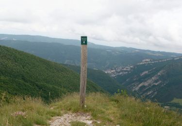
Départ des Faures en direction de la porte d'urle.
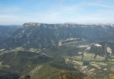
On suit la falaise jusqu'au Puy de la Gagère.
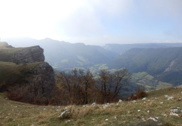
Descente jusqu'au col de Payanne puis vers le hameau des Bonnets
Positioning
Country:
France
Region :
Auvergne-Rhône-Alpes
Department/Province :
Drôme
Municipality :
Saint-Julien-en-Quint
Location:
Unknown
Start:(Dec)
Start:(UTM)
681802 ; 4969238 (31T) N.
Comments
Trails nearby
![Trail Walking Omblèze - 2021-07-26_17h20m33_1627312809705_Plateau d_Ambel 15km.gpx.xml - Photo](https://media.geolcdn.com/t/375/260/07e91571-7633-48aa-a91e-19fa46a2d0cc.jpg&format=jpg&maxdim=2)
![Walking Walking](https://static1.geolcdn.com/sitytour/trail-icons/101.png)
2021-07-26_17h20m33_1627312809705_Plateau d_Ambel 15km.gpx.xml
Walking
Very difficult
(1)
Omblèze,
Auvergne-Rhône-Alpes,
Drôme,
France
![](/images/other/stat-length.png)
14.9 km | 22 km-effort
4h 56min
![](https://static1.geolcdn.com/siteimages/upload/files/16400158638029165_repeat_loop_refresh_sync_direction_icon.png)
Yes
![Trail Walking Saint-Julien-en-Quint - Bec Pointu - Les Glovins - St-Julien-en-Quint - Photo](https://media.geolcdn.com/t/375/260/878efec7-ca71-44c9-bf9b-82849e6087b9.jpg&format=jpg&maxdim=2)
![Walking Walking](https://static1.geolcdn.com/sitytour/trail-icons/101.png)
Bec Pointu - Les Glovins - St-Julien-en-Quint
Walking
Difficult
Saint-Julien-en-Quint,
Auvergne-Rhône-Alpes,
Drôme,
France
![](/images/other/stat-length.png)
11.5 km | 22 km-effort
5h 40min
![](https://static1.geolcdn.com/siteimages/upload/files/16400158638029165_repeat_loop_refresh_sync_direction_icon.png)
Yes
![Trail Walking Saint-Julien-en-Quint - pas de bouillanain st julien en Quint - Photo](https://media.geolcdn.com/t/375/260/e24dab84-0d8d-4e1a-9d55-adf9e6345b23.jpg&format=jpg&maxdim=2)
![Walking Walking](https://static1.geolcdn.com/sitytour/trail-icons/101.png)
pas de bouillanain st julien en Quint
Walking
Difficult
Saint-Julien-en-Quint,
Auvergne-Rhône-Alpes,
Drôme,
France
![](/images/other/stat-length.png)
17 km | 29 km-effort
5h 6min
![](https://static1.geolcdn.com/siteimages/upload/files/16400158638029165_repeat_loop_refresh_sync_direction_icon.png)
Yes
![Trail Walking Vassieux-en-Vercors - But St Genis - Photo](https://media.geolcdn.com/t/375/260/7dc5994c-58ff-4977-a518-836cfc09796c.jpg&format=jpg&maxdim=2)
![Walking Walking](https://static1.geolcdn.com/sitytour/trail-icons/101.png)
But St Genis
Walking
Easy
Vassieux-en-Vercors,
Auvergne-Rhône-Alpes,
Drôme,
France
![](/images/other/stat-length.png)
12.8 km | 20 km-effort
3h 52min
![](https://static1.geolcdn.com/siteimages/upload/files/16400158638029165_repeat_loop_refresh_sync_direction_icon.png)
Yes
![Trail Walking Vassieux-en-Vercors - Forêt communale de Dié - Photo](https://media.geolcdn.com/t/375/260/81a065f0-a659-4198-8cfc-a4d3daa2067f.jpg&format=jpg&maxdim=2)
![Walking Walking](https://static1.geolcdn.com/sitytour/trail-icons/101.png)
Forêt communale de Dié
Walking
Difficult
Vassieux-en-Vercors,
Auvergne-Rhône-Alpes,
Drôme,
France
![](/images/other/stat-length.png)
10.7 km | 14.8 km-effort
3h 21min
![](https://static1.geolcdn.com/siteimages/upload/files/16400158638029165_repeat_loop_refresh_sync_direction_icon.png)
Yes
![Trail Walking Saint-Julien-en-Quint - Puy de la Gagere, Porte d’Urle - Photo](https://media.geolcdn.com/t/375/260/e2307571-55f1-4e4e-ad84-7190356d726e.jpg&format=jpg&maxdim=2)
![Walking Walking](https://static1.geolcdn.com/sitytour/trail-icons/101.png)
Puy de la Gagere, Porte d’Urle
Walking
Difficult
Saint-Julien-en-Quint,
Auvergne-Rhône-Alpes,
Drôme,
France
![](/images/other/stat-length.png)
19.3 km | 34 km-effort
6h 45min
![](https://static1.geolcdn.com/siteimages/upload/files/16400158638029165_repeat_loop_refresh_sync_direction_icon.png)
Yes
![Trail Walking Omblèze - Plateau d_Ambel 15km - Photo](https://media.geolcdn.com/t/375/260/0ff22542-c45b-4fc6-868c-010c97d00b52.jpg&format=jpg&maxdim=2)
![Walking Walking](https://static1.geolcdn.com/sitytour/trail-icons/101.png)
Plateau d_Ambel 15km
Walking
Medium
Omblèze,
Auvergne-Rhône-Alpes,
Drôme,
France
![](/images/other/stat-length.png)
14.8 km | 22 km-effort
4h 20min
![](https://static1.geolcdn.com/siteimages/upload/files/16400158638029165_repeat_loop_refresh_sync_direction_icon.png)
Yes
![Trail Walking Bouvante - Fond d'Urle Chaud Clapier - Photo](https://media.geolcdn.com/t/375/260/4a8e0c5c-95fa-438b-87df-304eace0b559.jpg&format=jpg&maxdim=2)
![Walking Walking](https://static1.geolcdn.com/sitytour/trail-icons/101.png)
Fond d'Urle Chaud Clapier
Walking
Medium
Bouvante,
Auvergne-Rhône-Alpes,
Drôme,
France
![](/images/other/stat-length.png)
12.7 km | 19.6 km-effort
4h 10min
![](https://static1.geolcdn.com/siteimages/upload/files/16400158638029165_repeat_loop_refresh_sync_direction_icon.png)
Yes
![Trail Walking Vassieux-en-Vercors - 26 but st génie raquettes - Photo](https://media.geolcdn.com/t/375/260/c60ab361-7569-4d55-9877-eaa92e5ab9b3.jpg&format=jpg&maxdim=2)
![Walking Walking](https://static1.geolcdn.com/sitytour/trail-icons/101.png)
26 but st génie raquettes
Walking
Medium
Vassieux-en-Vercors,
Auvergne-Rhône-Alpes,
Drôme,
France
![](/images/other/stat-length.png)
10.6 km | 16.8 km-effort
5h 26min
![](https://static1.geolcdn.com/siteimages/upload/files/16400158638029165_repeat_loop_refresh_sync_direction_icon.png)
No