Trail Cycle Baignes-Sainte-Radegonde - galope chopine 2 - Photo
 jylera
jylera

User

© OpenStreetMap contributors
Length
Length
14.8 km
Max alt
Max alt
117 m
Uphill gradient
Uphill gradient
138 m
Km-Effort
Km-Effort  
16.6 km
Min alt
Min alt
68 m
Downhill gradient
Downhill gradient
134 m
Boucle
Boucle
No
Creation date :
2017-03-02 00:00:00.0
Updated on :
2017-03-02 00:00:00.0

(1 Reviews)

Cycle
Cycle
1h13
Difficulty : Easy

Scan this QR Code to open this trail in the SityTrail application

FREE GPS app for hiking

Logo SityTrail SityTrail

IGN / Geographical institutes

Download SityTrail from the App Store Download SityTrail from Google Play

Logo SityTrail SityTrail World

The world is yours!

Download SityTrail from the App Store Download SityTrail from Google Play Download SityTrail on Huawei AppGallery

About

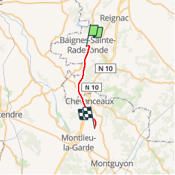
Trail Cycle of 14.8 km to be discovered at New Aquitaine, Charente, Baignes-Sainte-Radegonde. This trail is proposed by jylera.

Elevation profile

Positioning

Country:
France
Region :
New Aquitaine
Department/Province :
Charente
Municipality :
Baignes-Sainte-Radegonde
Location:
Unknown
Start:(UTM)
716189 ; 5029070 (30T) N.

Comments

Please log in to post a review or rate the element


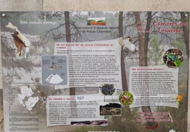
Attention si pluie ou humidité, zones glissantes ( surtout traversée D910 peinte en jaune) .


Trails nearby

Trail Walking Touvérac - Touverac 16. 15 mai 2018 - Photo
Walking
bert16

Walking

Very easy
Touvérac, New Aquitaine, Charente, France
3.9 km | 4.8 km-effort
1h 2min
Yes
Trail Mountain bike Baignes-Sainte-Radegonde - Les Cagouilles 50 km - Baignes Sainte Radegonde - Photo
Mountain bike
tracegps

Mountain bike

Medium
Baignes-Sainte-Radegonde, New Aquitaine, Charente, France
48 km | 55 km-effort
4h 0min
Yes
Trail Mountain bike Baignes-Sainte-Radegonde - Les Cagouilles - Baignes Sainte Radegonde - Photo
Mountain bike
tracegps

Mountain bike

Medium
Baignes-Sainte-Radegonde, New Aquitaine, Charente, France
35 km | 40 km-effort
3h 0min
Yes
Trail Walking Saint-Maigrin - Bois de Saint-Maigrin - Photo
Walking
neoroll44

Walking

Difficult
Saint-Maigrin, New Aquitaine, Charente-Maritime, France
10.4 km | 12.5 km-effort
2h 50min
Yes
Trail On foot Reignac - Reignac - Photo
On foot
dorcier

On foot

Very easy
Reignac, New Aquitaine, Charente, France
10.9 km | 12.8 km-effort
2h 30min
Yes
Trail Walking Bran - Bran 13 - Photo
Walking
JACQUOU

Walking

Medium
Bran, New Aquitaine, Charente-Maritime, France
12.3 km | 14.5 km-effort
2h 52min
Yes
Trail Walking Bran - Bran 15km - Photo
Walking
JACQUOU

Walking

Medium
Bran, New Aquitaine, Charente-Maritime, France
15.2 km | 17.6 km-effort
3h 20min
Yes
Trail Walking Baignes-Sainte-Radegonde - Baignes st Radegonde 13,8km - Photo
Walking
JACQUOU

Walking

Easy
Baignes-Sainte-Radegonde, New Aquitaine, Charente, France
13.8 km | 15.6 km-effort
2h 58min
Yes
Trail Walking Bran - Bran 11km - Photo
Walking
JACQUOU

Walking

Very easy
Bran, New Aquitaine, Charente-Maritime, France
10.8 km | 12.5 km-effort
2h 26min
Yes


Close
My subscriptions