![](/images/other/stat-length.png)
![Trail Snowshoes Saint-Christophe-sur-Guiers - la ruchere arpizon - Photo](https://media.geolcdn.com/t/1900/400/ext.pjpeg?maxdim=2&url=https%3A%2F%2Fstatic1.geolcdn.com%2Fsiteimages%2Fupload%2Ffiles%2F1524743153raquette.jpg)
la ruchere arpizon
floup6138
User
![Length](/images/other/stat-length.png)
Length
14.6 km
![Max alt](https://static1.geolcdn.com/siteimages/upload/files/1508320355ic_sort_altitude_max_24dp.png)
Max alt
1502 m
![Uphill gradient](https://static1.geolcdn.com/siteimages/upload/files/1508320355ic_sort_den_pos_24dp.png)
Uphill gradient
665 m
![Km-Effort](/images/other/stat-length.png)
Km-Effort
23 km
![Min alt](https://static1.geolcdn.com/siteimages/upload/files/1508320355ic_sort_altitude_min_24dp.png)
Min alt
1146 m
![Downhill gradient](https://static1.geolcdn.com/siteimages/upload/files/1508320355ic_sort_den_neg_24dp.png)
Downhill gradient
664 m
![Boucle](https://static1.geolcdn.com/siteimages/upload/files/16400158638029165_repeat_loop_refresh_sync_direction_icon.png)
Boucle
Yes
Creation date :
2017-02-27 00:00:00.0
Updated on :
2017-02-27 00:00:00.0
![Snowshoes](https://static1.geolcdn.com/sitytour/trail-icons/504.png)
5h26
Difficulty : Medium
![Scan this QR Code to open this trail in the SityTrail application](https://capi.geolives.com/qq0zvz2zws4bq2lad0pu/sitytour/trails/706068/qr.png?size=200)
FREE GPS app for hiking
About
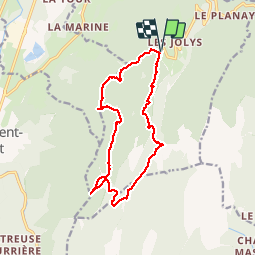
Trail Snowshoes of 14.6 km to be discovered at Auvergne-Rhône-Alpes, Isère, Saint-Christophe-sur-Guiers. This trail is proposed by floup6138.
Description
des beaux points de vue, des alternances de passages sans neige prévoir des cramponettes, une partie du circuit suit des pistes de fond. le passage qui suit le col de la ruchere est exposé au vent.
Positioning
Country:
France
Region :
Auvergne-Rhône-Alpes
Department/Province :
Isère
Municipality :
Saint-Christophe-sur-Guiers
Location:
Unknown
Start:(Dec)
Start:(UTM)
718871 ; 5032190 (31T) N.
Comments
Trails nearby
![Trail Snowshoes Saint-Christophe-sur-Guiers - Le Belvédère d'Arpison - Photo](https://media.geolcdn.com/t/375/260/ext.jpg?maxdim=2&url=https%3A%2F%2Fservices.sitytrail.com%2FGeolivesWS%2FDownloadMedia.ashx%3FTrailID%3D699429%26Media%3Dfix__20170216145739.jpg)
![Snowshoes Snowshoes](https://static1.geolcdn.com/sitytour/trail-icons/504.png)
Le Belvédère d'Arpison
Snowshoes
Medium
(1)
Saint-Christophe-sur-Guiers,
Auvergne-Rhône-Alpes,
Isère,
France
![](/images/other/stat-length.png)
11.1 km | 17.4 km-effort
4h 43min
![](https://static1.geolcdn.com/siteimages/upload/files/16400158638029165_repeat_loop_refresh_sync_direction_icon.png)
Yes
![Trail Walking Saint-Pierre-d'Entremont - Le Grand Som 2026m, depuis Saint-Philibert - Photo](https://media.geolcdn.com/t/375/260/ext.jpg?maxdim=2&url=https%3A%2F%2Fservices.sitytrail.com%2FGeolivesWS%2FDownloadMedia.ashx%3FTrailID%3D107472%26Media%3D12415_1.jpg)
![Walking Walking](https://static1.geolcdn.com/sitytour/trail-icons/101.png)
Le Grand Som 2026m, depuis Saint-Philibert
Walking
Difficult
(1)
Saint-Pierre-d'Entremont,
Auvergne-Rhône-Alpes,
Isère,
France
![](/images/other/stat-length.png)
11.2 km | 25 km-effort
7h 0min
![](https://static1.geolcdn.com/siteimages/upload/files/16400158638029165_repeat_loop_refresh_sync_direction_icon.png)
Yes
![Trail Walking Saint-Pierre-d'Entremont - Roche Veyrand par les Clapiers, 1429m - Photo](https://media.geolcdn.com/t/375/260/ext.jpg?maxdim=2&url=https%3A%2F%2Fservices.sitytrail.com%2FGeolivesWS%2FDownloadMedia.ashx%3FTrailID%3D101734%26Media%3D1981_1.jpg)
![Walking Walking](https://static1.geolcdn.com/sitytour/trail-icons/101.png)
Roche Veyrand par les Clapiers, 1429m
Walking
Difficult
(1)
Saint-Pierre-d'Entremont,
Auvergne-Rhône-Alpes,
Savoy,
France
![](/images/other/stat-length.png)
4.8 km | 14.3 km-effort
4h 10min
![](https://static1.geolcdn.com/siteimages/upload/files/16400158638029165_repeat_loop_refresh_sync_direction_icon.png)
Yes
![Trail Walking Saint-Christophe-sur-Guiers - Petit Som 1772m, depuis La Ruchère - Photo](https://media.geolcdn.com/t/375/260/ext.jpg?maxdim=2&url=https%3A%2F%2Fservices.sitytrail.com%2FGeolivesWS%2FDownloadMedia.ashx%3FTrailID%3D101428%26Media%3D1421_1.jpg)
![Walking Walking](https://static1.geolcdn.com/sitytour/trail-icons/101.png)
Petit Som 1772m, depuis La Ruchère
Walking
Medium
(2)
Saint-Christophe-sur-Guiers,
Auvergne-Rhône-Alpes,
Isère,
France
![](/images/other/stat-length.png)
6 km | 13.2 km-effort
3h 30min
![](https://static1.geolcdn.com/siteimages/upload/files/16400158638029165_repeat_loop_refresh_sync_direction_icon.png)
Yes
![Trail Road bike Corbel - Entreront - Photo](https://media.geolcdn.com/t/375/260/9b42e589-105e-4d70-99b0-df835d2b48ea.jpg&format=jpg&maxdim=2)
![Road bike Road bike](https://static1.geolcdn.com/sitytour/trail-icons/201.png)
Entreront
Road bike
Very difficult
(1)
Corbel,
Auvergne-Rhône-Alpes,
Savoy,
France
![](/images/other/stat-length.png)
34 km | 49 km-effort
2h 53min
![](https://static1.geolcdn.com/siteimages/upload/files/16400158638029165_repeat_loop_refresh_sync_direction_icon.png)
Yes
![Trail Walking Saint-Christophe-sur-Guiers - 38 grand som par sente intermediaire - Photo](https://media.geolcdn.com/t/375/260/d5932087-ede9-44fd-a20e-8bcb7625b7eb.jpg&format=jpg&maxdim=2)
![Walking Walking](https://static1.geolcdn.com/sitytour/trail-icons/101.png)
38 grand som par sente intermediaire
Walking
Medium
Saint-Christophe-sur-Guiers,
Auvergne-Rhône-Alpes,
Isère,
France
![](/images/other/stat-length.png)
14.5 km | 28 km-effort
7h 11min
![](https://static1.geolcdn.com/siteimages/upload/files/16400158638029165_repeat_loop_refresh_sync_direction_icon.png)
Yes
![Trail Walking Saint-Christophe - 38 st Christophe sur guiers grottes guiers vif - Photo](https://media.geolcdn.com/t/375/260/b80de980-1ba2-4651-878b-a9fe13ee8ba9.jpg&format=jpg&maxdim=2)
![Walking Walking](https://static1.geolcdn.com/sitytour/trail-icons/101.png)
38 st Christophe sur guiers grottes guiers vif
Walking
Medium
Saint-Christophe,
Auvergne-Rhône-Alpes,
Savoy,
France
![](/images/other/stat-length.png)
7.3 km | 12.7 km-effort
3h 24min
![](https://static1.geolcdn.com/siteimages/upload/files/16400158638029165_repeat_loop_refresh_sync_direction_icon.png)
Yes
![Trail Touring skiing Saint-Christophe-sur-Guiers - Col de mauvernay, de Bovinant, du Frêt et Petit Som - Photo](https://media.geolcdn.com/t/375/260/419264db-ef9b-4542-9a8f-6ba6585137b1.jpg&format=jpg&maxdim=2)
![Touring skiing Touring skiing](https://static1.geolcdn.com/sitytour/trail-icons/503.png)
Col de mauvernay, de Bovinant, du Frêt et Petit Som
Touring skiing
Medium
Saint-Christophe-sur-Guiers,
Auvergne-Rhône-Alpes,
Isère,
France
![](/images/other/stat-length.png)
12 km | 29 km-effort
6h 2min
![](https://static1.geolcdn.com/siteimages/upload/files/16400158638029165_repeat_loop_refresh_sync_direction_icon.png)
Yes
![Trail Walking Saint-Christophe-sur-Guiers - Petit Som par le Col de la Ruchère - Photo](https://media.geolcdn.com/t/375/260/ext.jpg?maxdim=2&url=https%3A%2F%2Fservices.sitytrail.com%2FGeolivesWS%2FDownloadMedia.ashx%3FTrailID%3D187990%26Media%3D84dca246-9935-47c1-bea7-9350caca3e85.JPG)
![Walking Walking](https://static1.geolcdn.com/sitytour/trail-icons/101.png)
Petit Som par le Col de la Ruchère
Walking
Medium
(2)
Saint-Christophe-sur-Guiers,
Auvergne-Rhône-Alpes,
Isère,
France
![](/images/other/stat-length.png)
7.1 km | 15.2 km-effort
3h 5min
![](https://static1.geolcdn.com/siteimages/upload/files/16400158638029165_repeat_loop_refresh_sync_direction_icon.png)
Yes