![](/images/other/stat-length.png)
![Trail Walking Fellering - les 2 Drumonts - Photo](https://media.geolcdn.com/t/1900/400/ext.pjpeg?maxdim=2&url=https%3A%2F%2Fstatic1.geolcdn.com%2Fsiteimages%2Fupload%2Ffiles%2F1553511878bg_sport_marche.png)
les 2 Drumonts
patrickbeyrath
User
![Length](/images/other/stat-length.png)
Length
13.9 km
![Max alt](https://static1.geolcdn.com/siteimages/upload/files/1508320355ic_sort_altitude_max_24dp.png)
Max alt
1221 m
![Uphill gradient](https://static1.geolcdn.com/siteimages/upload/files/1508320355ic_sort_den_pos_24dp.png)
Uphill gradient
677 m
![Km-Effort](/images/other/stat-length.png)
Km-Effort
23 km
![Min alt](https://static1.geolcdn.com/siteimages/upload/files/1508320355ic_sort_altitude_min_24dp.png)
Min alt
630 m
![Downhill gradient](https://static1.geolcdn.com/siteimages/upload/files/1508320355ic_sort_den_neg_24dp.png)
Downhill gradient
677 m
![Boucle](https://static1.geolcdn.com/siteimages/upload/files/16400158638029165_repeat_loop_refresh_sync_direction_icon.png)
Boucle
Yes
Creation date :
2018-10-13 05:54:06.427
Updated on :
2018-10-13 05:54:06.434
![Walking](https://static1.geolcdn.com/sitytour/trail-icons/101.png)
--
Difficulty : Difficult
![Scan this QR Code to open this trail in the SityTrail application](https://capi.geolives.com/qq0zvz2zws4bq2lad0pu/sitytour/trails/70293/qr.png?size=200)
FREE GPS app for hiking
About
Trail Walking of 13.9 km to be discovered at Grand Est, Haut-Rhin, Fellering. This trail is proposed by patrickbeyrath.
Description
Langmatt-Hasenkopf Rond Jaune et ensuite rond bleu jusqu'au Petit Drumont et puis rectangle Bleu vers le Drumont et après Faigne des Minons Triangle Jaune vers Langenbach et Arrivée à Langmatt
Positioning
Country:
France
Region :
Grand Est
Department/Province :
Haut-Rhin
Municipality :
Fellering
Location:
Unknown
Start:(Dec)
Start:(UTM)
347296 ; 5307057 (32T) N.
Comments
Trails nearby
![Trail Walking Bussang - Col de Bussang - Rouge Gazon - Séchenat - Photo](https://media.geolcdn.com/t/375/260/ext.jpg?maxdim=2&url=https%3A%2F%2Fservices.sitytrail.com%2FGeolivesWS%2FDownloadMedia.ashx%3FTrailID%3D450013%26Media%3Dfix__20150715145430.jpg)
![Walking Walking](https://static1.geolcdn.com/sitytour/trail-icons/101.png)
Col de Bussang - Rouge Gazon - Séchenat
Walking
Difficult
(1)
Bussang,
Grand Est,
Vosges,
France
![](/images/other/stat-length.png)
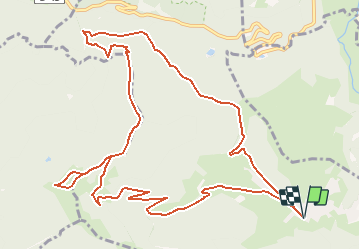
15 km | 24 km-effort
6h 0min
![](https://static1.geolcdn.com/siteimages/upload/files/16400158638029165_repeat_loop_refresh_sync_direction_icon.png)
No
![Trail Walking Storckensohn - lac des perches marchettes - Photo](https://media.geolcdn.com/t/375/260/ba8e93c4-c66a-48b1-88b8-cca79cc3effc.jpg&format=jpg&maxdim=2)
![Walking Walking](https://static1.geolcdn.com/sitytour/trail-icons/101.png)
lac des perches marchettes
Walking
Medium
(1)
Storckensohn,
Grand Est,
Haut-Rhin,
France
![](/images/other/stat-length.png)
11.9 km | 20 km-effort
4h 8min
![](https://static1.geolcdn.com/siteimages/upload/files/16400158638029165_repeat_loop_refresh_sync_direction_icon.png)
Yes
![Trail Walking Fellering - Felsach _chapelle ST Nicolas_frenz - Photo](https://media.geolcdn.com/t/375/260/ext.jpg?maxdim=2&url=https%3A%2F%2Fstatic1.geolcdn.com%2Fsiteimages%2Fupload%2Ffiles%2F1553511878bg_sport_marche.png)
![Walking Walking](https://static1.geolcdn.com/sitytour/trail-icons/101.png)
Felsach _chapelle ST Nicolas_frenz
Walking
Difficult
(3)
Fellering,
Grand Est,
Haut-Rhin,
France
![](/images/other/stat-length.png)
9.6 km | 16.5 km-effort
3h 45min
![](https://static1.geolcdn.com/siteimages/upload/files/16400158638029165_repeat_loop_refresh_sync_direction_icon.png)
Yes
![Trail Walking Oderen - 6146369-Chapelle St Nicolas 2 - Photo](https://media.geolcdn.com/t/375/260/ext.jpg?maxdim=2&url=https%3A%2F%2Fstatic1.geolcdn.com%2Fsiteimages%2Fupload%2Ffiles%2F1553511878bg_sport_marche.png)
![Walking Walking](https://static1.geolcdn.com/sitytour/trail-icons/101.png)
6146369-Chapelle St Nicolas 2
Walking
Medium
(1)
Oderen,
Grand Est,
Haut-Rhin,
France
![](/images/other/stat-length.png)
10.9 km | 17.9 km-effort
3h 41min
![](https://static1.geolcdn.com/siteimages/upload/files/16400158638029165_repeat_loop_refresh_sync_direction_icon.png)
Yes
![Trail Walking Kruth - le grand Ve tron - Photo](https://media.geolcdn.com/t/375/260/f2c4ef7b-d5ea-4350-b113-528ee63bd3d3.jpg&format=jpg&maxdim=2)
![Walking Walking](https://static1.geolcdn.com/sitytour/trail-icons/101.png)
le grand Ve tron
Walking
Medium
Kruth,
Grand Est,
Haut-Rhin,
France
![](/images/other/stat-length.png)
15.3 km | 25 km-effort
4h 0min
![](https://static1.geolcdn.com/siteimages/upload/files/16400158638029165_repeat_loop_refresh_sync_direction_icon.png)
No
![Trail Walking Oderen - TREK ALSACIEN (boucle, la meute) - Photo](https://media.geolcdn.com/t/375/260/bce13479-4ed1-47a7-a848-8fc9fefb1457.jpg&format=jpg&maxdim=2)
![Walking Walking](https://static1.geolcdn.com/sitytour/trail-icons/101.png)
TREK ALSACIEN (boucle, la meute)
Walking
Difficult
Oderen,
Grand Est,
Haut-Rhin,
France
![](/images/other/stat-length.png)
14.3 km | 23 km-effort
4h 30min
![](https://static1.geolcdn.com/siteimages/upload/files/16400158638029165_repeat_loop_refresh_sync_direction_icon.png)
Yes
![Trail Walking Oderen - Oderen Bergenbach Langenbach - Photo](https://media.geolcdn.com/t/375/260/05163254-f106-4300-b7bd-e85eb3e624ac.jpg&format=jpg&maxdim=2)
![Walking Walking](https://static1.geolcdn.com/sitytour/trail-icons/101.png)
Oderen Bergenbach Langenbach
Walking
Medium
Oderen,
Grand Est,
Haut-Rhin,
France
![](/images/other/stat-length.png)
7.1 km | 11.6 km-effort
3h 40min
![](https://static1.geolcdn.com/siteimages/upload/files/16400158638029165_repeat_loop_refresh_sync_direction_icon.png)
No
![Trail Walking Mollau - Le rossberg - Photo](https://media.geolcdn.com/t/375/260/e1c84c66-d799-45c0-a7df-12e4ffcf0bb2.jpg&format=jpg&maxdim=2)
![Walking Walking](https://static1.geolcdn.com/sitytour/trail-icons/101.png)
![Trail Walking Oderen - TREK ALSACIEN (1ère étape) - Photo](https://media.geolcdn.com/t/375/260/787fe892-71a8-4daf-8eb0-6ad69c3ebb22.jpg&format=jpg&maxdim=2)
![Walking Walking](https://static1.geolcdn.com/sitytour/trail-icons/101.png)
TREK ALSACIEN (1ère étape)
Walking
Medium
Oderen,
Grand Est,
Haut-Rhin,
France
![](/images/other/stat-length.png)
9.2 km | 18.1 km-effort
4h 0min
![](https://static1.geolcdn.com/siteimages/upload/files/16400158638029165_repeat_loop_refresh_sync_direction_icon.png)
No