Trail Snowshoes Bouvante - le puy de la  gageres - Photo
 guyzinz
guyzinz

User

© OpenStreetMap contributors
Length
Length
12.4 km
Max alt
Max alt
1643 m
Uphill gradient
Uphill gradient
549 m
Km-Effort
Km-Effort  
19.8 km
Min alt
Min alt
1336 m
Downhill gradient
Downhill gradient
558 m
Boucle
Boucle
Yes
Creation date :
2019-06-07 09:39:18.55
Updated on :
2019-06-07 09:39:18.676

(0 Reviews)

Snowshoes
Snowshoes
4h51
Difficulty : Easy

Scan this QR Code to open this trail in the SityTrail application

FREE GPS app for hiking

Logo SityTrail SityTrail

IGN / Geographical institutes

Download SityTrail from the App Store Download SityTrail from Google Play

Logo SityTrail SityTrail World

The world is yours!

Download SityTrail from the App Store Download SityTrail from Google Play Download SityTrail on Huawei AppGallery

About

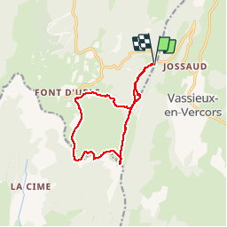
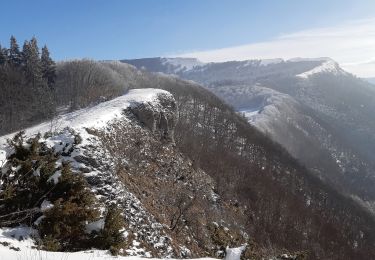
Trail Snowshoes of 12.4 km to be discovered at Auvergne-Rhône-Alpes, Drôme, Bouvante. This trail is proposed by guyzinz.

Description

Depart du col de la chau le puy de la gagere les crète de fond'urle paturage de fond'urle retour col de la chau  (5h-12,5km-695m)

Elevation profile

Positioning

Country:
France
Region :
Auvergne-Rhône-Alpes
Department/Province :
Drôme
Municipality :
Bouvante
Location:
Unknown
Start:(UTM)
685977 ; 4975258 (31T) N.

Trails nearby

Trail Snowshoes Bouvante - Les gagères en raquettes - Photo
Snowshoes
Simon Brabant

Snowshoes

Medium
(1)
Bouvante, Auvergne-Rhône-Alpes, Drôme, France
9.2 km | 14.2 km-effort
3h 40min
Yes
Trail Walking Bouvante - 01 - Photo
Walking
Noiraude

Walking

Medium
(1)
Bouvante, Auvergne-Rhône-Alpes, Drôme, France
12.5 km | 19.5 km-effort
5h 7min
Yes
Trail Snowshoes La Chapelle-en-Vercors - 26 raq claveyron - Photo
Snowshoes
GUIDE
randodyssée

Snowshoes

Medium
La Chapelle-en-Vercors, Auvergne-Rhône-Alpes, Drôme, France
15.2 km | 23 km-effort
7h 51min
Yes
Trail Walking La Chapelle-en-Vercors - serre plumé depuis carri par la bournette col de la baume grange de vauneyre col de la mure puis les cretes jusqu a pré bellet refuge de crobache lievre blanc scialet royer - Photo
Walking
bsateddy26

Walking

Very difficult
La Chapelle-en-Vercors, Auvergne-Rhône-Alpes, Drôme, France
15.5 km | 25 km-effort
5h 36min
Yes
Trail Walking Bouvante - Boucle du Plateau de Font d'Urle - Photo
Walking
GuyVachet

Walking

Difficult
Bouvante, Auvergne-Rhône-Alpes, Drôme, France
11.2 km | 16.8 km-effort
3h 49min
Yes
Trail Walking Vassieux-en-Vercors - Vassieux-en-Vercors - Le Puy de la Gagère - Photo
Walking
Philindy26

Walking

Easy
Vassieux-en-Vercors, Auvergne-Rhône-Alpes, Drôme, France
13.1 km | 21 km-effort
3h 45min
Yes
Trail Walking Bouvante - Font d’Urle les Trois cloches Glacières les Gagères  - Photo
Walking
alinetpierre

Walking

Difficult
Bouvante, Auvergne-Rhône-Alpes, Drôme, France
11.9 km | 17.9 km-effort
4h 4min
Yes
Trail Walking Vassieux-en-Vercors - Forêt communale de Dié - Photo
Walking
Greg813

Walking

Difficult
Vassieux-en-Vercors, Auvergne-Rhône-Alpes, Drôme, France
10.7 km | 14.8 km-effort
3h 21min
Yes
Trail Walking Bouvante - Crête des Gagères - Photo
Walking
Greg813

Walking

Medium
Bouvante, Auvergne-Rhône-Alpes, Drôme, France
8.3 km | 11.6 km-effort
2h 10min
Yes


Close
My subscriptions