![](/images/other/stat-length.png)
![Trail Walking Thoury-Férottes - 170215-RECO - BelleFontaine - Photo](https://media.geolcdn.com/t/1900/400/ext.pjpeg?maxdim=2&url=https%3A%2F%2Fservices.sitytrail.com%2FGeolivesWS%2FDownloadMedia.ashx%3FTrailID%3D699140%26Media%3Dfix__20170215105806.jpg)
170215-RECO - BelleFontaine
randodan
User
![Length](/images/other/stat-length.png)
Length
7.6 km
![Max alt](https://static1.geolcdn.com/siteimages/upload/files/1508320355ic_sort_altitude_max_24dp.png)
Max alt
157 m
![Uphill gradient](https://static1.geolcdn.com/siteimages/upload/files/1508320355ic_sort_den_pos_24dp.png)
Uphill gradient
132 m
![Km-Effort](/images/other/stat-length.png)
Km-Effort
9.3 km
![Min alt](https://static1.geolcdn.com/siteimages/upload/files/1508320355ic_sort_altitude_min_24dp.png)
Min alt
69 m
![Downhill gradient](https://static1.geolcdn.com/siteimages/upload/files/1508320355ic_sort_den_neg_24dp.png)
Downhill gradient
131 m
![Boucle](https://static1.geolcdn.com/siteimages/upload/files/16400158638029165_repeat_loop_refresh_sync_direction_icon.png)
Boucle
Yes
Creation date :
2017-02-17 00:00:00.0
Updated on :
2017-02-17 00:00:00.0
![Walking](https://static1.geolcdn.com/sitytour/trail-icons/101.png)
3h00
Difficulty : Easy
![Scan this QR Code to open this trail in the SityTrail application](https://capi.geolives.com/qq0zvz2zws4bq2lad0pu/sitytour/trails/699140/qr.png?size=200)
FREE GPS app for hiking
About
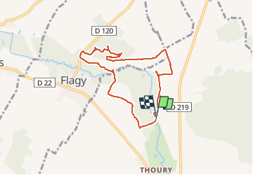
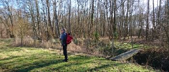
Trail Walking of 7.6 km to be discovered at Ile-de-France, Seine-et-Marne, Thoury-Férottes. This trail is proposed by randodan.
Description
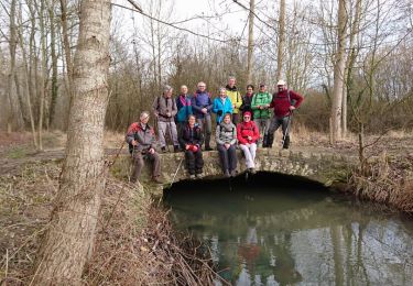
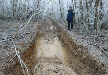
- Mercredi 15 février 2017 -<br>
RECO partielle avec JP 6005 (pour rando Pot-au-Feu Manureva 18-02-17)<br>
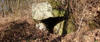
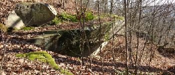
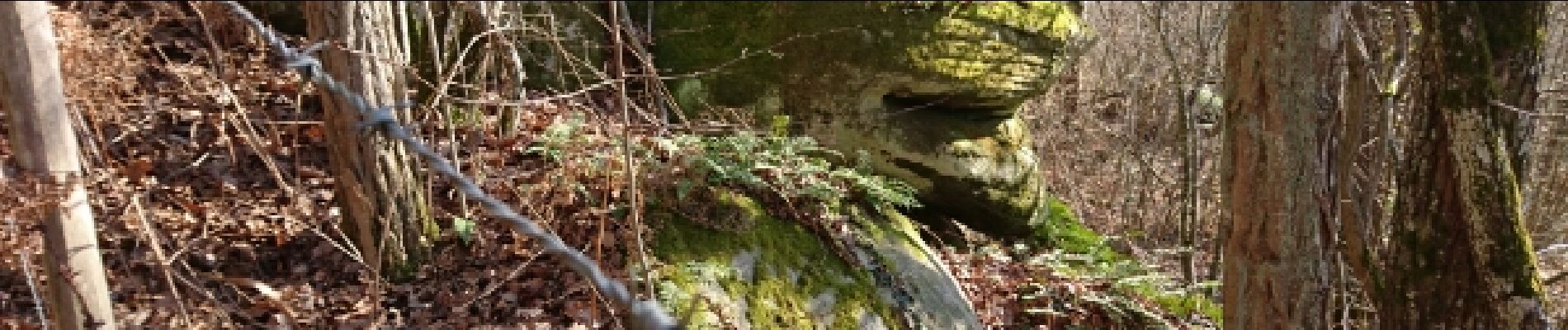
Recherche Rocher Sarrasins et vérif passage Orvanne Pré du Merle.<br>
Départ 10h, retour 13h.
Positioning
Country:
France
Region :
Ile-de-France
Department/Province :
Seine-et-Marne
Municipality :
Thoury-Férottes
Location:
Unknown
Start:(Dec)
Start:(UTM)
495686 ; 5350403 (31U) N.
Comments
Trails nearby
![Trail Walking Voulx - Entre Yonne et Orvalle - Photo](https://media.geolcdn.com/t/375/260/8fbb7b12-7e47-4de2-bcc1-b6997308259b.jpg&format=jpg&maxdim=2)
![Walking Walking](https://static1.geolcdn.com/sitytour/trail-icons/101.png)
Entre Yonne et Orvalle
Walking
Easy
Voulx,
Ile-de-France,
Seine-et-Marne,
France
![](/images/other/stat-length.png)
17.3 km | 21 km-effort
3h 34min
![](https://static1.geolcdn.com/siteimages/upload/files/16400158638029165_repeat_loop_refresh_sync_direction_icon.png)
Yes
![Trail On foot Ville-Saint-Jacques - Basse vallée de l'Orvanne - Photo](https://media.geolcdn.com/t/375/260/82137b8f-59f6-42a4-8e1b-17c82b952e9a.jpeg&format=jpg&maxdim=2)
![On foot On foot](https://static1.geolcdn.com/sitytour/trail-icons/100.png)
Basse vallée de l'Orvanne
On foot
Easy
Ville-Saint-Jacques,
Ile-de-France,
Seine-et-Marne,
France
![](/images/other/stat-length.png)
16 km | 19.1 km-effort
4h 20min
![](https://static1.geolcdn.com/siteimages/upload/files/16400158638029165_repeat_loop_refresh_sync_direction_icon.png)
Yes
![Trail On foot Montmachoux - Sentier des Croix - Photo](https://media.geolcdn.com/t/375/260/9c00f9f3-4ac0-46c5-bec8-6a060c59ec9b.jpeg&format=jpg&maxdim=2)
![On foot On foot](https://static1.geolcdn.com/sitytour/trail-icons/100.png)
Sentier des Croix
On foot
Easy
Montmachoux,
Ile-de-France,
Seine-et-Marne,
France
![](/images/other/stat-length.png)
5.5 km | 6.5 km-effort
1h 28min
![](https://static1.geolcdn.com/siteimages/upload/files/16400158638029165_repeat_loop_refresh_sync_direction_icon.png)
Yes
![Trail Walking Thoury-Férottes - 180111 EnCours - Photo](https://media.geolcdn.com/t/375/260/ext.jpg?maxdim=2&url=https%3A%2F%2Fservices.sitytrail.com%2FGeolivesWS%2FDownloadMedia.ashx%3FTrailID%3D886916%26Media%3Dfix__20180111125543.jpg)
![Walking Walking](https://static1.geolcdn.com/sitytour/trail-icons/101.png)
180111 EnCours
Walking
Very easy
Thoury-Férottes,
Ile-de-France,
Seine-et-Marne,
France
![](/images/other/stat-length.png)
16.7 km | 19.7 km-effort
5h 20min
![](https://static1.geolcdn.com/siteimages/upload/files/16400158638029165_repeat_loop_refresh_sync_direction_icon.png)
Yes
![Trail Walking Thoury-Férottes - Manu-170218 - Thoury-Dormelles - Photo](https://media.geolcdn.com/t/375/260/ext.jpg?maxdim=2&url=https%3A%2F%2Fservices.sitytrail.com%2FGeolivesWS%2FDownloadMedia.ashx%3FTrailID%3D700727%26Media%3D9d381017-48c9-49db-92ae-a1297989025d.jpg)
![Walking Walking](https://static1.geolcdn.com/sitytour/trail-icons/101.png)
Manu-170218 - Thoury-Dormelles
Walking
Easy
Thoury-Férottes,
Ile-de-France,
Seine-et-Marne,
France
![](/images/other/stat-length.png)
15.8 km | 18.8 km-effort
4h 45min
![](https://static1.geolcdn.com/siteimages/upload/files/16400158638029165_repeat_loop_refresh_sync_direction_icon.png)
Yes
![Trail Walking Dormelles - M&R-141219 - Dormelles - Photo](https://media.geolcdn.com/t/375/260/ext.jpg?maxdim=2&url=https%3A%2F%2Fservices.sitytrail.com%2FGeolivesWS%2FDownloadMedia.ashx%3FTrailID%3D371467%26Media%3D19e6ba95-3c6b-4ae7-8dc3-f0bbed2e93e0.jpg)
![Walking Walking](https://static1.geolcdn.com/sitytour/trail-icons/101.png)
M&R-141219 - Dormelles
Walking
Easy
Dormelles,
Ile-de-France,
Seine-et-Marne,
France
![](/images/other/stat-length.png)
10.9 km | 12.7 km-effort
3h 0min
![](https://static1.geolcdn.com/siteimages/upload/files/16400158638029165_repeat_loop_refresh_sync_direction_icon.png)
Yes
![Trail Walking Dormelles - M&R-131210 - Dormelles - Photo](https://media.geolcdn.com/t/375/260/ext.jpg?maxdim=2&url=https%3A%2F%2Fservices.sitytrail.com%2FGeolivesWS%2FDownloadMedia.ashx%3FTrailID%3D237422%26Media%3Dfix__20131210110652.jpg)
![Walking Walking](https://static1.geolcdn.com/sitytour/trail-icons/101.png)
M&R-131210 - Dormelles
Walking
Very easy
Dormelles,
Ile-de-France,
Seine-et-Marne,
France
![](/images/other/stat-length.png)
16.1 km | 19.3 km-effort
4h 9min
![](https://static1.geolcdn.com/siteimages/upload/files/16400158638029165_repeat_loop_refresh_sync_direction_icon.png)
Yes
![Trail Walking Thoury-Férottes - SVG 180111 - Photo](https://media.geolcdn.com/t/375/260/ext.jpg?maxdim=2&url=https%3A%2F%2Fservices.sitytrail.com%2FGeolivesWS%2FDownloadMedia.ashx%3FTrailID%3D886930%26Media%3Dfix__20180111125543.jpg)
![Walking Walking](https://static1.geolcdn.com/sitytour/trail-icons/101.png)
SVG 180111
Walking
Very easy
Thoury-Férottes,
Ile-de-France,
Seine-et-Marne,
France
![](/images/other/stat-length.png)
14.9 km | 17.8 km-effort
7h 20min
![](https://static1.geolcdn.com/siteimages/upload/files/16400158638029165_repeat_loop_refresh_sync_direction_icon.png)
No
![Trail Walking Thoury-Férottes - RECO Forteresse 161230 - Photo](https://media.geolcdn.com/t/375/260/ext.jpg?maxdim=2&url=https%3A%2F%2Fservices.sitytrail.com%2FGeolivesWS%2FDownloadMedia.ashx%3FTrailID%3D678529%26Media%3Dfix__20161230152354.jpg)
![Walking Walking](https://static1.geolcdn.com/sitytour/trail-icons/101.png)
RECO Forteresse 161230
Walking
Very easy
Thoury-Férottes,
Ile-de-France,
Seine-et-Marne,
France
![](/images/other/stat-length.png)
9.2 km | 11.3 km-effort
2h 28min
![](https://static1.geolcdn.com/siteimages/upload/files/16400158638029165_repeat_loop_refresh_sync_direction_icon.png)
Yes