![](/images/other/stat-length.png)
![Trail Walking Etxalar - ETXALAR - AIKOLEGI - AZKUA - ETXALAR - Photo](https://media.geolcdn.com/t/1900/400/ext.pjpeg?maxdim=2&url=https%3A%2F%2Fstatic1.geolcdn.com%2Fsiteimages%2Fupload%2Ffiles%2F1553511878bg_sport_marche.png)
ETXALAR - AIKOLEGI - AZKUA - ETXALAR
DECHAMPD
User
![Length](/images/other/stat-length.png)
![Max alt](https://static1.geolcdn.com/siteimages/upload/files/1508320355ic_sort_altitude_max_24dp.png)
![Uphill gradient](https://static1.geolcdn.com/siteimages/upload/files/1508320355ic_sort_den_pos_24dp.png)
![Km-Effort](/images/other/stat-length.png)
![Min alt](https://static1.geolcdn.com/siteimages/upload/files/1508320355ic_sort_altitude_min_24dp.png)
![Downhill gradient](https://static1.geolcdn.com/siteimages/upload/files/1508320355ic_sort_den_neg_24dp.png)
![Boucle](https://static1.geolcdn.com/siteimages/upload/files/16400158638029165_repeat_loop_refresh_sync_direction_icon.png)
![Walking](https://static1.geolcdn.com/sitytour/trail-icons/101.png)
6h36
Difficulty : Very difficult
![Scan this QR Code to open this trail in the SityTrail application](https://capi.geolives.com/qq0zvz2zws4bq2lad0pu/sitytour/trails/698537/qr.png?size=200)
FREE GPS app for hiking
About
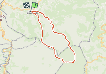
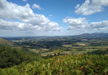
Trail Walking of 16.3 km to be discovered at Navarre, Unknown, Etxalar. This trail is proposed by DECHAMPD.
Description
Départ randonnée : village de Etxalar
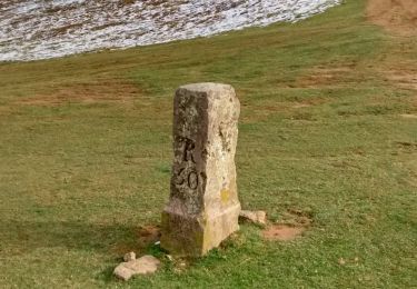
Très belle randonnée depuis le village de Etxalar, bien suivre la trace gps (éviter les 2 petites erreurs où j'ai dû faire 1/2 tour aux points gps 612218-4786950 et 612433-4786648) car aucune indication jusqu'aux crête où l'on rattrape le GR.
Depuis Aizkolegi suivre toute la crête sur chemin assez bien tracé jusqu'à l'Azkua puis rejoindre Etxalar par le GR.
La première moitié jusqu'à l'Aikolegi et longue et laborieuse car tout est en sous-bois.
aucune difficulté sur ce parcours.
Positioning
Comments
Trails nearby
![Trail On foot Etxalar - SL-NA 5 Argarata - Santa Krutz - Photo](https://media.geolcdn.com/t/375/260/94bbb8c0-a5b3-4c45-bc43-34bd6d9df6cd.jpeg&format=jpg&maxdim=2)
![On foot On foot](https://static1.geolcdn.com/sitytour/trail-icons/100.png)
On foot
![](/images/other/stat-length.png)
![](https://static1.geolcdn.com/siteimages/upload/files/16400158638029165_repeat_loop_refresh_sync_direction_icon.png)
![Trail Walking Sare - Lizarieta descente par palombieres - Photo](https://media.geolcdn.com/t/375/260/9d6ad3d3-a9ac-4160-b5e2-482251e1a583.jpg&format=jpg&maxdim=2)
![Walking Walking](https://static1.geolcdn.com/sitytour/trail-icons/101.png)
Walking
![](/images/other/stat-length.png)
![](https://static1.geolcdn.com/siteimages/upload/files/16400158638029165_repeat_loop_refresh_sync_direction_icon.png)
![Trail Walking Sare - col de lizarrieta et col des 3 bornes - Photo](https://media.geolcdn.com/t/375/260/4a8eca64-9908-469c-ac1f-6551c3878583.jpg&format=jpg&maxdim=2)
![Walking Walking](https://static1.geolcdn.com/sitytour/trail-icons/101.png)
Walking
![](/images/other/stat-length.png)
![](https://static1.geolcdn.com/siteimages/upload/files/16400158638029165_repeat_loop_refresh_sync_direction_icon.png)
![Trail Walking Sare - Lizarrieta, Zentinel, col des 3 bornes, 2024 03 04. - Photo](https://media.geolcdn.com/t/375/260/8ac35c6d-8e84-4286-9748-27c916c27140.jpg&format=jpg&maxdim=2)
![Walking Walking](https://static1.geolcdn.com/sitytour/trail-icons/101.png)
Walking
![](/images/other/stat-length.png)
![](https://static1.geolcdn.com/siteimages/upload/files/16400158638029165_repeat_loop_refresh_sync_direction_icon.png)
![Trail On foot Sare - Chemin des Palombières - Photo](https://media.geolcdn.com/t/375/260/13b91c3b-250a-4dae-aac3-8efba66e3a34.jpeg&format=jpg&maxdim=2)
![On foot On foot](https://static1.geolcdn.com/sitytour/trail-icons/100.png)
On foot
![](/images/other/stat-length.png)
![](https://static1.geolcdn.com/siteimages/upload/files/16400158638029165_repeat_loop_refresh_sync_direction_icon.png)
![Trail Walking Sare - Sare Les Plombières - Photo](https://media.geolcdn.com/t/375/260/407c166e-c326-48da-855d-67e057f1c1cf.jpg&format=jpg&maxdim=2)
![Walking Walking](https://static1.geolcdn.com/sitytour/trail-icons/101.png)
Walking
![](/images/other/stat-length.png)
![](https://static1.geolcdn.com/siteimages/upload/files/16400158638029165_repeat_loop_refresh_sync_direction_icon.png)
![Trail Walking Sare - le tour des plombières by phiphidechagny - Photo](https://media.geolcdn.com/t/375/260/ext.jpg?maxdim=2&url=https%3A%2F%2Fservices.sitytrail.com%2FGeolivesWS%2FDownloadMedia.ashx%3FTrailID%3D1131867%26Media%3Dfix__20190407134407.jpg)
![Walking Walking](https://static1.geolcdn.com/sitytour/trail-icons/101.png)
Walking
![](/images/other/stat-length.png)
![](https://static1.geolcdn.com/siteimages/upload/files/16400158638029165_repeat_loop_refresh_sync_direction_icon.png)
![Trail Walking Lesaka - BERA-MÉGALITHES DE AMARGUNKO - Photo](https://media.geolcdn.com/t/375/260/ext.jpg?maxdim=2&url=https%3A%2F%2Fservices.sitytrail.com%2FGeolivesWS%2FDownloadMedia.ashx%3FTrailID%3D669194%26Media%3Dfix__20161021132733.jpg)
![Walking Walking](https://static1.geolcdn.com/sitytour/trail-icons/101.png)
Walking
![](/images/other/stat-length.png)
![](https://static1.geolcdn.com/siteimages/upload/files/16400158638029165_repeat_loop_refresh_sync_direction_icon.png)
![Trail Walking Lesaka - ilasmendi depuis Bera - Photo](https://media.geolcdn.com/t/375/260/a417be49-fb64-41f6-81b7-12cc8075cd44.jpg&format=jpg&maxdim=2)
![Walking Walking](https://static1.geolcdn.com/sitytour/trail-icons/101.png)
Walking
![](/images/other/stat-length.png)
![](https://static1.geolcdn.com/siteimages/upload/files/16400158638029165_repeat_loop_refresh_sync_direction_icon.png)