Trail Walking Moulidars - Moulidars - Photo
 dorcier
dorcier

User

© OpenStreetMap contributors
Length
Length
11.3 km
Max alt
Max alt
104 m
Uphill gradient
Uphill gradient
145 m
Km-Effort
Km-Effort  
13.3 km
Min alt
Min alt
40 m
Downhill gradient
Downhill gradient
146 m
Boucle
Boucle
Yes
Creation date :
2017-02-12 00:00:00.0
Updated on :
2017-02-12 00:00:00.0

(0 Reviews)

Walking
Walking
2h54
Difficulty : Easy

Scan this QR Code to open this trail in the SityTrail application

FREE GPS app for hiking

Logo SityTrail SityTrail

IGN / Geographical institutes

Download SityTrail from the App Store Download SityTrail from Google Play

Logo SityTrail SityTrail World

The world is yours!

Download SityTrail from the App Store Download SityTrail from Google Play Download SityTrail on Huawei AppGallery

About

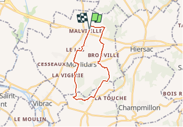
Trail Walking of 11.3 km to be discovered at New Aquitaine, Charente, Moulidars. This trail is proposed by dorcier.

Description

Départ et arrivée du lieu-dit Le Cluzeau à Malvieille : Cognac Rémy COUILLEBAUD" en bordure de la RN 141.

Elevation profile

Positioning

Country:
France
Region :
New Aquitaine
Department/Province :
Charente
Municipality :
Moulidars
Location:
Unknown
Start:(UTM)
731245 ; 5062551 (30T) N.

Trails nearby

Trail Walking  - chamillon21036 - Photo
Walking
dededavid

Walking

Medium
, , ,
5 km | 6.3 km-effort
1h 53min
Yes
Trail Walking Douzat - voir verte de Douzat - Photo
Walking
Jean-claude Dissard

Walking

Medium
Douzat, New Aquitaine, Charente, France
6.6 km | 7.7 km-effort
1h 59min
Yes
Trail Mountain bike Hiersac - rando hiersac - Photo
Mountain bike
Ludovic1976

Mountain bike

Medium
Hiersac, New Aquitaine, Charente, France
25 km | 30 km-effort
55h 31min
Yes
Trail Walking Hiersac - hiersac - Photo
Walking
sy!

Walking

Very easy
Hiersac, New Aquitaine, Charente, France
11.2 km | 13 km-effort
2h 28min
Yes
Trail Walking Graves-Saint-Amant - Graves St Amand 14-07-2016 - Photo
Walking
jmrobin

Walking

Easy
Graves-Saint-Amant, New Aquitaine, Charente, France
14.6 km | 16.6 km-effort
3h 17min
Yes
Trail Walking  - Champmillon - Photo
Walking
bmaron

Walking

Medium
, , ,
9.4 km | 11.2 km-effort
2h 40min
Yes
Trail Walking Vibrac - vibrac  - Photo
Walking
sy!

Walking

Medium
Vibrac, New Aquitaine, Charente, France
8.1 km | 8.6 km-effort
1h 40min
Yes
Trail Walking  - champmillon - Photo
Walking
bmaron

Walking

Medium
, , ,
9 km | 10.4 km-effort
2h 35min
Yes
Trail Walking  - champmillon - Photo
Walking
sy!

Walking

Medium
, , ,
8.7 km | 10 km-effort
1h 55min
Yes


Close
My subscriptions